Teresina
| Teresina |
| — Municipality — |
| The Municipality of Teresina |
|
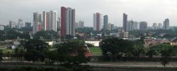
Downtown view. |
Flag |
Seal |
|
| Nickname(s): Capital do Sol e da Luz (Capital of Sun and Light),Cidade Verde (Green City) and THE. |
| Motto: Omnia in Charitate |
|
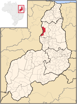
Location of Teresina in the State of Piauí |
|
|
| Country |
 Brazil Brazil |
| Region |
Northeast |
| State |
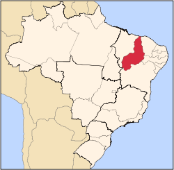
 Piauí Piauí |
| Founded |
1852 |
| Government |
| - Mayor |
Silvio Mendes (PSDB) |
| Area |
| - Municipality |
1,680 km2 (648.7 sq mi) |
| - Urban |
1,755 km2 (677 sq mi) |
| Population (2007) |
| - Municipality |
893,246 |
| - Density |
456.8/km2 (1,183.1/sq mi) |
| |
(est) |
| Time zone |
-3 |
| Postal Code |
64000-000 |
| Area code(s) |
+55 86 |
| HDI (2000) |
0.766 – medium |
| Website |
Teresina, Piauí |
Teresina is the capital and largest city of the Brazilian state of Piauí and the only inland capital in the northeastern region of the country. The central part of the city is situated between the Parnaíba and Poti rivers, as a result, the city is sometimes referred to as the "Mesopotamia of the Northeast." In the northern section of the city, the two rivers flow together and continue on toward the Atlantic. There is an environmental park at the confluence, with a viewing platform, which allows viewing from close range. Across the Parnaíba River from the capital lies the smaller city of Timon, which is part of the state of Maranhão. The city of Teresina is home to over 752,000 inhabitants, distributed over an area of 1,680 km2 (650 mi2). Its metropolitan area has about 996,000 inhabitants. The surrounding region is referred to as the Chapada do Corisco. The city was originally named Vila Nova do Poti, after the Poti River, and was later renamed Teresina in honor of the Empress Theresa Cristina, the wife of Dom Pedro II. The city has been the capital of the state since 1852, when it was founded by the governor of the province, José Saraiva, transferring the administrative headquarters of the province of Piauí from the city of Oeiras. Teresina was the first planned city in Brazil (earlier than the well-known planned capital city of Brasília, founded in 1960, and Belo Horizonte, capital of the state of Minas Gerais, founded in 1897); its design is said to be reminiscent of a chessboard. It is divided into quarters, with Dirceu Arcoverde being the most populous quarter. It is known as the "Green City" because of the countless mango trees that line its streets. Local crafts include ceramics. A monument depicts the legendary Cabeça de Cuia, a personality from local folklore. As it is located near the Equator, high temperatures in Teresina vary between 26 and 40 degrees Celsius (79 to 104 degrees Fahrenheit) throughout the year, with the lowest temperatures occurring in the first 5 months of the year. The hottest time of the year is October through December. Humidity is high year-round, with a low of approximately 40% and a high of about 90%, but is highest (80%-90%) from March to June. It is part of a highly urbanized complex known as Região Integrada de Desenvolvimento da Grande Teresina (Integrated Region of Development - Greater Teresina Area).
Geography
| Teresina |
| Climate chart () |
| J |
F |
M |
A |
M |
J |
J |
A |
S |
O |
N |
D |
|
|
|
|
|
|
|
|
|
|
|
|
|
| average max. and min. temperatures in °C |
| precipitation totals in mm |
| source: MSN Weather |
|
| Imperial conversion |
| J |
F |
M |
A |
M |
J |
J |
A |
S |
O |
N |
D |
|
|
|
|
|
|
|
|
|
|
|
|
|
| average max. and min. temperatures in °F |
| precipitation totals in inches |
|
Climate
Teresina has a tropical climate, specifically a tropical wet and dry climate. There are two seasons: the rainy one, from middle December to May, with heavy rainfalls, and the dry one, with scarce rain during the rest of the year. Temperatures remain relatively constant throughout the course of the year.
Vegetation
The typical flora of Teresina is the so-called "Mata de Cocais" (Palm Trees Forest), composed of palm trees like carnaúba, babaçu, buriti and tucum. It is a transition vegetation between the semi-arid xeric shrubland of Caatinga and the Amazon Rain Forest itself.
Economy
The GDP for the city was R$ 5,245,724,000 (2005).[1]
The per capita income for the city was R$ 6,650 (2005).[2]
Education
Portuguese is the official national language, and thus the primary language taught in schools. But English and Spanish are part of the official high school curriculum.
Universities at Teresina
- Universidade Federal do Piauí (UFPI);
- Universidade Estadual do Piauí (Uespi);
- Centro Federal de Educação Tecnológica do Piauí (CEFET-PI).
- Faculdade de Saúde, Ciências Humanas e Tecnológicas do Piauí (Faculdade Novafapi)
- Faculdade Integral Diferencial(Facid)
- Instituto Camilo Filho(ICF)
- Centro de Ensino Unificado de Teresina(CEUT)
- Faculdade das Atividades Empresariais de Teresina FAETE
Infrastructure
National Airport
Teresina/Senador Petrônio Portella Airport. Opened on September 30, 1967, Teresina Airport has been administered by Infraero since February 3, 1975. Teresina Airport is located four kilometers from downtown, roughly a ten-minute trip by car. It is 67 meters above sea level and the local temperature averages 30.9°C (87.62°F).
Metro
Teresina Metro is the metro system in Teresina. It is operated by CMTP (Companhia Metropolitana de Transportes Públicos). and was opened in 1990.
Sports
There are four football clubs in the city, River Atlético Clube, Esporte Clube Flamengo, Sociedade Esportiva Tiradentes and Auto Esporte Clube. There are two stadiums, named Estádio Governador Alberto Tavares Silva and Estádio Lindolfo Monteiro.
The sprinter Cláudio Roberto Souza was born in Teresina in 1973.
References
External links
|
Brazil topics |
|
| History |
|
|
| Politics |
|
|
| Law |
Law enforcement · Supreme Federal Tribunal · Human rights (LGBT rights) · Anti-discrimination laws · Order of Attorneys
|
|
| Economy |
Real · Central Bank · List of companies · Agriculture · Industry · Economic history · Telecommunications · Tourism
|
|
| Geography |
|
|
| Demographics |
People · Languages · Religion · Immigration · Education · Health · Crime · Social issues · Largest cities · Apartheid
|
|
| Culture |
|
|
| Transport |
High-speed rail · Highway · Railways · Airports · Bus Rapid Transit
|
|
| Energy |
|
|
| Sports |
|
|
| Other topics |
Military · International rankings · Science and technology · Mercosul · Potential superpowers
|
|
 Category · Category ·  Portal · Portal ·  WikiProject WikiProject |
|
|
Demographics of Brazil |
|
| Economic and social |
|
|
| European immigration |
Armenian · Austrian · Belgian · Bulgarian · Croatian · Czech · Dutch · English · Finnish · French · German · Greek · Hungarian · Irish · Italian · Jewish · Latvian · Lithuanian · Luxembourger · Macedonian · Maltese · Polish · Portuguese · Russian · Scandinavian · Scottish · Spanish · Swiss · Ukrainian
|
|
| Arab Brazilians |
Lebanese · Palestinian · Syrian
|
|
| South American Brazilians |
Argentine · Bolivian · Chilean · Paraguayan · Peruvian · Uruguayan
|
|
| American Brazilians |
American (Confederados)
|
|
| Mixed-race Brazilians |
Pardo (Caboclo · Cafuzo · Mulatto)
|
|
| African Brazilians |
|
|
| Asian Brazilians |
|
|
| Native Brazilians |
|
|
| Caribbean Brazilians |
Caribbean
|
|
|
50 largest cities of Brazil by population |
|
| |
|
|
|
- Sorocaba
- Ribeirão Preto
- Cuiabá
- Feira de Santana
- Juiz de Fora
- Aracaju
- Londrina
- Ananindeua
- Joinville
- Belford Roxo
|
- Niterói
- São João de Meriti
- Aparecida de Goiânia
- Campos dos Goytacazes
- Santos
- São José do Rio Preto
- Mauá
- Caxias do Sul
- Betim
- Vila Velha
|
|
|