Makati
| City of Makati Lungsod ng Makati |
|||
|---|---|---|---|
| — City — | |||
 |
|||
|
|||
| Nickname(s): The Financial Capital of the Philippines,the Wall Street of the Phils. | |||
| Motto: Makati, Mahalin Natin, Atin Ito | |||
 |
|||
 City of Makati
|
|||
| Coordinates: | |||
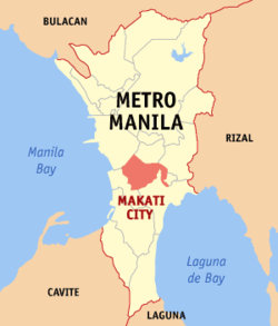
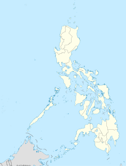
| Country | Philippines | ||
| Region | National Capital Region | ||
| Districts | 1st and 2nd districts of Makati City | ||
| Barangays | 33 | ||
| Settled | 1670 | ||
| Cityhood | January 2, 1995 | ||
| Government | |||
| - Type | Mayor–council government | ||
| - Mayor | Jejomar Erwin S. Binay, Jr. (PDP-Laban) | ||
| - Vice Mayor | Romulo V. Peña, Jr. (Independent) | ||
| - Makati City Council |
Councilors
|
||
| Area | |||
| - Total | 27.36 km2 (10.6 sq mi) | ||
| Elevation | 15.4 m (51 ft) | ||
| Population (2007) | |||
| - Total | 510,383 | ||
| - Density | 18,654/km2 (48,313.6/sq mi) | ||
| Time zone | PST (UTC+8) | ||
| ZIP code | 1200 to 1299 | ||
| Area code(s) | 2 | ||
| Twin Cities | |||
| - Cluj-Napoca | Romania | ||
| - Los Angeles | United States | ||
| - Ramapo | United States | ||
| - Vladivostok | Russia | ||
| - Dumaguete | Philippines | ||
| - Iligan | Philippines | ||
| - Santa Rosa | Philippines | ||
| - Cabanatuan | Philippines | ||
| - San Antonio | Philippines | ||
| Website | makati.gov.ph | ||
The City of Makati (pronounced /məˈkɑːtɪ/ mə-KAH-tee; Filipino: Makati) is one of the 16 cities that make up Metro Manila, one of the most populous metropolitan areas in the world. Makati is the financial center of the Philippines and one of the major financial, commercial and economic hubs in Asia. As the host of various embassies, it is also an important center for international affairs.
With a population of 510,383, Makati is the 16th largest city in the country and ranked as the 40th most densely populated city in the world with 18,654 inhabitants per km2.
Makati was founded by Spaniard Miguel López de Legazpi, who dismissed Makati as a worthless swamp. According to folklore, Legazpi asked for the name of the place but, because of the language barrier, was misinterpreted by the natives. Pointing to the receding tide of Pasig River, the natives answered, “Makati, kumakati na,” literally meaning ebbing tide.
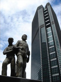
Makati became the financial center of the Philippines during the 1950s. Many districts and landmarks in the city have become well known to outsiders. Makati has been iconified as the "Financial Capital of the Philippines". Anchored by Ayala Avenue, Makati is the financial capital of the Philippines and is the home of the Philippine Stock Exchange and the Makati Business Club, one of the most important economic hubs in the Philippines. World-class research universities are located in the city.
Contents |
The city
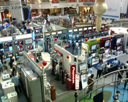
Makati is noted for its highly cosmopolitan culture, also being a major cultural and entertainment hub in Metro Manila. Many expatriates live and work in the city. Makati is also home to many first-class shopping malls, which are located at Ayala Center and Rockwell Center. Makati also has the tallest buildings in the Philippines like PBCom Tower, G.T. International Tower.
The city also has many of the country's five-star hotels like The Peninsula Manila, the Shangri-La Hotel Makati and the Intercontinental Hotel Manila. Independent business travelers also benefit from budget hotels like the Saint Illian's Inn, El Cielito Inn, The Copa Businessman's Hotel, and The City Garden Suites, while serviced apartments like The Salcedo Suites, Fraser Place Manila, Jupiter Suites (Jupiter Arms Hotel) and The Oxford Suites are gaining in popularity among business-minded travelers as well.
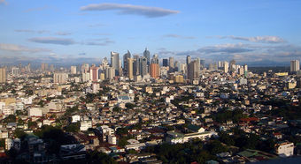
Today the city is one of the most modern cities in the country and the Philippines' major global economic competitor in Asia. However, it faces challenges due to the disparate gap between the new city in the west, which contains the Central Business District, and the old city in the east, which is largely poor and where most of the city's slums are located. Despite this, Makati City is said to be the most outstanding and richest city in the Philippines.
History
| Date | Milestone |
|---|---|
| 1578 | It was Miguel López de Legazpi, the founder of Manila and first Governor-General of the Philippines, who first spotted the area, which he dismissed then as a worthless swamp. Legazpi asked the name of the place but, because of the language barrier, was misinterpreted by the natives. Pointing to the receding tide of Pasig River, the natives answered, “Makati, kumakati na” meaning “ebbing tide.” |
| 1578 to 1670 | Makati was a “visita” or district of Santa Ana de Sapa under the jurisdiction of a Franciscan priest named Pedro de Alfaro. Makati was then known as San Pedro de Makati in honor of its patron saint. In this community, the friars established two of the earliest churches in the Philippines — the Nuestra Señora de Gracia in Guadalupe and the Church of Sts. Peter and Paul — in Makati, which attracted the faithful from all over the country. |
| 1900 | At the turn of the century, the Americans established Fort McKinley in Makati. |
| 1901 | San Pedro de Macati, with a population of 25,000, was incorporated into the province of Rizal. |
| February 28, 1914 | The Philippine Legislature passed Act 2390, shortening the name San Pedro de Macati to Makati in the 1930s, the first airport of Luzon, Nielson Field, opened in what is now the Ayala Triangle. |
| 1950s to 1970s | The first centrally planned community was established in the 1950s, and since the 1970s, Makati has been the undisputed financial and commercial capital, the once worthless swampland becoming prime real property. |
| 1975 | Makati was separated from Rizal province along with Caloocan, Malabon, Navotas, Quezon City, Marikina, San Juan, Pasig, Mandaluyong, Pateros, Taguig, Pasay City, Parañaque, Las Pinas, and Muntinlupa. |
| 1980s | Makati has also figured prominently in the political history of the Filipino. The community was one of the cradles of the revolt against Spanish colonial rule, and following the assassination of Ninoy Aquino in 1983, the epicenter of the protest movement against the dictatorship of President Ferdinand E. Marcos. |
| 1986 | Jejomar C. Binay was inaugurated as an acting mayor by Corazon C. Aquino after the People Power in EDSA and he was elected as mayor in 1987. |
| January 2, 1995 | Makati became an independent city by virtue of Republic Act 7854. |
| June 30, 1998 | The Lone District of Makati City was separated and divided into 2 districts. Lone District Representative Joker Arroyo became the representative of the first district, while Senator Agapito Aquino was elected representative of second district. Elenita Binay became the first female city mayor. |
| July 27, 2003 | The so-called Oakwood Mutiny was staged at the Oakwood Hotel by the Magdalo soldiers, in protest against President Gloria Macapagal-Arroyo. |
| October 19, 2007 | An accidental methane gas explosion ripped apart a section of the Glorietta Mall at 1:30 PM, killing 11 persons. |
| November 29, 2007 | In a continuation of events stemming from the Oakwood Mutiny, 25 Magdalo Officers led by Senator Antonio Trillanes IV and Brigadier General Danilo Lim overtook the Manila Peninsula Hotel in what has been referred to as the Manila Pen Siege. |
Geography and Landmarks

Makati City is located within the circle of 14′40″ °north and 121′3″ °E right at the center of Metro Manila. The city is bounded on the north by the Pasig River, facing Mandaluyong City, on the northeast by Pasig City, on the southeast by the municipality of Pateros and Taguig City, on the northwest by the City of Manila, and on the southwest by Pasay City. Makati has a total land area of 27.36 square kilometers; it constitutes 4.3% of Metro Manila's total land area.
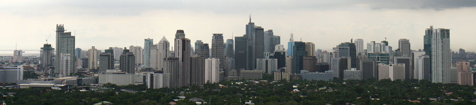
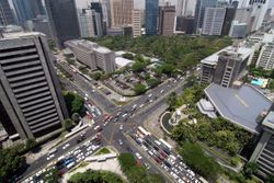
At the center of the city is the Central Business District (CBD) where many companies in the Philippines have their offices or headquarters. This is where many of the country's tallest skyscrapers are located. The Makati skyline is one of the most impressive sights in Metro Manila.
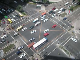
Two of Metro Manila's main arteries pass through Makati. The Epifanio De los Santos Avenue (EDSA) pass along the southeast part of Makati and connects the city with Mandaluyong City and Pasay City. The South Luzon Expressway (SLEX) runs through the western part of Makati and connects the city with Manila to the north and with southern Metro Manila. The Skyway, an elevated highway built on top of SLEX, provides residents coming from southern Metro Manila a fast way to reach Makati. SLEX and EDSA intersect at the Magallanes Interchange, which is the most complex system of elevated roadways in Metro Manila.
Other major roads in Makati include Gil Puyat Avenue, also called by its former name Buendia Avenue, which connects EDSA and SLEX in the north; Ayala Avenue, an important street that runs through the Central Business District; and Makati Avenue, which connects Ayala Avenue with Buendia Avenue, also extending north to cross the Pasig River to Mandaluyong City. At the center of Makati is the Ayala Triangle, a park built on the former Nielsen Air Base. The orientation of the main roads in the center of Makati, clearly not forming a standard grid as in many new cities, makes perfect sense as soon as you understand that Paseo de Roxas was Nielsen Field runway 07/25 and Ayala Avenue was runway 12/30, pretty much the same orientations as the present-day airport's runways, 06/24 and 13/31.
Makati's sister city is Los Angeles, California. Makati is also twinned with Ramapo, New York and Vladivostok, Russia.
Population
Makati City has a population of 567,349, according to the 2007 Census (includes disputed barangays). This figure represents an increase of 95,970 over the 2000 Census figure. Among the cities and municipalities in Metro Manila, Makati ranks fifth in population, with a 5% share. The 1903 Census placed the population at 2,700.
Although its population is slightly more than half a million, the daytime population of Makati City is estimated to be a million during a typical working weekday because of the large number of people who go to the city to work, shop, and do business, especially in the Central Business District.
Economy
The Central Business District (CBD) is where most of Makati's financial resources are concentrated. This is an informal district bounded by EDSA, Gil Puyat Ave., Antonio Arnaiz Avenue/Pasay Road, and Chino Roces Avenue. It mainly encompasses Legazpi Village, Salcedo Village, Ayala Center, and parts of Bel-Air. Much of the area is owned by Ayala Land, Inc and administered through Makati Commercial Estates Authority (MACEA), its subsidiary.
Many tall skyscrapers rise and are underconstruction in this area. PBCom Tower along Ayala Avenue is the country's tallest building and reaches up 259 meters.[1][2] It is the headquarters of the Philippine Bank of Communications, or PBCom. The Makati CBD is considered to be one of the most vibrant commercial districts in Southeast Asia.
One of the trading floors of the Philippine Stock Exchange is housed in Ayala Tower One and at the old Makati Stock Exchange Building, both also along Ayala Avenue. The Bank of the Philippine Islands (BPI), the country's oldest bank, has its headquarters at the corner of Ayala Avenue and Paseo de Roxas.
Other companies that have their offices and country/regional headquarters within Makati City, most within the CBD, include Thomson Reuters, Philippine Savings Bank (PSBank), IBM, Procter & Gamble, Citibank, Ayala Corporation, Development Bank of the Philippines (DBP), Metrobank, Intel Philippines, Microsoft Philippines, Nestlé, Syngenta, Shell,Startek International Ltd. Convergys Corporation, Commonwealth Insurance Company (CIC), Aegis PeopleSupport, Inc. (APS), Pan Pacific Computer Center, Inc. (PPCC), Colgate-Palmolive Philippines, Inc., Holcim Philippines,CEMEX PHILIPPINES and JG Summit, Accenture. Hewlett Packard's main Philippines office and an HP service center are in Makati City.[3] Asiana Airlines operates a sales office on the sixth floor of the Salcedo Tower in Makati City.[4]
In 1975 Philippine Airlines was headquartered in the PAL Building in Makati City.[5]
Diplomatic missions
Countries that have set-up permanent missions or offices in the city include:
Shopping centers
Ayala Center, along EDSA and Ayala Avenue is the most known commercial center in the city. Developed by the Ayala Corporation, it contains two shopping malls, Glorietta and Greenbelt, five star hotels, and an office building. The larger of the two shopping malls is Glorietta, which itself is a cluster of malls. Rising from Glorietta 4 is the Ascott Tower(formerly Oakwood Premier), a luxurious hotel-apartment residence at the heart of the center. Along the periphery of Glorietta are three department stores: SM Department Store Makati, Rustan's, and the Landmark. Across Makati Avenue from Glorietta is Greenbelt. This is one of the most sophisticated, modern, and expensive malls in the country. Greenbelt features dozens of coffee stores and restaurants, all overlooking a well-landscaped green park at the center where a domed Catholic chapel dominates the skyline. Other hotels in the vicinity of Ayala Center are the Makati Shangri-la Hotel, the Manila Peninsula, the Dusit Thani Group, the Hotel Intercontinental Manila, and Renaissance Makati City Hotel. Soon to rise is the Raffles Residences Manila, now under construction at the corner of Makati Avenue and Arnaiz Avenue.
Rockwell Center is the other first-class shopping center in Makati. Rockwell features the large Power Plant Mall popular with expatriates. At the periphery of the center are many high-class residential condominium towers, the Asian Eye Institute, and the Ateneo de Manila Professional Schools main campus, which houses the Ateneo Law School, the Ateneo Graduate School of Business, and the Ateneo School of Government.
Housing and residences
Many of the country's wealthiest families live in North and South Forbes Park, originally developed in 1948, and Dasmariñas Village, first developed in the 1960s, on the other side of EDSA from the Central Business District. Other well-to-do people live in San Lorenzo Village, Urdaneta Village, San Antonio Village, Bel-Air Village, and Magallanes Village. These "villages" are not rural settlements, but gated communities. Many wealthy and middle-class Makati residents live in high-rise condominiums in Salcedo Village and Legazpi Village, two mixed-use zones located in the heart of the CBD. Most of the average residents of the city live in the city's periphery, especially in the eastern portions of Cembo, Rizal, East and West Rembo, Pembo, Comembo, South Cembo, and Pitogo.
Education, culture, and sports
Educational Institutions in Makati City
- ABE International Business College
- AMA Computer College
- Asia Pacific College
- Asian Institute of Management (AIM)
- Asian Seminary of Christian Ministries (ASCM)
- Assumption College
- Ateneo Professional Schools
- Bangkal High School
- Benigno S. "Ninoy" Aquino Jr. Science High School[6]
- Bethany Baptist Academy Makati
- Centro Escolar University Makati
- Colegio San Agustin
- Colegio de Sta. Rosa[7]
- De La Salle-Professional Schools, Inc.
- Don Bosco Technical Institute, Makati Don Bosco Technical Institute, Makati
- First Academy of Computer Arts
- Far Eastern University - Makati Business School
- Fort Bonifacio High School[8]
- Gen. Pio Del Pilar National Science High School
- International Academy of Management and Economics (I.AME)
- Information and Communications Technology Academy
- Lyceum of the Philippines College of Law
- Rolf Jost Information Technologie Institute
- Makati High School
- Makati Hope Christian School[9]
- Makati Science High School
- Mapúa Institute of Technology
- Maranatha Christian Academy of Makati
- Our Lady of Guadalupe Minor Seminary
- Philippine School of Interior Design
- Pitogo High School
- RTRMS-Makati Medical Center
- St. Augustine School of Nursing
- San Carlos Seminary
- Saint Paul College of Makati[10]
- Saint Mary of the Woods School
- San Antonio National High School
- San Isidro National High School
- STI Makati
- Think & Try Learning Center
- University of Makati[11]
- Informatics Computer Institute of Makati
Makati City is home to the Asian Institute of Management (AIM). AIM, located along Paseo de Roxas across Greenbelt began as a collaborative project of the Ateneo de Manila University and De La Salle University. The Ateneo Professional Schools, a unit of the Ateneo de Manila University has facilities in Rockwell Center and Salcedo Village. The Rockwell campus houses the Ateneo Law School, the Ateneo Graduate School of Business, and the Ateneo School of Government. The Salcedo campus houses the Ateneo Information Technology Institute. De La Salle University's Professional Schools operates in RCBC Tower along Ayala Avenue. The Mapua Institute of Technology on Gil Puyat Avenue is an extension of Mapua in Intramuros, Manila.
Other notable colleges and Universities in Makati are the Asian Seminary of Christian Ministries (ASCM),[12] Don Bosco Technical Institute, Makati, Assumption College, Colegio San Agustin, Makati Hope Christian School, Our Lady of Guadalupe Minor Seminary, Asia Pacific College,International Academy of Management and Economics (I.AME)and the University of Makati. Assumption College, in San Lorenzo Village, is an all-female college. The University of Makati (officially, Pamantasan ng Makati) is a university run by the city government. Also in the city are the Makati Science High School and Benigno "Ninoy" Aquino High School, both city-run high schools. Remedios Trinidad Romualdez Memorial Schools, named after Doña Remedios Romualdez, the mother of the former first-lady Imelda Romualdez-Marcos a private nursing school owned by of one of Makati's renowned hospitals, Makati Medical Center.
The Sta. Ana Racetrack, which is actually already a part of the City of Manila, beside Pasig River in the northern part of the city, is one of the two centers of horseracing in the country—the other being the San Lazaro Leisure Park in Carmona, Cavite. Along the south-eastern border of Makati beyond Forbes Park are the Manila Golf Club and the Manila Polo Club.[13] The Manila Golf Club features an 18-hole golf course amidst the lush greenery of the city. The Manila Polo Club counts among its polo enthusiasts some of the country's wealthiest people. The Makati Sports Club in Salcedo Village is another popular place for sports people. The Makati Coliseum is another famous sports landmark in the city, where some of the biggest sports gatherings are held.
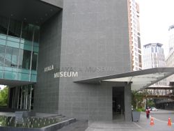
The Ayala Center also features, aside from its shopping malls, the Ayala Museum. This museum is most noted for its series of dioramas depicting major events in Philippine history, from the Battle of Mactan to the People Power Revolution.
Makati has many Spanish-era churches, such as the Our Lady of Guadalupe and the Nuestra Señora de Gracia (Our Lady of Grace) in the old town. At the Greenbelt Park stands the modern domed chapel of the Sto. Niño de la Paz. Between Forbes Park and Dasmariñas Village is the Santuario de San Antonio, a popular church for weddings in the Makati area. The National Shrine of the Sacred Heart is located in San Antonio Village.Makati also houses the country's only Jewish synagogue,Beth Yaacov.
At the northern part of the city is the 25-hectare Manila South Cemetery. Every All Saints Day, thousands of people flock to the cemetery to pay their respects to their deceased loved ones.
Transportation
Land
Buses plying the Epifanio de los Santos Avenue (EDSA/C-4) route from Baclaran in Parañaque to Quezon City and Caloocan City pass through the Central Business District daily. Jeepneys ply Makati's inner roads and connect the city to its surrounding towns and cities. The Metro Rail Transit (MRT-3) on EDSA has four stations located in Makati: Guadalupe, Buendia, Ayala and Magallanes. The Philippine National Railways meanwhile has three stations: Buendia, Pasay Road and EDSA. It is also accessed by 2 expressways, the following are Metro Manila Skyway and South Luzon Expressway.
Water
The Pasig River is located on the North of this city. The Pasig River Ferry Service has 2 stations. The following stations are Guadalupe and Valenzuela.
Government
Like other cities in the Philippines, Makati City is governed by a Mayor and Vice Mayor who are elected to three-year terms. The Mayor is the executive head and leads the city's departments in executing the city ordinances and improving public services. The Vice Mayor heads a legislative council consisting of 18 members: 8 Councilors from the First District, 8 Councilors from the Second District, the President of the Sangguniang Kabataan (Youth Council) Federation, representing the youth sector, and the President of the Association of Barangay Chairmen (ABC) as barangay sectoral representative. The council is in charge of creating the city's policies in the form of Ordinances and Resolutions.
Seal of Makati City
The official seal of Makati City depicts a silhouette of the territory of Makati. At the bottom is the Pasig River, located on the northern border of the city. The Guadalupe Church stands on the river and is the oldest church in Makati; a reference to Spanish influence. Behind the church rises the skyscrapers for which Makati City is well-known. Behind the skyscrapers are 33 rays representing the barangays of Makati. These barangays are grouped into two congressional districts, with each district represented by a congressman in the House of Representatives. Congressional District I occupies the western and modern half of the city, while District II covers the poorer half.
City council (2010-2013)
| Position | Name |
|---|---|
| Mayor | Jejomar Erwin S. Binay, Jr. |
| Vice Mayor | Romulo "Kid" Pena, Jr. |
| 1st District | |
| Congressman | Monique Q. Lagdameo |
| Councilors | Virgilio V. Hilario, Sr. |
| Maria Concepcion Yabut | |
| Arnold C. Magpantay | |
| Manuel Monsour Del Rosario III | |
| Tosca Puno-Ramos | |
| Romeo Medina. | |
| Marie Alethea Casal-Uy | |
| Ferdinand Eusebio. | |
| 2nd District | |
| Congresswoman | Atty. Mar-len Abigail S. Binay |
| Councilors | Nemesio Yabut, Jr. |
| Mary Ruth Tolentino | |
| Ma. Theresa Nilo de Lara | |
| Henry Jacome | |
| Leonardo Magpantay | |
| Salvador Pangilinan | |
| Nelson Pasia | |
| Vincent Sese | |
Barangays
| Barangay | Population (year 2004) |
Area (km2) |
District |
|---|---|---|---|
| Bangkal | 22,433 | 0.74 | (1st) |
| Bel-Air | 9,330 | 1.71 | (1st) |
| Carmona | 3,699 | 0.34 | (1st) |
| Cembo | 25,815 | 0.22 | (2nd) |
| Comembo | 14,174 | 0.27 | (2nd) |
| Dasmariñas | 5,757 | 1.90 | (1st) |
| East Rembo | 23,902 | 0.44 | (2nd) |
| Forbes Park | 3,420 | 2.53 | (1st) |
| Guadalupe Nuevo | 22,493 | 0.57 | (2nd) |
| Guadalupe Viejo | 13,632 | 0.62 | (2nd) |
| Kasilawan | 6,224 | 0.09 | (1st) |
| La Paz | 8,843 | 0.32 | (1st) |
| Magallanes | 7,509 | 1.20 | (1st) |
| Olympia | 20,172 | 0.44 | (1st) |
| Palanan | 16,614 | 0.65 | (1st) |
| Pembo | 35,035 | 1.23 | (2nd) |
| Pinagkaisahan | 6,186 | 0.16 | (2nd) |
| Pio del Pilar | 22,495 | 1.20 | (1st) |
| Pitogo | 13,367 | 0.14 | (2nd) |
| Poblacion | 8,446 | 0.46 | (1st) |
| Post Proper Northside | 1,475 | 0.45 | (2nd) |
| Post Proper Southside | 25,037 | 0.60 | (2nd) |
| Rembo | 12,226 | 0.89 | (1st) |
| Rizal | 37,022 | (2nd) | |
| San Antonio | 12,226 | 0.89 | (1st) |
| San Isidro | 8,686 | 0.50 | (1st) |
| San Lorenzo | 6,487 | 2.09 | (1st) |
| Santa Cruz | 7,419 | 0.47 | (1st) |
| Singkamas | 6,226 | 0.13 | (1st) |
| South Cembo | 13,570 | 0.20 | (2nd) |
| Tejeros | 16,820 | 0.29 | (1st) |
| Urdaneta | 3,817 | 0.74 | (1st) |
| Valenzuela | 5,908 | 0.24 | (1st) |
| West Rembo | 28,889 | 0.55 | (2nd) |
Former Mayors
- Marcellino Magsaysay, (1901–1903)
- Eusebio Arpilleda, (1903–1908)
- Hermogenes V. Santos, (1908–1911)
- Urbano Navarro, (1911–1913)
- Jose Magsaysay, (1913–1916)
- Pedro Domingo, (1917–1919)
- Ricardo Arpilleda, (1919–1920)
- Igmidio Flores, (1920–1922)
- Nicanor Garcia, (1922–1934)
- Jose D. Villena, (1935–1941)
- Pablo Cortez, (1945–1947)
- Jose D. Villena, (1948–1954)
- Ignacio Babasa, (1954)
- Bernardo Umali, (1954)
- Maximo Estrella, (1956–1964)
- Rafael "Paeng" Bañola, (1964–1969)
- Jose Luciano, (1969–1971)
- Cesar Alzona, (1971)
- Nemesio I. Yabut, (1972–1986)
- Jejomar Cabauatan Binay, (1986–1998, 2001–2010)
- Elenita S. Binay, (1998–2001)
Sister cities
 Cluj-Napoca, Romania
 Los Angeles, United States
- Ramapo, United States
 Vladivostok, Russia
 Calamba City, Laguna
References
- ↑ PBCom
- ↑ Skycraperage
- ↑ http://welcome.hp.com/country/ph/en/contact/office_locs.html
- ↑ "Worldwide Offices Southeast Asia." Asiana Airlines. Retrieved on January 19, 2009.
- ↑ "World Airline Directory." Flight International. March 20, 1975. 497." Retrieved on June 17, 2009.
- ↑ http://www.bnahs.net
- ↑ http://www.csr-makati.edu.ph
- ↑ http://www.fbhs-makati.edu.ph
- ↑ http://www.makatihope.edu.ph
- ↑ http://www.spcmakati.edu.ph
- ↑ http://www.umak.edu.ph
- ↑ http://www.ascm.net
- ↑ http://www.manilapolo.com.ph/
- Makati Rooms Accommodation in Makati, Philippines
- KABEETmaps.com (Interactive Mapping System)
- rentinmakati.com Office Space Rentals in Philippine Central Business District
External links
 |
Manila | Mandaluyong | Pasig | |
| Pasay | Pateros | |||
| Pasay | Taguig | Taguig |
|
|||||||||||||||
|
|||||||||||
| Leading population centers | |||||||
|---|---|---|---|---|---|---|---|
| Rank | City | Population | Pop. Growth Rate | Region | 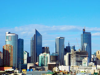 Metro Manila 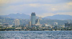 Cebu City |
||
| 1 | Quezon City | 2,679,450 | 2.53% | National Capital Region | |||
| 2 | Manila | 1,660,714 | 0.03% | National Capital Region | |||
| 3 | Caloocan | 1,378,856 | 2.53% | National Capital Region | |||
| 4 | Davao City | 1,363,337 | 1.81% | Davao Region | |||
| 5 | Cebu City | 798,809 | 2.16% | Central Visayas | |||
| 6 | Zamboanga City | 774,407 | 3.54% | Zamboanga Peninsula | |||
| 7 | Antipolo | 633,971 | 5.22% | CALABARZON | |||
| 8 | Pasig | 617,301 | 2.29% | National Capital Region | |||
| 9 | Taguig | 613,343 | 4.07% | National Capital Region | |||
| 10 | Valenzuela | 568,928 | 2.23% | National Capital Region | |||
| based on the Philippines 2007 Census | |||||||