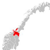
Sør-Trøndelag
| Sør-Trøndelag fylke | |||
|---|---|---|---|
| — County — | |||
|
|||
 |
|||
| Country | Norway | ||
| County | Sør-Trøndelag | ||
| Region | Trøndelag | ||
| County ID | NO-16 | ||
| Official language form | Neutral | ||
| Demonym | Sørtrønder | ||
| Administrative centre | Trondheim | ||
| Government | |||
| - Governor | Kåre Gjønnes Kristelig Folkeparti (1993–present) |
||
| - County Mayor | Tore O. Sandvik Arbeiderpartiet (2003–present) |
||
| Area(#7 in Norway, 5.86% of Norway's land area) | |||
| - Total | 18,848 km2 (7,277.3 sq mi) | ||
| - Land | 17,830 km2 (6,884.2 sq mi) | ||
| Population (2008) | |||
| - Total | 284,773 | ||
| - Density | 15/km2 (38.8/sq mi) | ||
| - Change (10 years) | 5.8 % | ||
| - Rank in Norway | 5 (5.90% of nation) | ||
| Time zone | CET (UTC+01) | ||
| - Summer (DST) | CEST (UTC+02) | ||
| Income (per capita) | 139,200 NOK | ||
| GDP (per capita) | 243,281 NOK (2001) | ||
| National Rank: | 5 (4.23% of nation) | ||
| Website | www.stfk.no | ||
|
|
|||

Sør-Trøndelag is a county in the area Trøndelag in Norway, bordering Nord-Trøndelag, Møre og Romsdal, Oppland and Hedmark. To the west is the Norwegian Sea (Atlantic ocean), and to the east is Sweden. The county is separated into a northern and southern part by Trondheimsfjorden. Slightly over 200 000 of the population lives in Trondheim and its suburbs. The Norwegian dialect of the region is Trøndersk.
Contents |
Name
| Historical populations | ||
|---|---|---|
| Year | Pop. | %± |
| 1951 | 197,687 | — |
| 1960 | 210,545 | 6.5% |
| 1970 | 232,147 | 10.3% |
| 1980 | 243,709 | 5.0% |
| 1990 | 250,344 | 2.7% |
| 2000 | 262,852 | 5.0% |
| 2007 | 278,836 | 6.1% |
| 2008 | 282,993 | 1.5% |
| 2009 | 286,729 | 1.3% |
| Source: SSB.no, Statistics Norway. | ||
The name Sør-Trøndelag was created in 1919. It means '(the) southern (part of) Trøndelag'.
Until 1919 the name of the county was Søndre Trondhjems amt. The meaning of this name was '(the) southern (part of) Trondhjems amt'. (The old Trondhjems amt, created in 1662, was divided in 1804. Trondhjem is the old form of Trondheim.)
See also Nord-Trøndelag
Coat-of-arms
The coat-of-arms is from modern times (1983) - but it has old roots: This was the seal of Gaute Ivarsson, archbishop of Trondheim 1475-1510.
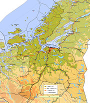
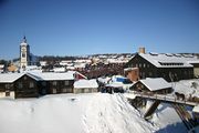
Geography
The broad and long Trondheimsfjord is at the center of this county, although the coastal areas stretch somewhat further north. The mountain ranges Dovrefjell and Trollheimen are located in the south, while the Fosen peninsula is located north of the fjord. Several of the best salmon rivers in Europe are located in the county, the largest and most famous being Gaula and Orkla. Dovrefjell-Sunndalsfjella National Park, Forollhogna National Park, Skarvan og Roltdalen National Park and Femundsmarka National Park are located, or partly located, in the county.[1]
History
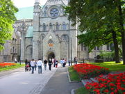
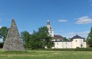
People have lived in this region for thousands of years (see Rock carvings in Central Norway, Nøstvet and Lihult cultures and Corded Ware culture). The fertile lowland bordering the Trondheimsfjord was probably the most important power centre in the Viking Age. Trondheim was the seat of the archbishop for several centuries, and an important pilgrimage destination following the death of St Olav in 1030. Røros, in the southeastern part of the county, is a well-preserved mining town on a mountain plateau, and is a Unesco World Heritage Site.
Economy
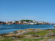
Mining in Røros and Løkken in Meldal lasted for about 300 years, and Thamshavnbanen, the old electric railway from Orkdal to Løkken, is still usable. The constant fires used to crack the rock in the mines demanded vast amounts of firewood; the montane forests on the mountain plateau near Røros still have not fully recovered. Along the coast, fishing has always been important. Farming was and still is important in the whole county, with the most economical important agriculture taking place in the fertile lowland valleys, such as in Melhus, Orkdal, Skaun, Midtre Gauldal, Malvik and Trondheim, but also near the outer seaboard, such as in Ørland and Rissa. The city of Trondheim has always been at the centre of this area, with administrative functions, as well as industry based on agricultural produce, and more recently education, high-tech business and healthcare.
Climate
The weather is very much decided by the direction of the wind; southerlies and easterlies bring sunny weather, while westerlies bring precipitation with mild weather in winter and cool rainy weather in summer. Northwesterlies bring the worst weather with snow in winter (often sleet or rain on the coast). Average yearly precipitation varies from 2,000 mm in some areas of Fosen, to 850 mm in Trondheim and only 500 mm in Oppdal. The interior areas at somewhat higher elevations have cold winters with reliable snow cover, while the coastal areas have a maritime climate with mild and more windy winters. Sula in Frøya municipality has an average of 1.5°C (34°F) in the coldest month.[2] Røros, at an altitude of 628 m (2,000 ft), has a January average of -11.2°C (12°F; [2] Summer temperatures does not differ that much; sheltered lowlands a bit inland will have the warmest summers. Base period 1961-1990.
Municipalities
| Rank | Name | Inhabitants[3] | Area km² |
|---|---|---|---|
| 1 | 170,936 | 324 | |
| 2 | 14,841 | 660 | |
| 3 | 12,550 | 162 | |
| 4 | 11,276 | 567 | |
| 5 | 6,626 | 213 | |
| 6 | 6,603 | 2,207 | |
| 7 | 6,442 | 590 | |
| 8 | 6,012 | 1,817 | |
| 9 | 5,801 | 177 | |
| 10 | 5,576 | 1,764 | |
| 11 | 5,121 | 73 | |
| 12 | 4,548 | 356 | |
| 13 | 4,314 | 230 | |
| 14 | 4,256 | 646 | |
| 15 | 4,207 | 638 | |
| 16 | 4,004 | 1,147 | |
| 17 | 3,929 | 597 | |
| 18 | 3,220 | 900 | |
| 19 | 2,622 | 929 | |
| 20 | 2,064 | 1,177 | |
| 21 | 1,719 | 297 | |
| 22 | 1,033 | 371 | |
| 23 | 999 | 357 | |
| 24 | 998 | 490 | |
| 25 | 859 | 1,221 | |
| Total | 290,547 | 18,848 |
External links
References
- ↑ Trygve B. Haugan, ed. Det Nordlige Norge Fra Trondheim Til Midnattssolens Land (Trondheim: Reisetrafikkforeningen for Trondheim og Trøndelag. 1940)
- ↑ 2.0 2.1 MET.no, kommuner Temperaturnormaler/Nedbørnormaler for Frøya i perioden 1961 - 1990 (Norwegian)
- ↑ Statistisk Sentralbyrå (1. januar 2010). www.ssb.no.
|
|||||||