Yaroslavl
| Yaroslavl (English) Ярославль (Russian) |
|
|---|---|
| — Inhabited locality — | |
 |
|
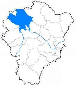
.svg.png) Location of Yaroslavl Oblast in Russia |
|
 Yaroslavl
|
|
| Coordinates: | |
.png) |
 |
| Administrative status | |
| Country | Russia |
| Federal subject | Yaroslavl Oblast |
| Municipal status | |
| Urban okrug | Yaroslavl Urban Okrug |
| Mayor | Viktor Vladimirovich Volunchunas |
| Representative body | City Duma |
| Statistics | |
| Area | 205.37 km2 (79.29 sq mi) |
| Population (2002 Census) | 605,200 inhabitants[1] |
| - Rank | 21 |
| - Density | 2,947 /km2 (7,630 /sq mi)[2] |
| Time zone | MSK/MSD (UTC+3/+4) |
| Founded | 1010 |
| Postal code(s) | 150000—150066 |
| Dialing code(s) | +7 +7 4852 |
| Official website | |
| Historical Centre of the City of Yaroslavl* | |
|---|---|
| UNESCO World Heritage Site | |
 |
|
| State Party | |
| Type | Cultural |
| Criteria | ii, iv |
| Reference | 1170 |
| Region** | Europe and North America |
| Inscription history | |
| Inscription | 2005 (29th Session) |
| * Name as inscribed on World Heritage List. ** Region as classified by UNESCO. |
|
Yaroslavl (Russian: Яросла́вль) is a city in Russia, the administrative center of Yaroslavl Oblast, located 250 kilometers (155 mi) north-east of Moscow. The historical part of the city, a World Heritage Site, is located at the confluence of the Volga and the Kotorosl Rivers. Population: 613,088 (2002 Census);[1] 632,991 (1989 Census).[3]
Contents |
History
Yaroslavl lies at the intersection of several major highways, railways, and waterways. Preceded by Viking sites such as Timerevo from the 8th or 9th centuries, the city is said to have been founded in 1010 as an outpost of the Principality of Rostov Veliky, and was first mentioned in 1071. Capital of an independent Principality of Yaroslavl from 1218, it was incorporated into Muscovy in 1463. In the 17th century it was Russia's second largest city, and for a time (during the Polish occupation of Moscow in 1612), the country's de facto capital. Today, Yaroslavl is an important industrial center (petrochemical plant, tire manufacturing plant, diesel engines plant and many others).
Location
Yaroslavl is located 155 miles (249 km) from Moscow. Many of the roads connecting these cities are two-lane highways.
Main sights
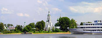
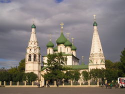
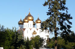
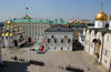
The most ancient building in the city is the Spaso-Preobrazhensky ("Transfiguration of the Saviour") Cathedral of the Spassky (St Saviour) Monastery constructed in 1506—1516 on the foundations of the original edifice dating back to 1216—1224. In the 16th century, the first stone wall is built around the monastery. It is from this monastery that an army of volunteers led by Minin and Prince Pozharsky set out to liberate Moscow from Polish invaders. In 1787, the monastery was closed and converted into a residence of the Yaroslavl and Rostov bishops. At that time, monastery buildings began to be reconstructed. New cells and the prior's chambers were built.
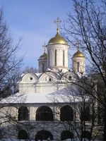
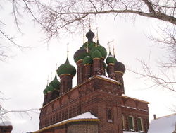
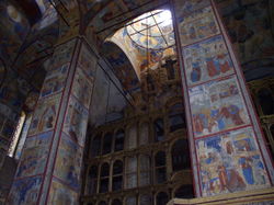
Apart from the Spaso-Preobrazhensky ("Transfiguration of the Saviour") Monastery, the oldest churches in the city date back to the 17th Century and belong to the so-called Yaroslavl type (built of red brick, with bright tiled exteriors). Those of St. Nicholas Nadein and Elijah the Prophet have some of the Golden Ring's most impressive frescoes.
Yaroslavl is the site of the Volkov Theatre (built 1750), the oldest theater in Russia, and the Demidovsky Pillar.
The city has many Russian Orthodox churches, one Russian Old Believers church, one Baptist church, one Lutheran church, one mosque and one synagogue.
Education
Yaroslavl has many institutions for higher education, including Demidov University, Polytechnical University, Ushinskiy Pedagogical University, Medical Academy, Agricultural Academy, International Academy of Business and New Technologies (MUBiNT). Military institutions include the High Military Financial School and the High Anti-Aircraft Missile School.
Transportation
The city has a well-developed network of public transportation, including buses, trolley-buses and tram lines. It is home to the Tunoshna airport, which was a former Cold War airbase, and the Yaroslavl Levtsovo air base.
There is one railway bridge across the Volga and two road bridges; the second road bridge across the Volga was ready for use in October 2006.
There are two major passenger railway stations: Yaroslavl-Glavny and Yaroslavl-Moskovsky. Electric shuttle trains go to Danilov, Rostov, Alexandrov, Nerekhta, and Kostroma. Diesel shuttle trains go to Rybinsk and Ivanovo. Also, many long-distance passenger trains go through Yaroslavl.
Sport
FC Shinnik Yaroslavl is a football club based in Yaroslavl. It plays in the Russian First Division. The city also hosts the Lokomotiv Yaroslavl ice hockey team, which became the champion of Russia in 1996–1997, 2001–2002, and 2002–2003.
Districts
Yaroslavl is divided into six city districts. The center is located on the northern bank of the Kotorosl River, where it converges with the Volga on the Volga's western bank. The center is the economic and political hub of the city. It is also the oldest district in the city and where it was first settled. The center contains the majority of landmarks and attractions in the city, including the Volkov Theater, the Church of Elijah the Prophet, the football stadium,and the Volga embankment and the monastery, which is often mistakenly called the kremlin. Pyatyorka is located north of the center but is still under its administrative jurisdiction. Pyatyorka is largely a residential region with very few notable sites, aside from a few houses of culture.
Across the Kotorosl lie the Frunzensky and Krasnoperekopsky city districts, which are divided by Moskovsky Prospect. Frunzensky is a relatively new district, constructed in the post-war era. It offers little of interest. Most of the buildings are of typical grey Soviet construction. Frunzensky District is divided into three microdistricts: Suzdalka, Dyadkovo, and Lipovaya Gora.
Krasnoperekopsky city district is one of the oldest parts in Yaroslavl. During pre-revolution days, it was home to the bulk of Yaroslavl's industry, and a good deal of industry remains today. Krasnoperekopsky district is divided into two microdistricts, one of which is Neftestroy, an up-and-coming region, named for its proximity to Yaroslavl's oil refinery. Neftestroy is home to the newly built hockey arena, and there are plans to build an indoor football stadium there by the millennial anniversary of Yaroslavl's founding in 2010. On the other side of the railway tracks that run through Krasnopereposk district lies the Perekop proper. Today, the Perekop is known as one of the most dangerous areas of Yaroslavl. It consists largely of run-down, pre-Soviet izbas and decaying factory buildings. There are plans to pump life into this depressed district, but at the time of writing, it remains extremely impoverished and dangerous. Much of Yaroslavl's mafia grew out of the Perekop. However, the Perekop offers some of Yaroslavl's most beautiful parks and churches, most notably the Church of Saint John the Baptist, which is located next to a paint factory on the Kotorosl embankment; and Peter and Paul's Cathedral, a Protestant-style Orthodox church.
North of the center there is a small industrial region, which is home to the tire factory, the engine plant, as well as many other smaller factories. Further north on the Western bank lies Dzerzhinsky city district, named after "Iron" Felix Dzerzhinsky, founder of the Cheka, the Soviet secret police. Dzerzhinsky District's core microdistrict is Bragino, named after a small village that was eventually consumed by Yaroslavl's post-war expansion. Bragino is the largest area in Yaroslavl in terms of population, but like Frunzensky District, it is largely a residential region, mostly consisting of middle- to lower-middle income families.
On the other bank of the Volga lies Zavolzhsky city district (lit. one behind the Volga). Zavolzhsky District was Yaroslavl's quietest and most rural area, but now this district is one of the moust dynamic parts or the city with expansive new buildings with big hypermarkets, such as "Globus" and "Real." Beautiful birch and evergreen forests separate apartment blocks.
Notable residents
- Valentina Tereshkova, the first woman in space, was born in a nearby village and went to school in Yaroslavl.
- Andrei Khomutov, member of the Soviet national hockey team that won countless World Championships and the 1981 Canada Cup.
- Fyodor Volkov, founder of the 1st Russian theatre.
- Nikolai Nekrasov and Leonid Trefolev, poets.
- Leonid Sobinov, opera singer.
- Konstantin Ushinsky, founder of the Russian pedagogics.
- Boris Vinogradsky, MD, FACS, surgeon, now working in Cleveland, Ohio, USA, Chairman of the Board of the Russian American Medical Association
- Elena Grosheva, Olympic Gymnast (Silver Medalist, Atlanta 1996)
- Denis Grebeshkov, Hockey player for the Nashville Predators
- Lyubov Ivanovskaya a Russian triathlete
- Artemy Troitsky, rock critic.
International relations
Twin towns — Sister cities
Yaroslavl has twin town ties with:
References
- ↑ 1.0 1.1 Федеральная служба государственной статистики (Federal State Statistics Service) (2004-05-21). "Численность населения России, субъектов Российской Федерации в составе федеральных округов, районов, городских поселений, сельских населённых пунктов – районных центров и сельских населённых пунктов с населением 3 тысячи и более человек (Population of Russia, its federal districts, federal subjects, districts, urban localities, rural localities—administrative centers, and rural localities with population of over 3,000)" (in Russian). Всероссийская перепись населения 2002 года (All-Russia Population Census of 2002). Federal State Statistics Service. http://perepis2002.ru/ct/html/TOM_01_04_1.htm. Retrieved 2009-08-19.
- ↑ The value of density was calculated automatically by dividing the 2002 Census population by the area specified in the infobox. Please note that this value may not be accurate as the area specified in the infobox does not necessarily correspond to the area of the entity proper or is reported for the same year as the Census (2002).
- ↑ "Всесоюзная перепись населения 1989 г. Численность наличного населения союзных и автономных республик, автономных областей и округов, краёв, областей, районов, городских поселений и сёл-райцентров. (All Union Population Census of 1989. Present population of union and autonomous republics, autonomous oblasts and okrugs, krais, oblasts, districts, urban settlements, and villages serving as district administrative centers.)" (in Russian). Всесоюзная перепись населения 1989 года (All-Union Population Census of 1989). Demoscope Weekly (website of the Institute of Demographics of the State University—Higher School of Economics. 1989. http://demoscope.ru/weekly/ssp/rus89_reg.php. Retrieved 2007-12-13.
- ↑ "Acordos de Geminação" (in Portuguese). © 2009 Câmara Municipal de Coimbra - Praça 8 de Maio - 3000-300 Coimbra. http://www.cm-coimbra.pt/index.php?option=com_content&task=view&id=62&Itemid=128. Retrieved 2009-06-25.
External links
- Yaroslavl Forum in English
- Virtual Panoramas
- Yaroslavl Internet magazine about real life in Yaroslavl (in English)
- Panoramas of Yaroslavl
- Contemporary architecture of Yaroslavl
- Photos
- Volkov theater
- Yaroslavl Millennium project 2010
|
||||||||||||||
|
|||||||
|
|||||||||||||||||||||||||||||
|
|||||||||||||||||||||||||||||||||||
|
||||||||||||||||||||||||||||||||
.jpg)