Agartala
| Agartala | |
| — capital — | |
.JPG) |
|
|
|
|
| Coordinates | |
| Country | |
| State | Tripura |
| District(s) | West Tripura |
| Population • Density |
367,822 (2004[update]) • 6,251 /km2 (16,190 /sq mi) |
| Time zone | IST (UTC+5:30) |
| Area |
58.84 km2 (23 sq mi) • 12.80 metres (42.0 ft) |
| Website | tripura.nic.in |
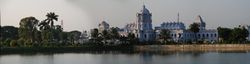
Agartala (Bengali: আগরতলা Agortôla, Kokborok: আগরতলা) is the capital of the Indian state of Tripura. It lies on the Haora River and is located 2 km from Bangladesh. It has several temples and palaces. The population of Agartala was 367,822 in 2004 after the municipal expansion[1] (189,327 in the 2001 census).[2]
Contents |
History
Etymology
?
Foundation
The ancient Capital of the then Princely State ‘Swadhin Tripura’ was at Rangamati (Udaipur, South Tripura) by the bank of the river Gomati and in 1760 A.D., it was shifted by the Maharaja Krishna Kishore Manikya (r.1829-1849) of Manikya Dynasty [3] to present old Agartala by the bank of the river Howrah and was named ‘Haveli’. Due to frequent invasion of the Kuki's and also to keep easy communication with the British Bengal, the Maharaja Krishna Kishore Manikya started the process of shifting the Capital from Old Haveli to New Haveli (present Agartala ) in the year 1849 A.D.
During British Raj, Agartala was the capital of the erstwhile 'Hill Tippera' state, it became a municipality in 1874-75, and in 1901 had the population of 9,513.[4]
Agartala Municipality
The Agartala Municipality was established during the reign of Maharaja Bir Chandra Manikya (1862–1896) within an area of 3 square miles (8 km2) having a population of only 875 by a royal proclamation in the last part of 1871 A.D. Mr. A.W.S. Power, the Ist British Political Agent for Tipperah was also appointed as the Chairman of the Agartala Municipality in the year 1872 A.D. who held office from 1872-73 A.D.
Planned city
Maharaja Bir Bikram Manikya Bahadur is called the founder of the planned City of Agartala. During the period of the early forties, the entire town area was re-organised infrastructurally in a planned manner with strong roads and a market building.
Contemporary history
On October 1, 2008 a series of 5 bomb blasts rocked the city.
Geography and climate
| Agartala | ||||||||||||||||||||||||||||||||||||||||||||||||||||||||||||
|---|---|---|---|---|---|---|---|---|---|---|---|---|---|---|---|---|---|---|---|---|---|---|---|---|---|---|---|---|---|---|---|---|---|---|---|---|---|---|---|---|---|---|---|---|---|---|---|---|---|---|---|---|---|---|---|---|---|---|---|---|
| Climate chart () | ||||||||||||||||||||||||||||||||||||||||||||||||||||||||||||
|
||||||||||||||||||||||||||||||||||||||||||||||||||||||||||||
|
||||||||||||||||||||||||||||||||||||||||||||||||||||||||||||
Agartala is situated in a plain along the Haora River, though the city also extends to the low lying hills on its northern parts.
Agartala has a monsoon influenced humid subtropical climate with high levels of precipitation almost all year. The city experiences long, hot and wet summers, that last from April to October. Average temperatures are around 28 °C (82 °F), fluctuating with rainfall. There is a short, mild winter from mid-November to early March, with mostly dry conditions and average temperatures around 18 °C (64 °F).
Demographics
As of 2001 India census,[5] Agartala had a population of 189,327. Males constitute 50% of the population and females 50%. Agartala has an average literacy rate of 85%, higher than the national average of 59.5%; with 52% of the males and 48% of females literate. 8% of the population is under 6 years of age.
Historical population
In 1941 Agartala had a population of 17,693.[6] By 1991 the population had risen to 157,358.[7]
Growth of the Agartala City at a glance.
| Year | Population | Area |
|---|---|---|
| 1901 | 6,415 | 3 square miles (8 km2) |
| 1911 | 6,831 | 3 square miles (8 km2) |
| 1921 | 7,743 | 3 square miles (8 km2) |
| 1931 | 9,580 | 3 square miles (8 km2) |
| 1941 | 17,693 | 3 square miles (8 km2) |
| 1951 | 42,595 | 3 square miles (8 km2) |
| 1961 | 54,878 | 3 square miles (8 km2) |
| 1971 | 100,264 | 3 square miles (8 km2) |
| 1981 | 132,186 | 10.94 km² |
| 1991 | 157,358 | 15.81 km² |
| 2001 | 188,540 | 16.02 km² |
| 2004 | 367,822 | 58.84 km² |
Neighbourhoods
.JPG)
Agartala city consists of many Paras, which means "locality" in Bengali. Each neighbourhood or para is usually a municipal ward or division also.
Localities
Neighbourhoods of the city include: Krishnanagar, Banamalipur, Math Chowmuhani, Dhaleswar, Pratapgar Area, Kashari patti, Kaman Chowmuni, Radha Nagar, Shibnagar, Ramnagar, Joynagar, Abhoynagar, Radhanagar, Arundhutinagar, Gol Bazaar, Gurkha Basti, Kunjaban, College Tilla, Indranagar, Volagiri, Arundhuti Nagar, Bhati Abhoynagar, 79 Tilla, New Capital Complex, GB, Agartala, Amtali, Badhar Ghat, lake Chowmuni, Ganaraj Chowmuni, Durjoynagar, Bardowali, Bottala, Melarmath etc.
These areas are further subdivided into residential blocks, such as Banamalipur which is divided into North Banamalipur, Madhya Banamlipur, South Banamalipur, etc.
The city is expanding very rapidly and is expected to grow and include many more peripheral towns and municipalities in coming years.
Extensions
From 2004 onwards the Agartala Municipal Council has been further extended taking 16 No.of Grams of Dukli R.D.Block,7 No. of Grams of Mohanpur R.D.Block and 2 No.of Grams of Jirania R.D.Block with area of 42.83 sq.k.m. and 1,78,495 nos.of population in addition to the 16 km² and population of 200,000 in 2001 census.[8][9]
City administration
The Agartala city is managed by the Agartala Municipal Council, AMC, which divides the city into many wards and each ward has an elected ward representative or municipal councillor.
For postal administration also the city is divided into various postal zones.
Municipal wards
| WARD NO. | PARA/LOCATION |
|---|---|
| 1 | Mulla Para, Bitter Ban, Bhati Abhoynagar, Radhanagar |
| 2 | Kunjaban Colony, Ujan Abhoynagar, Sukanta Palli |
| 3 | Shyamali Bazzar, Jagatpur, G.B. Kumari Tilla, Indranagar |
| 4 | Dhaleswar Nutan Palli, Dhaleswar (Part), Chandrapur (Part) |
| 5 | Uttar Banamalipur |
| 6 | Krishnanagar(Part), Banerjee Para, Batkhara Office, Lake Chowmuhani |
| 7 | Krishnanagar (West & South) |
| 8 | Ranjit Nagar, Kalikapur, Rampur, Joynagar (W), Joypur, Ramnagar (North) |
| 9 | Ramnagar (Part), Joynagar (Purba & Madhya) |
| 10 | Ramnagar (South), West Joynagar |
| 11 | Police Quarter Complex, M.B. Tilla, Surjya Para, Mission area, Barman Tilla |
| 12 | Bhattapurkur, Sardar Pukur, Milan Sangha, Bardowali, Kabiraj Tilla, Madhya Para |
| 13 | Melarmath, Battala, Gandhighat, Town Bardowali, Master Para, Rabindra Palli, Office lane |
| 14 | Dim Sagar, Palace Compound, Banamalipur (Part), Santi Para, Khosh Bagan, M.G. Bazar, Madhya Para, Gangail, Krishnagar South |
| 15 | College Tilla (Part), Jagahari Mura, Town Paratapgarh |
| 16 | Shibnagar (Part), Banamalipur (Part), College Tilla (Part) |
| 17 | Shibnagar (East), Dhaleswar(Part), College Tilla (Part) |
Politics
Agartala assembly constituency is part of Tripura West (Lok Sabha constituency).[10]
Economy
The city is the state capital so most of the population is employed in the state & central Government and other Government owned enterprises.
Public sector
List of major PSU's in Agartala are:
- ONGC
- GAIL
- BSNL
Private sector
There is a wide variety of private enterprises also and the main business area of the city Gol Bazaar and Kaman Chowmuhani area which has a huge conglomeration of shops, bazaars, banks, etc.
Major Indian banks serving Agartala are Tripura Grameen Bank, SBI, PNB, UTI Bank, ICICI Bank, Vijaya Bank, Canara Bank, UCO Bank, HDFC Bank, etc.
Although many banks have cropped up in Tripura especially Agartala, the most widely used and the bank with the largest network is the Tripura Grameen Bank. It has the largest number of branches in the state. The major commodities exported from Agartala are tea, rubber and gas/LPG.
Demography and culture
The city mainly consists of Bengalis, and the Bengali language predominates in the city. The main festivals of the city such as Durga Puja and Saraswati puja reflect the influence of the culture of the Bengalis.
There is also a growing population of the native Tripuri people in the city. Agartala is a city of mixed culture which was developed over a period of time through the intense cultural contribution of Tripuri and Bengali communities. Thus it can easily be termed as a city of mixed culture.
Among the native Tripuri festivals, the most famous are Kharchi & Garia Poojas.
Languages
Bengali is the common language spoken in Agartala. Other languages spoken include Kokborok (Tripuri language, Manipuri, Chakma, Nepali, Hindi, and English.
Religion
.JPG)
Hinduism is the dominant religion and there are many temples across the city.
Islam, Christianity and Buddhism are the other religions followed in the city.
The major places of religion are listed below:
Temples
Some prominent temples are:
- Laxmi Narayan Bari temple in Palace Compound.
- Jagannath Temple.
- Ram Thakur's Ashram in Banamalipur.
- Durga Bari Temple in Palace Compound.
Churches
- Agartala Baptist Church, Arundhutinagar, the oldest church in Agartala
- Agartala City Baptist Church, Krishnanagar
- Capital Baptist Church, Gurkhabasti
- City Baptist Church, Melarmath
- Khakotor Baptist Church, Abhoynagar
- St. Joseph's Catholic Church, Durjoynagar
- Presbyterian Church, Shyamali Bazaar
Transport
Road
National Highway 44 connects Agartala to Assam and the rest of India by road. The highways (NH44 , NH 44A) connects Agartala with Silchar (317 km), Guwahati (599 km), Shillong (499 km), Dharmanagar (200 km) and Aizawl (443 km). A bus service also connects it to Dhaka (150 km).
Agartala is well connected by road to other parts of Tripura state. National highway 44 has been extended to the south, thus improving the road connectivity between Agartala & south Tripura. Buses, Jeeps trekkers & SUVs are the most popular public carriers, and cars and vans are usually used for private hire.
The main mode of transport within the city consists of a network of cycle rickshaws, auto rickshaws and buses.
Airport
Agartala is also connected by air, the modernised Agartala Airport connects it to other cities in India. There are direct flight connections to Kolkata, Imphal, Chennai, Delhi, Silchar, Aizwal and Guwahati,and Mumbai
The major Airline Service Providers are Air India, Jet Airways, Indigo Airlines, Kingfisher Airlines, Air Deccan, Paramount Airways etc.
Railways
Agartala has been fully connected to other cities in India w.e.f 28 June 2008.However, the routine rail services to Agartala would start by mid-August after clearance from the railway safety commissioner, said P Shivkumar, general manager (construction) of NFR. The foundation stone for the 119 km Kumarghat-Agartala railway project was laid in 1996 by former prime minister H D Deve Gowda. Agartala is the second capital city (after Guwahati, Assam) in the northeast to be connected to the country's extensive railway network.
Communications
Being the capital of a state Agartala has access to all the modern communications network and infrastructure.
Telecommunications
List of Telecom companies serving Agartala are:
Radio
List of Radio stations:
- AIR
- FM Radio Oo La La
Television
Doordarshan (DD) has a television station in Agartala. NE TV and NE Bangla have production and broadcasting centers in the city.
Newspapers
Many newspapers serve the city and the state. Bengali language media is dominant in the city, A list of the major news publications are:
- Syandan Patrika (Bengali)
- Dainik Arohan (Bengali)
- Dainik Sambad (Bengali)
- Tripura Darpan (Bengali)
- Tripura Times (English)
- Daily Desher Katha (Bengali)
- Manush Patrika (Bengali)
News Websites :
Education
Agartala has a lot of educational institutions, schools and colleges and also a central university.
Universities
- Tripura University
- ICFAI university, Tripura
- IGNOU
Colleges
- National Institute of Technology, Agartala
- MBB College
- Women's College
- Ramthakur College
- Tripura Medical College
- Agartala Government Medical College [1]
- Tripura Institute of Technology
- Agartala Polytechnic College
- Women's Polytechnic
- Regional Institute of Pharmaceutical Sciences And Technology(RIPSAT),Abhoynagar
- Tripura Institute Of Para-medical sciences,Amtali
Prominent schools

- Holy Cross School
- Shishu Bihar Higher Secondary School
- Ramakrishna Mission Vidyalaya, Amtali
- Sri Krishna Mission School,
- Hindi Higher Secondary School
- Kendriya Vidyalaya,Kunjaban
- Kendriya Vidyalaya,Badharghat
- Ramakrishna Vivekananda Vidyamandir
- Shiksha Niketan Higher Secondary School
- Don Bosco
- St. Paul's
- Umakanta Academy
- Boys Budhjong
- Girls Budhjong
- Maharani Tulsibati Girls School
- Netaji Subhash Vidyaniketan
- BaniVidyapith School
- Bhavan's Tripura Vidya Mandir
Young people of Tripura love to obtain higher education. Apart from traditional higher educations like MBBS, B.E, B.Tech,MCA, M.Tech, now-a days young people of this area are obtaining qualifications like CS, CA , Environment Science, Journalism, Training of Air Pilot etc.
Sports
Agartala has a good sporting tradition, with many sports and games being played. Especially favourite is football with its own city football league with clubs from various neighborhoods and localities. Tripura has a state team which plays in the Eastern division of the Ranji Trophy Championship, the National Cricket competition of India.
The main stadiums are the Badarghat Stadium, College Tilla Cricket Stadium and the Umakanta Academy Mini-Stadium.
Tourism
Places of interest
- College Tilla - Maharaja Bir Bikram College, Tripura University buildings, football ground, international cricket stadium, picturesque lush landscapes & serene natural lakes.
- Ujjayanta Palace - Palace of the Tripura kings, now converted to state legislative assembly.
- Jagannath temple — Hindu temple of Vaishnava school of thought.
- Umamaheswar temple — Hindu temple of Shaiva & Shakta schools of thought.
- Venuban Vihar
- Budhha Mandir
- Puratan Agartala
- Malancha Niwas
Parks
- Rabindra Kanan
- Children's Park
- Nehru Park
Museums
- Tripura State Museum at Post Office Chowmuhani.
References
- ↑ Agartala Municipality Statistics, provided by the AMC(Agartala Municipal Council) at the Government of Tripura website
- ↑ Indian Census
- ↑ Genealogy of Tripura Kingdom Queensland University.
- ↑ Agartala The Imperial Gazetteer of India, 1909, v. 5, p. 70.
- ↑ "Census of India 2001: Data from the 2001 Census, including cities, villages and towns (Provisional)". Census Commission of India. Archived from the original on 2004-06-16. http://web.archive.org/web/20040616075334/http://www.censusindia.net/results/town.php?stad=A&state5=999. Retrieved 2008-11-01.
- ↑ Columbia-Lippincott Gazeteer. p. 18
- ↑ Cohen, Saul B.,ed. Columbia Gazeteer of the World (New York: Columbia University Press, 1998) p. 26
- ↑ Agartala Municipality Statistics
- ↑ Agartala Statistics and future outlook
- ↑ "Assembly Constituencies — Corresponding Districts and Parliamentary Constituencies" (PDF). Tripura. Election Commission of India. http://archive.eci.gov.in/Febse2003/background/S23/rptListofAC_Dist_PC.pdf. Retrieved 2008-10-08.
External links
- Bengali Newspaper of Tripura
- About AMC
- Agartala travel guide from Wikitravel
- Agartala Horti Agriculture Government Offices
- Weather statistics at Weather.co.uk
- Agartala on GlobalGuide.Org
- Community web portal for Tripurites in and out of Tripura
- Durga Puja from Agartala
- Agartala Tourism, Tripura, India
|
|||||