Aizawl
Aizawl (population 228,280) is the largest city as well as the capital of the state of Mizoram in India. 26% of the population of Mizoram resides in the city. It is also the storehouse of all important Government offices, State assembly house and civil secretariat. It also enhouses different communities of Mizo people.
Geography
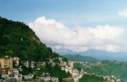
Aizawl is located north of the Tropic of Cancer in the northern part of Mizoram. It is situated on a ridge 1132 metres (3715 ft) above sea level, with the Tlawng river valley to its west and the Tuirial river valley to its east.
Climate
| Aizawl |
| Climate chart () |
| J |
F |
M |
A |
M |
J |
J |
A |
S |
O |
N |
D |
|
|
|
|
|
|
|
|
|
|
|
|
|
| average max. and min. temperatures in °C |
| precipitation totals in mm |
| source: IMD |
|
| Imperial conversion |
| J |
F |
M |
A |
M |
J |
J |
A |
S |
O |
N |
D |
|
|
|
|
|
|
|
|
|
|
|
|
|
| average max. and min. temperatures in °F |
| precipitation totals in inches |
|
Aizawl has a mild, sub-tropical climate due to its location and elevation. Under the koppen climate classification, Aizawl features a humid subtropical climate albeit a more moderate version of the climate. In the summer the temperature ranges from 20-30 degrees Celsius, and in the winter 11-21 degrees Celsius.[1]
Demographics
As of 2001[update] India census,[2] Aizawl had a population of 228,280. Males constitute 50.80% of the population and females made up the remaining 49.20%. Mizos from various tribes make up the majority of the population. Christianity is the dominant religion in the city. Presbyterians make up the majority of the population. However, there are also significant numbers of The Salvation Army, Baptists, Seventh Day Adventists, United Pentecostal Church and Roman Catholics in the city. There are also some cultural based christian sects. Hinduism and Islam are also represented in very small numbers in the city population, primarily from illegal immigrants from other areas of India and Bangladesh.
Transport
Aizawl is connected with Silchar and Shillong by road and there are daily flights from Aizawl to Kolkata and Guwahati.The nearest airport is Lengpui Airport which is about 1 hour drive from Aizawl city. Air India and Kingfisher Airlines are the two regular airlines which operate flights to and from Lengpui Airport.[3] There is also another flight called the North East Shuttle that links the state with the other seven sisters. The Government is also undertaking a project for a helicopter service within the state.
External links
References