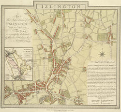
Islington
| Islington | |
 Islington
|
|
| OS grid reference | |
|---|---|
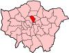
| London borough | Islington |
| Ceremonial county | Greater London |
| Region | London |
| Country | England |
| Sovereign state | United Kingdom |
| Post town | LONDON |
| Postcode district | N1 |
| Dialling code | 020 |
| Police | Metropolitan |
| Fire | London |
| Ambulance | London |
| EU Parliament | London |
| UK Parliament | Islington South and Finsbury |
| Islington North | |
| London Assembly | North East |
| List of places: UK • England • London | |
Islington is the central district of the London Borough of Islington. It is an inner-city district in London, spanning from Islington High Street to Highbury Fields, encompassing the area around the busy Upper Street. The name is now also often applied to the areas of the borough close to Upper Street such as Barnsbury, Canonbury, and De Beauvoir Town, developed in the Georgian era.
Contents |
Modern definition
Islington grew as a sprawling village along the line of the Great North Road and has provided the name of the modern borough. This gave rise to some confusion, as neighbouring districts may also be said to be in Islington. This district is bounded by Liverpool Road to the west and New North Road to the south-east. Its northernmost point is in the area of Highbury. The main north-south high street, Upper Street splits at Highbury Corner to Holloway Road to the west and St. Paul's Road to the east.
The area round Angel tube station is sometimes considered a district in its own right, The Angel, Islington. The northern part of this area (from the Liverpool Road junction northwards) is within the district of Islington, while the southern half is in neighbouring Finsbury. The area below Penton Steet and east of Pentonville Road is the adjoining district of Pentonville.
History
Etymology
Islington was originally named by the Saxons Giseldone (1005), then Gislandune (1062). The name means 'Gīsla's hill' from the Old English personal name Gīsla and dun 'hill', 'down'. The name then later mutated to Isledon, which remained in use well into the 17th century when the modern form arose.[1] In medieval times, Islington was just one of many small manors hereabouts, along with Bernersbury, Neweton Berewe or Hey-bury and Canonesbury (Barnsbury, Highbury and Canonbury - names first recorded in the 13th and 14th centuries).
Origins
Some roads on the edge of the area, including Essex Road were known as streets by the medieval period, possibly indicating a Roman origin, but little physical evidence remains. What is known is that the Great North Road, from Aldersgate came into use in the 14th century, connecting with a new turnpike (toll road) up Highgate Hill. This was along the line of modern Upper Street, with a toll gate at The Angel, defining the extent of the village. The Back Road, the modern Liverpool Road, was primarily a drovers' road where cattle would be rested before the final leg of their journey to Smithfield. Pens and sheds were erected along this road to accommodate the animals.[2]
Islington lay on the estates of the Bishop of London, and the Dean and Chapter of St Pauls. There were substantial medieval moated manor houses in the area, principally at Canonbury and Highbury. In 1548, there were 440 communicants listed, and the rural atmosphere, with access to the City and Westminster, made it a popular residence for the rich and eminent.[1] The local inns, however, harboured many fugitives and recursants.
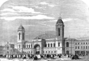
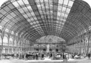
The Royal Agricultural Hall was built in 1862, on the Liverpool Road site of William Dixon's Cattle Layers. The hall was 75 ft high, and the arched glass roof spanned 125 ft. It was built for the annual Smithfield Show in December, but was popular for other purposes, including recitals and the Royal Tournament. It was the primary exhibition site for London until the 20th century, and the largest building of its kind, holding up to 50,000 people.[3] It was requisitioned for use by the Mount Pleasant sorting office during World War II and never re-opened. The main hall has now been incorporated into the Business Design Centre.[4]
Water sources
The hill on which Islington stands has long supplied the City of London with water, the first projects drawing water through wooden pipes from the many springs that lay at its foot, in Finsbury. These included Sadler's Wells, London Spa and Clerkenwell.
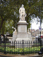
By the 17th century these traditional sources were inadequate to supply the growing population and plans were laid to construct a waterway, the New River, to bring fresh water from the source of the River Lee, in Hertfordshire to New River Head, below Islington in Finsbury. The river was opened on September 29, 1613 by Sir Hugh Myddleton, the constructor of the project. His statue still stands where Upper Street meets Essex Road. The course of the river ran to the east of Upper Street, and much of its course is now covered and forms a linear park through the area.[5]
The Regents Canal passes through Islington. For much of its length, it travels through an 886 metres (2,907 ft) tunnel that runs from Colebrook Row, just east of the Angel, to emerge at Muriel Street, not far from Caledonian Road. The subterranean stretch is marked with a series of pavement plaques, so that canal walkers may find their way from one entrance to the other above ground. The area of the canal east of the tunnel and north of the City Road was once dominated by much warehousing and industry surrounding the large City Road Basin and Wenlock Basin. Those old buildings that survive here are now largely residential or small work units. This stretch boasts one of the few old canal pubs with an entrance actually on the tow-path, The Narrowboat.
The canal was constructed in 1820, to carry cargo from Limehouse into the canal system. There is no tow-path in the tunnel, and bargees had to walk their barges through, braced against the roof.[6] Commercial use of the canal has declined since the 1960s.
Market gardens and entertainments
In the 17th and 18th centuries, the availability of water made Islington a place for growing vegetables to feed London. The manor became a popular resort for Londoners, due to this rural aspect, and many public houses were founded to serve the needs of both visitors and travellers on the turnpike. By 1716, there were 56 ale-house keepers in Upper Street, also offering pleasure and tea gardens, and activities such as archery, skittle alleys and bowling. By the 18th century music and dancing were offered, together with billiards, firework displays and balloon ascents. The King's Head Tavern, now a Victorian building, with a theatre, has remained on the same site, opposite the parish church, since 1543.[4] The founder of the theatre, Dan Crawford, who died in 2005, disagreed with the introduction of decimal coinage. For twenty-plus years after decimalisation (on 15 February 1971), the bar continued to show prices and charge for drinks in pre-decimalisation currency.
By the 19th century, many music halls and theatres were established around Islington Green. One such was Collins' Music Hall, the remains of which are now incorporated into a bookshop. It stood on the site of the Landsdowne Tavern, where the landlord had built an entertainment room for customers who wanted to sing (and later for professional entertainers). It was founded in 1862 by Samuel Thomas Collins Vagg, by 1897 this had become a 1,800 seat theatre with 10 bars. This theatre suffered damage in a fire in 1958, and has not reopened.[4] Between 92 and 162 acts were put on each evening and performers who started there included Marie Lloyd, George Robey, Harry Lauder, Harry Tate, George Formby, Vesta Tilley, Tommy Trinder, Gracie Fields, Tommy Handley and Norman Wisdom.
The Islington Literary and Scientific Society was established in 1833 and first met in Mr. Edgeworth's academy, on Upper Street. Its object was to spread knowledge through lectures, discussions, and experiments, politics and theology being forbidden. A building - the Literary and Scientific Institution - was erected in 1837 in Wellington (later Almeida) Street, designed by Roumieu and Gough in a stuccoed Grecian style. It included a library, with 3,300 volumes in 1839, reading room, museum, laboratory, and lecture theatre seating 500. The subscription was two guineas a year. The library was sold off in 1872 and the building sold or leased in 1874 to the Wellington Club, which occupied it until 1886. In 1885 the hall was used for concerts, balls, and public meetings. The Salvation Army bought the building in 1890, renamed it the Wellington Castle barracks, and remained there until 1955. The building became a factory and showroom for Beck's British Carnival Novelties for a few years from 1956, then remained empty until in 1978 a campaign began to turn it into a theatre. A public appeal was launched in 1981 and a festival of avant-garde theatre and music was held there and at other Islington venues in 1982, and the successful Almeida Theatre founded.[4]
Housing
Some development took place to accommodate the popularity of nearby Sadler's Wells , which became a resort in the 16th century, but the 19th century saw the greatest expansion in housing, soon to cover the whole parish. In 1801, the population was 10,212; by 1891 there were 319,143 inhabitants in the borough. This rapid expansion was partly due to the introduction of horse-drawn omnibuses in 1830. With large well-built houses and fashionable squares, clerks, artisans and professionals were drawn to the district. However, from the middle of the 1800s, the poor were being displaced by clearances in inner London to build the new railway stations and goods yards. They settled in Islington, with the houses becoming occupied by many families. This, combined with the railways pushing into outer Middlesex, reduced Islington's attraction for the better off as it became "unfashionable".[7] The area fell into a long decline; and by the mid-20th century, the area was largely run down and a byword for urban poverty.[1]
World War II caused much damage to Islington's housing stock, with 3,200 dwellings destroyed. While before the war, municipal housing had not had much impact, after the war many bomb sites were redeveloped, both by the Metropolitan Borough of Islington and the London County Council. Clearance of the worst terraced housing was still undertaken, but Islington continued to be both the most dense (least open space), and the borough with the highest level of overcrowding.
From the 1960s, the Georgian terraces were rediscovered by middle class families, and many of the houses were rehabilitated, with the area becoming newly fashionable. This displacement of the poor by the aspirational has become known as gentrification. Among these new residents were a number of the central figures in the New Labour movement, including Tony Blair before his victory in the 1997 general election. "Islington is widely regarded as the spiritual home of Britain's left-wing intelligentsia" (The Guardian).[8] The Granita Pact, between Gordon Brown and Tony Blair, is said to have been made at a, now defunct, restaurant on Upper Street.[9]
The completion of the Victoria line and redevelopment of Angel tube station has created the conditions for developers to build blocks of small flats, popular with young professionals, intensifying use of the area. The inns of the 17th century are now replaced with busy public houses and trendy wine bars. Small shops selling bijou items are increasingly priced out of the area, and replaced by national (and international) chains. Islington remains a place in constant flux.
Monopoly fame
The area is also well-known due to its inclusion in the British version of Monopoly which features The Angel, Islington. However, in the game the Angel is the third cheapest property on the board. 'The Angel, Islington' was included as the licensees considered the names of places they were to use over tea in the Lyon's Corner House, built on the site of the original Angel Inn.
Nearby Monopoly locations are Pentonville Road (mostly within the Borough of Islington) which runs from King's Cross station to The Angel.
The final insult
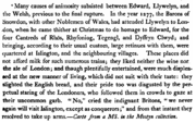
Islington may have played its own small part in the destruction and conquest by England of north Wales. In December 1277 the last native prince of Wales, Llywelyn the Last, while staying in Islington in preparation of his ritual act of homage to the English king, was so heinously offended by the display put on by the locals that he and his lords resolved never to return and thenceforth to fight England to the death.[10]
In literature
Islington features extensively in modern English literature and culture:
- The Diary of a Nobody, an English comic novel written by George Grossmith and his brother Weedon Grossmith. The main character lives on Holloway Road
- Douglas Adams lived in Islington and used it as a setting in his novels, and named a character in his famous Hitchhikers' Guide to the Galaxy series after a well known local estate agents - Hotblack Desiato.
- In Neil Gaiman's best selling novel Neverwhere Islington is an angel that lives under London, named after the Angel tube station.
- Martha Grimes' fictional detective, Richard Jury, lives in a flat in Islington.
- Simon Gray's play Otherwise Engaged is set in Islington. It was written in the 1970s.
- In The Zoo, a comic opera by Arthur Sullivan and B. C. Stephenson, two of the main characters are the Duke of Islington and his beloved, whom he asks to become the Duchess of Islington.
- Nick Hornby's book, and later film, About a Boy are set in Islington.
- Nick Hornby's novel SLAM is set in Islington.
- The film, Notes on a Scandal is set in Islington.
Notable residents, past and present
- This section is solely for residents with a direct link to the area around Upper Street (the centre of Islington); for residents of the London Borough of Islington, or other districts, please see the relevant article. If adding to this list please add a citation explicitly showing the local connection
- Ugo Monye, Harlequins and English rugby union star
- Asa Butterfield, English actor
- Tony Blair, former Prime Minister of the UK, lived on Richmond Crescent in Islington before moving to Downing Street
- Leona Lewis, singer
- Cameron McKenna, Scottish Television Announcer and Radio Broadcaster
- Nadia Almada, first transsexual winner of Big Brother
- Douglas Adams, writer, lived on Duncan Terrace later renting his house to comedian Angus Deayton.
- Adewale Akinnuoye-Agbaje, actor was born here.
- Lily Allen, singer and daughter of actor Keith Allen
- Neal Ascherson, journalist
- Tash Aw, Whitbread Book Award winning author.
- Nina Bawden, Author, has lived in Islington for many years
- James Beck Actor was born here.
- Jay Bothroyd, footballer
- Julian Barratt and Julia Davis, with their twin boys.
- Gary Kemp and Martin Kemp of Spandau Ballet born in Islington lived on Elmore Street N1.
- Kathy Burke Actress, Director lives in Islington.
- Alexandra Burke, Singer and winner of The X Factor 2008
- John Chapple, One of the last Field Marshals of Great Britain and Governor of Gibraltar
- Joe Cole, Footballer for Chelsea FC and England
- Sorcha Cusack, Actress
- Phil Daniels, Actor.
- Alan Davies Actor, Comedian, Radio Presenter, Star of Jonathan Creek and Bob and Rose, etc. lives in Highbury, Islington
- Dido, singer, was born in Islington and owns a property there.
- Colin Firth, actor, is a resident.
- Jonathan Fortune, (Sheffield United F.C Defender was born in Islington).
- Peaches Geldof, celebrity socialite; daughter of Bob Geldof and Paula Yates.
- Kate Greenaway, children's writer and book illustrator, lived on Upper Street for 20 years before moving to Holloway.
- John Glascock, (1951–1979) (musician), bassist of Carmen from 1971–1974 and Jethro Tull from 1975-1979 was born and raised in Islington
- Tony Hadley, lead singer of Spandau Ballet and solo artist, was born in Islington in 1960.
- Edmund Halley, Astronomer Royal and discoverer of Halley's Comet lived in Islington (exact location unknown) from 1665
- Isabel Hilton, journalist and broadcaster
- Boris Johnson MP, Mayor of London
- Charlie G. Hawkins, actor of Darren Miller in EastEnders.
- William Hogarth, artist, was born in Bartholomew Close in 1697 and spent his early years in Islington.
- Yusuf Islam,aka Cat Stevens, musician.
- Ian Jack, writer and journalist.
- Anna Popplewell, actress The Chronicles of Narnia (film series)
- Skandar Keynes, actor The Chronicles of Narnia (film series)
- Danny King (author), wrote The Burglar Diaries and Thieves Like Us (TV series)
- Charles Lamb, writer, lived in Chapel Street from 1796 and later in Colebrook Row.
- Hugh Laurie, actor
- Edward Lear writer, poet, artist, born in Islington
- Heath Ledger Lived in Roman way, Islington while filming his final film in 2007 before his death
- V.I. Lenin lived at 30 Holford Square from 1902 and later at 16, Percy Circus.
- Louise Lombard Actress
- Louisa Lytton, Actress
- Marianne Majerus, photographer
- James McAvoy Actor, Last King of Scotland
- Scott Mills Radio 1 DJ lives here
- Andrew Mitchell, Secretary of State for International Development in the British Government (from May 2010 -)
- Robert Muchamore, author of the CHERUB seires
- Sheree Murphy, actress was born here.
- Edmund John Niemann, 19th century landscape artist.
- Joe Orton, playwright, lived and was murdered in a flat in Noel Road, Islington.
- George Orwell, writer, lived at 50 Lawford Road and in a flat in Canonbury Square.
- Nicky Spesh, rapper, lives in Islington.
- Stephen Poliakoff, award winning playwright.
- Su Pollard Actress, Hi Di Hi
- Jacob Post, religious writer[11]
- Sir Walter Raleigh, writer, poet, courtier and explorer lived in Upper Street between 1575 and 1581.
- Simon Rattle, conductor who lived in Islington for a period
- Linda Robson, actress well known for her role in the television series Birds of a Feather
- Ronnie Ronalde, music hall performer famous for his singing, whistling, yodelling and imitations of bird song was born and raised in Islington. As a young boy, he performed informally in the streets of Islington on a number of occasions.
- Jon Ronson, author, columnist, documentary maker.
- Dana, winner of the 1970 Eurovision Song Contest
- Martin Shaw, actor, who played Ray Doyle and Judge John Deed, etc., lived in Noel Road, including while starring in The Professionals.
- Salman Rushdie, writer who lived in Islington for a period
- Andy Serkis, actor, The Lord of the Rings film trilogy
- Ben Shephard TV Presenter, Lived in Islington 2001-2004
- Sid Smith novelist, journalist, lives in Islington
- Ann Taylor (1782–1866), poet, writer, born in Islington
- Peter Vowell, Schoolteacher, executed for High Treason.
- Charlie Watts, drummer of The Rolling Stones, was born and raised in Islington.
- Frank Warren, boxing promoter, was born in Islington
- Jimmy Carr,Comedian
- Samuel West, actor.
- Kenneth Williams (1926–1988), Actor, Comedian, Radio and Television Entertainer. One of the regulars on the popular Carry On Team, was born in Islington.
- Kate Winslet, actress
- Semothy Jones Songwriter/Record Producer grew up in Holloway.
- Hugo Young, journalist, lived in Milner Square from the late 1960s until the mid 1980s
- John Foxx, electronic musician and first Ultravox singer and frontman, lived there in the 1970s.
- Jonas Grimås, film and television director
- Ed O'Brien, guitarist for the band Radiohead.
- Shana Swash and Joe Swash, actress and actor in Eastenders
- Scott Neal Actor in Beautiful Thing film with actor Glen Berry and also PC Luke Ashton in the Tv Series of The Bill
- Neve Campbell, Canadian actress
- Emma Watson, actress
Transport
The area is well served with bus routes, with a major bus interchange located near Angel tube station. Red route and residents' parking restrictions apply throughout the area.
Nearby places
- Angel
- Barnsbury
- Canonbury
- De Beauvoir Town
- Finsbury
- Highbury
- Hoxton
- Holloway
- Pentonville
- St Luke's
- Shelton Towers Barnsbury
Nearby stations
- Angel tube station
- Essex Road railway station
- Highbury & Islington station
Education
- For education in the area, see the London Borough of Islington article.
Listed buildings
Grade II*
English Heritage[12] lists three Grade II* listed buildings within Central Islington (and many more in surrounding districts):
- The Union Chapel
- 3 Terrett's Place (An 18th-century house on Upper Street)
- St Paul's Church, St Paul's Road (Designed by Sir Charles Barry, now the St Paul's Steiner Project)
Grade II (selected):
The area is perhaps most notable for its houses, shops and pubs. Many whole terraces are listed including much of Liverpool Road (one side of which is in Barnsbury) and Islington High Street/Upper Street. Other multiply listed streets include Camden Passage, Compton Terrace, Colebrooke Row, Cross Street, Duncan Terrace, Essex Road, Gibson Square and Milner Square).
Other Grade II listed structures include:
- The Almeida Theatre.
- The Angel Baptist Church, Cross Street.
- The Angel public house (the original one, now a Co-op bank - not the newer Wetherspoon's), Islington High Street.
- The Business Design Centre (part of which is the former Royal Agricultural Hall), Upper Street.
- The Camden Head public house, Camden Passage.
- The Hope and Anchor public house, Upper Street.
- Ironmonger Row Baths.
- Islington Town Hall.
- M Manze's Pie and Eel Shop, Chapel Market.
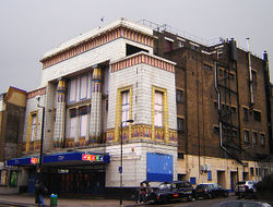
- Mecca Bingo Hall (now closed), Essex Road (once the Carlton Cinema). This is due to become a church in the near future.[13]
- The Old Queen's Head public house, Essex Road.
- St John's Church, Duncan Terrace.
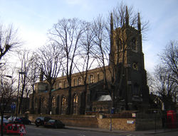
- St Mary's Church, Upper Street (rebuilt after World War 2 - only the spire remains from the original).
- South Library, Essex Road.
- The York public house.
See also
- Almeida Theatre
- Little Angel Theatre
- Business Design Centre
- Crafts Council
- Islington Green
- Market Estate
- The Union Chapel
References
- ↑ 1.0 1.1 1.2 'Islington: Growth', A History of the County of Middlesex: Volume 8: Islington and Stoke Newington parishes (1985), pp. 9-19 accessed: 13 March 2007
- ↑ 'Islington: Communications', A History of the County of Middlesex: Volume 8: Islington and Stoke Newington parishes (1985), pp. 3-8 accessed: 9 March 2007
- ↑ A Vision of Britain - Islington accessed 26 April 2007
- ↑ The Story of the New River (Thames Water) accessed 12 December 2007
- ↑ Alan Faulkner "The Regent's Canal: London's Hidden Waterway" (2005) ISBN 1-870002-59-8
- ↑ Dunton, Larkin (1896). The World and Its People. Silver, Burdett. p. 29.
- ↑ David Clark - "Accusations of anti-Semitic chic are poisonous intellectual thuggery"; Monday March 6, 2006. The Guardian accessed: 9 March 2007
- ↑ Happold, Tom and Maguire, Kevin. "Revealed: Brown and Blair's pact" - The Guardian, 6 June 2003. Accessed 25 December 2005.
- ↑ Parry, Edward (1851). Royal visits and progresses to Wales. p. 135.
- ↑ Charlotte Fell-Smith, ‘Post, Jacob (1774–1855)’, rev. K. D. Reynolds, Oxford Dictionary of National Biography, Oxford University Press, 2004 accessed 19 Jan 2010
- ↑ Images of England accessed: 10 March 2007
- ↑ Islington Gazette (2008-07-09). "Bingo hall gets all-clear to become church". http://www.islingtongazette.co.uk/search/story.aspx?brand=ISLGOnline&category=News&itemid=WeED09%20Jul%202008%2012:32:37:120&tBrand=ISLGOnline&tCategory=search. Retrieved 2008-07-17.
- A History of the County of Middlesex: Volume 8 (Note that even this largely refers to the old parish, considerably larger than the modern district)
External links
London/Islington travel guide from Wikitravel
- Islington Council
- Islington Archaeology & History Society
- Islington Literary & Historical Strolls
- The Islington Society
- St Mary's Church
- Freightliner's Farm
- London Landscape TV episode (5 mins) about Islington
|
||||||||||||||||||||||
|
||||||||