Klaipėda
| Klaipėda | |||
|---|---|---|---|
| — City municipality — | |||
 |
|||
|
|||
| Nickname(s): Uostamiestis (port city) | |||
 |
|||
| Coordinates: | |||
| Country | |||
| Ethnographic region | Lithuania minor | ||
| County | Klaipėda County | ||
| Municipality | Klaipėda city municipality | ||
| Capital of | Klaipėda County Klaipėda city municipality |
||
| First mentioned | 1252 | ||
| Granted city rights | 1254 | ||
| Elderships | Melnragė and Giruliai | ||
| Area | |||
| - Total | 110 km2 (42.5 sq mi) | ||
| Population (2008) | |||
| - Total | 238 000 | ||
| Time zone | EET (UTC+2) | ||
| - Summer (DST) | EEST (UTC+3) | ||
| Website | http://www.klaipeda.lt | ||
.png)
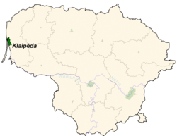
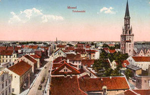
Klaipėda (pronounced [ˈklaɪpeːda](![]() listen); German: Memel) is a city in Lithuania situated at the mouth of the Curonian Lagoon where it flows into the Baltic Sea. It is the third largest city in Lithuania and the capital of Klaipėda County.
listen); German: Memel) is a city in Lithuania situated at the mouth of the Curonian Lagoon where it flows into the Baltic Sea. It is the third largest city in Lithuania and the capital of Klaipėda County.
The city has a complex recorded history, partially due to the strategic regional importance of the Port of Klaipėda, a usually ice-free port on the Baltic Sea. It has been controlled by the Teutonic Knights, the Duchy of Prussia, the Kingdom of Prussia, the German Empire, the Entente States immediately after World War I, Lithuania as a result of the 1923 Klaipėda Revolt, and the Third Reich following the 1939 German ultimatum to Lithuania. The city was incorporated into Lithuania during its tenure as a Soviet Socialist Republic and has remained within Lithuania following its re-establishment as a independent state.
The population shrank from 207,100 in 1992 to 187,442 in 2005. Popular seaside resorts found close to Klaipėda are Nida to the south on the Curonian Spit, and Palanga to the north.
Contents |
Names

The Teutonic Knights built a castle in the *Pilsāts Land of the Curonians and named it Memelburg; later the name was shortened to Memel. From 1252-1923 and from 1939–1945, the town and city was officially named Memel. Due to political changes between 1923 and 1939, both names were in official use; since 1945 the Lithuanian name of Klaipėda is used.
The names Memelburg and Memel are found in most written sources from the 13th century onwards, while Klaipėda is found in Lithuania-related sources since the 15th century. The first time the city was mentioned as Caloypede in the letter of Vytautas in 1413,[1] for the second time in the negotiation documents of 1420 as Klawppeda,[2] and for the third time in the Treaty of Melno of 1422 as Cleupeda. According to Samogitian folk etymology, the name Klaipėda refers to the boggy terrain of the town (klaidyti=obstruct and pėda=foot). Most likely the name is of Curonian origin and means "even ground": „klais/ klait“ (flat, open, free) und „ped“ (sole of the foot, ground).
The lower reaches of the Neman River were named either *Mēmele or *Mēmela by local Curonian inhabitants. It means in the Couronian-Latvian language mute, silent (memelis, mimelis, mēms). This name was adopted by speakers of German and also chosen for the new city founded further away at the lagoon.
History
Teutonic Knights
A settlement of Baltic tribes in the territory of the present-day city is said to have existed in the region as early as the 7th century.
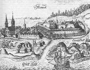
In the 1240s the Pope offered King Håkon IV of Norway the opportunity to conquer the peninsula of Sambia. However, following the personal acceptance of Christianity by Grand Duke Mindaugas of Lithuania, the Teutonic Knights and a group of crusaders from Lübeck moved into Sambia, founding unopposed a fort in 1252 recorded as Memele castrum (or Memelburg, "Memel Castle"). The fort's construction was completed in 1253 and Memel was garrisoned with troops of the Teutonic Order, administered by Deutschmeister Eberhard von Seyne. Documents for its foundation were signed by Eberhard and Bishop Heinrich von Lützelburg of Courland on 29 July 1252 and 1 August 1252.
Master Conrad von Thierberg used the fortress as a base for further campaigns along the Neman River and against Samogitia. Memel was unsuccessfully besieged by Sambians in 1255, and the scattered Sambians submitted by 1259. Memel was colonized by settlers from Holstein, Lübeck and Dortmund, hence Memel also being known at the time as Neu-Dortmund, or "New Dortmund". It became the main town of the Diocese of Curonia, with a cathedral and at least two parochial churches, but the development of the castle became the dominant priority. According to different sources, Memel received Lübeck city rights in 1254[3] or 1258.[4]
In the spring and summer of 1323, a Lithuanian army led by Gediminas came up the Neman and laid siege to the castle of Memel after conquering the town, and devastated Sambia, forcing the Order to sue for a truce in October. During the planning of a campaign against Samogitia, Memel's garrison of the Teutonic Order's Livonian branch was replaced with knights from the Prussian branch in 1328. Threats and attacks by Lithuanians greatly thwarted the town's development; the town and the castle were both sacked by Lithuanian tribes in 1379, while Samogitians attacked 800 workers rebuilding Memel in 1389.
The Treaty of Melno in 1422 stabilized the border between the Teutonic Order and the Grand Duchy of Lithuania for the next 501 years. The rebuilt town received Kulm law city rights in 1475. Memel remained part of what became Prussia and Germany; the border to Lithuania remained unchanged until 1919. It was one of the longest-lasting borders in Europe, and is referred to in the now-unsung first verse of the German national anthem, which describes borders of German-speaking lands: Von der Maas bis an die Memel, referring to the Meuse river in the West and Neman river in the East.
Duchy of Prussia
Against the wishes of its governor and commander, Eric of Brunswick-Wolfenbüttel, Memel adopted Lutheranism after the conversion of Hohenzollern Margrave of Brandenburg Albert of Prussia and the creation of the Duchy of Prussia as a fief of Poland in 1525. It was the onset of a long period of prosperity for the city and port. It served as a port for neighbouring Lithuania, benefiting from its location near the mouth of the Neman, with wheat as a profitable export. The Duchy of Prussia was inherited by a relative, John Sigismund, the Hohenzollern prince-electors of the March of Brandenburg in 1618. Brandenburg-Prussia began active participation in regional policy, which affected the development of Memel. From 1629-1635, the town was occupied by Sweden over several periods during the Polish-Swedish War of 1625-1629 and the Thirty Years' War.
After the Treaty of Königsberg in 1656 during the Northern Wars, Elector Frederick William opened Memel's harbor to Sweden, with whom the harbor's revenue was divided. Prussian independence from Poland and Sweden was affirmed in the Treaty of Oliva in 1660.
The construction of a defence system around the entire town, initiated in 1627, noticeably changed its status and prospects. In November 1678 a small Swedish army invaded Prussian territory, but was unable to capture the fortress of Memel.
Kingdom of Prussia
By the beginning of the 18th century, Memel was one of the strongest fortresses (Memelfestung) in Prussia, and the town became part of the Kingdom of Prussia in 1701. Despite its fortifications, it was captured by Russian troops during the Seven Years' War in 1757. Consequently, from 1757–1762 the town, along with the rest of eastern Prussia, was dependent on the Russian Empire. After this war ended, the maintenance of the fortress was neglected, but the town's growth continued.
Memel became part of the province of East Prussia within the Kingdom of Prussia in 1773. In the second half of the 18th century Memel's lax customs and Riga's high duties enticed English traders, who established the first industrial sawmills in the town. In 1784, 996 ships arrived in Memel, 500 of which were English. (In 1900 there was still an active English church in Memel, as well as a 'British Hotel'). The specialisation in wood manufacturing guaranteed Memel's merchants income and stability for more than a hundred years. During this era it also normalised its trade relations with Königsberg; regional instability had degraded relations since the 16th century.
Memel prospered during the second half of the 18th century by exporting timber to Great Britain for use by the Royal Navy. In 1792, 756 British ships visited the town to transport lumber from the Lithuanian forests near Memel. In 1800 its imports consisted chiefly of salt, iron and herrings; the exports, which greatly exceeded the imports, were corn, hemp, flax, and, particularly, timber. The 1815 Encyclopædia Britannica stated that Memel was "provided with the finest harbour in the Baltic".
During the Napoleonic Wars, Memel became the temporary capital of the Kingdom of Prussia. Between 1807 - 1808, the town was the residence of King Frederick William III, his consort Louise, his court, and the government. On 9 October 1807 the king signed a document in Memel, later called the October Edict, which abolished serfdom in Prussia. It originated the reforms of Karl Freiherr vom und zum Stein and Karl August von Hardenberg. The land around Memel suffered major economic setbacks under Napoleon Bonaparte's Continental System. During Napoleon's retreat from Moscow after the failed invasion of Russia in 1812, General Yorck refused Marshal MacDonald's orders to fortify Memel at Prussia's expense.
German Empire
After the unification of Germany into the German Empire in 1871, Memel became Germany's most northerly city.
The development of the town in the 19th century was influenced by the industrial revolution in Prussia and the attendant processes of urbanisation. Even though the population of Memel increased fourfold during the 19th century, and had risen to 21,470 by 1910, its pace of development lagged in comparison. The reasons for this were mostly political. Memel was the northernmost and easternmost city in Germany, and although the government was engaged in a very costly tree-planting exercise to stabilise the sand-dunes on the Curonian Spit, most of the financial infusions in the province of East Prussia were concentrated in Königsberg, the capital of the province. Some notable instances of the German infrastructure investments in the area included sandbar blasting and a new ship canal between Pillau and Königsberg, which enabled vessels of up to 6.5 m draughts to moor alongside the city, at a cost of 13 million marks.
Owing to the absence of heavy industry in the 1870s and 1880s, the population of Memel stagnated, although wood manufacturing persisted as the main industry. It remained the central point of the Baltic timber-trade. A British Consul was located in the town in 1800; in 1900 a British Vice-Consul was recorded there, as well as a Lloyd's Agent.
By 1900 steamer services had been established between Memel and Cranz (on the southern end of the Curonian Spit), and also between Memel and Tilsit. A main-line railway was built from Insterburg, the main East Prussian railway junction, to St. Petersburg via Eydtkuhnen, the Prussian frontier station. The Memel line also ran from Insterburg via Tilsit, where a further direct line connected with Konigsberg, that crossed the 4 km wide Memel River Valley over three bridges before its arrival in Memel.
During the second half of the 19th century, Memel was a center for the publication of books printed in the Lithuanian language using the Latin alphabet - these publications were prohibited in the nearby Russian Empire. The books were then smuggled over the border into Lithuania.
The German 1910 census lists the Memel Territory population as 149,766, of whom 67,345 declared Lithuanian to be their first language. The Germans greatly predominated in the town and port of Memel as well as in other nearby villages; the Lithuanian population was predominant in the area's rural districts. (EB, 1938 Year Book, see map of languages)
Inter-war years
Under the Treaty of Versailles after World War I, Memel and the surrounding Memel Territory (or Klaipėda Region) was made a protectorate of the Entente States, in order to guarantee port rights to Lithuania and Poland. The territory was administered by an autonomous Landtag government, under a French High Commissioner, with the ultimate intention that it would be a self-governing territory on the model of Danzig.
Lithuania invaded Memel and the Memel Territory in January 1923. Weapons for the Lithuanians were supplied by Germans.[5] Hans von Seeckt, in the name of the Reichswehr, assured that they would not interfere with the Lithuanian intervention in the region.[5] The French garrison made only limited resistance efforts. As this incident occurred on the eve of the French occupation of the Ruhr Area, the Allies had no troops to spare for the restoration of their authority; they consequently took refuge in negotiations which eventually left the juridical sovereignty in the hands of Lithuania. A convention suggested by the League of Nations was signed in Paris on May 8, 1924 securing a measure of autonomy for the inhabitants, (see Gathorne-Hardy). Ratifications of the convention were exchanged in Paris on September 27, 1924. It was registered in League of Nations Treaty Series on October 3, 1924.[6]
The annexation of the city, officially given its Lithuanian name Klaipėda, and the Memel Territory with its large German population, had enormous consequences for the Lithuanian economy. The region subsequently accounted for up to 30% of the Lithuania's entire production, but after economic sanctions which were imposed on the region by the German government in 1933, the economic importance of the region declined.
Animosity between the local Memellanders and the Lithuanians coming to the territory prevented the smooth working of the government. The first Landtag, elected in October 1925, was composed of 27 Germans and two Lithuanians - an indication of the German sympathies of the Memellanders, even those whose native language was Lithuanian. In 1934, 538 German employees were dismissed and 126 Germans were accused of treason before a Lithuanian Military tribunal, after about 1,100 weapons and other illegal materials were found in their possession.[7] Before the election of September 1935, German newspapers were suppressed and four candidates were deprived of Lithuanian citizenship to prevent their election; some 9,000 'new' Lithuanians were given the right to vote. An expropriation edict issued on 6 September 1937 by Lithuanian authorities enabled seizure of German land and public buildings without consultation on the part of local authorities and without adequate compensation.[8]
Opposition by the population to Lithuanian rule continued. The British Foreign Office observed that prior to the Landtag (or Diet) elections on 11 December 1938, the Lithuanian police had been withdrawn and public order had been entrusted to the native German auxiliary police. Lithuanian troops had been confined to their barracks and the sentries removed from the town gates. The elections again displayed an overwhelming majority for the Germans, who then appealed to the German government.
Foreign Minister Joachim von Ribbentrop of Nazi Germany delivered an ultimatum to the Lithuanian Foreign Minister on 20 March 1939, demanding the surrender of the Memel region to German control. The British Consul in Danzig, Mr. Shepherd, reported to Viscount Halifax that "it was generally anticipated that on 25th March the Memel Landtag would vote for the immediate return of Memelland to Germany".[9] Ribbentrop is also claimed to have stated that Memel “will be taken by other means if necessary".[7] Lithuania, however, submitted to the ultimatum and, in exchange for the right to use the new harbour facilities as a Free Port, ceded the disputed region to Germany in the late evening of 22 March 1939; Adolf Hitler had awaited this result on a battleship, sailed into the harbour in the morning hours and made a speech from a theatre balcony (shown in the Ännchen von Tharau photo above). This was Hitler's last territorial acquisition prior to World War 2.
1945-present
During World War II, from the end of 1944 into 1945, as Allied victory appeared imminent, the German inhabitants felt compelled to flee as the fighting drew nearer. The nearly empty city was captured by the Soviet Red Army on 28 January 1945 with only about 50 remaining people. Those who remained were later expelled or killed. After the war the Memel Territory was incorporated into the Lithuanian SSR, marking the start of a new epoch in the history of the city.
The Soviets transformed Klaipėda, the foremost ice-free port in the Eastern Baltic, into the largest piscatorial-marine base in the European USSR. A gigantic shipyard, dockyards, and a fishing port were constructed. Subsequently, by the end of the 1950s, the population of the city had doubled its pre-war population, and by 1989 there were 203,000 inhabitants. In the aftermath of World War II almost all the new residents came to Klaipėda from Russia, Belarus, Ukraine and Lithuania. Initially the Russian-speakers dominated local government in the city, but after the death of Joseph Stalin, more people came to the city from the rest of Lithuania than from other Soviet republics and oblasts; Lithuanians then became its major ethnic group. Among Lithuanian cities with a population greater than 100,000, however, Klaipėda has the highest percentage of people whose native language is Russian.
Until the 1970s, Klaipėda was only important to the USSR for its economy, while cultural and religious activity was minimal and restricted. The developers of a Roman Catholic church (Maria, Queen of Peace, constructed 1957-1962) were arrested. The city began to develop cultural activities in the 1970s and 1980s, such as the introduction of the Sea Festival cultural tradition. Based on the Pedagogical University of Šiauliai and the National Conservatory of Lithuania in Klaipėda, the University of Klaipėda was established in 1991. Klaipėda is now the home of a bilingual German-Lithuanian institution, the Hermann-Sudermann-Schule.
Coat of arms
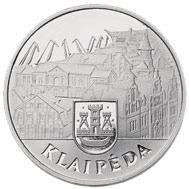
The coat of arms of Klaipėda is also used as coat of arms of Klaipėda city municipality. The modern version was created by the designer Kęstutis Mickevičius. The modern coat of arms was created by restoring old seals of the Memel city (analogous with those used in the years 1446, 1605 and 1618). It was affirmed on July 1, 1992.

Demographics
| Historical populations[10] | ||
|---|---|---|
| Year | Population | |
|
|
||
| 1992 | 207,100 | |
| 1999 | 203,300 | |
| 2003 | 190,906 | |
| 2004 | 189,477 | |
| 2005 | 188,042 | |
| 2006 | 187,316 | |
As of 2007, the population was 185,936. The population by age was: 0-14 14.0%, 15-59 67.1%, 60+ 18.9% There were 85,493 men and 100,443 women in the city. The ethnic composition in 2003 was:
- Lithuanians 63%
- Russians 28.2%
- Poles 4.8%
- Belarusians 0.5%
- Other 3.5%
Of the city's area of 98 square kilometres, 38 % was used for buildings, 1.4% for roads, 8.45% for farming, 14.08% was water, and the remaining 38% was "other uses". Klaipėda contained 17 post offices, a railroad station, a bus station, a harbour, 26 hotels, 4 Catholic chapels,a synagogue, 10 museums, 4 theaters, and 15 sport centers.
City municipality
Klaipėda city municipality council is the governing body of the Klaipėda city municipality. It is responsible for municipality laws. The council is composed of 31 member elected for four-year terms.
The council is the member of the Association of Local Authorities in Lithuania.
Mayors
- 1990–1992 – Povilas Vasiliauskas
- 1992–1994 – Benediktas Petrauskas
- 1994–1995 – Jurgis Aušra
- 1995–1997 – Silverijus Šukys
- 1997–2000 and 2000–2001 – Eugenijus Gentvilas
- 2001–2003, 2003 and since 2007 – Rimantas Taraškevičius
Geography
Climate
Winters are cold to mild, and summers are warm. In July and August, the warmest season, high temperatures average 20 °C (68 °F), and low temperatures average 14 °C (57 °F). In January and February, the coldest season, high temperatures average 0 °C (32 °F) with low temperatures averaging −5 °C (23 °F). It is not uncommon to have temperatures of 30°C (86 °F) in July or −18°C (0°F) in January. Extremes range from 34 °C (93 °F) to −33 °C (−27 °F). The wettest month is November with a mean total precipitation 90 mm. Not only November, but also August, September and October are wet months because of the warmth of the Baltic sea in relation to the continent and the westerly winds. The driest month is February averaging 31 mm of total precipitation. Spring is not particularly wet.
Klaipėda is a windy city with many stormy days per year. In autumn and winter, gales are not unusual. Sea breezes are common from April to September. Snow can fall from October to April and a phenomenon resembling lake-effect snow is frequent. Severe snowstorms can paralyze the city in winter.
Klaipeda has unsettled weather all year round. Winter can be cold and snowy, similar to that in Moscow, while another one can be mild, windy, and rainy, similar to the weather in Scotland. August 2005 was very rainy, while August 2002, barely had any precipitation at all.
Neighborhoods
Klaipėda has 31 neighborhoods:
|
|
|
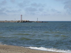
Port of Klaipėda
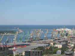
The Port of Klaipėda is the principal ice-free port on the eastern coast of the Baltic Sea. It is the most important Lithuanian transportation hub, connecting sea, land and railway routes from East to West. Klaipėda is a multipurpose, universal, deep-water port. 19 big stevedoring companies, ship-repair and shipbuilding yards operate within the port and all marine business and cargo handling services are being rendered.
The annual port cargo handling capacity is up to 40 Mt. The port operates 24 hours a day, seven days a week, all-year round.
Infrastructure
Notable buildings
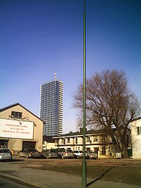
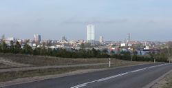
The tallest building in Klaipėda is 34-story Pilsotas. A 40-story commercial building is scheduled to be built in 2012, which would become the tallest building in Klaipėda.
| Name | Stories | Height | Built | Purpose | Status |
|---|---|---|---|---|---|
| Pilsotas | 34 | 111.9 m. | 2007 | Residential | Built |
| BIG 2 Complex | 25 | 72–82 m. | 2009 | Mixed use | Built |
| K Tower | 20 | 71.9 m. | 2006 | Office | Built |
| D Tower | 20 | 71.9 m. | 2006 | Residential | Built |
| Klaipėdos burė | 22 | 66 m. | 2009 | Residential | Built |
| Aukštoji Smeltė | 20 | 66 m. | 2009 | Residential | Under construction |
| Minijos Banga | 20 | 62.2 m. | 2007 | Residential | Built |
| Neapolis Business Centre | 16 | 56.7 m. | 2007 | Office | Built |
| Baltijos Avenue Tower | 15 | 50 m. | 2002 | Residential | Built |
| Vėtrungė | 13 | 42 m. | - | Retail | Built |
Transportation
Klaipėda's public transport is very logical and comfortable for travelling because of its geographical peculiarity the city has expanded along the coast, from north to south. In the beginning of year 2007 a new electronic monthly ticket system was introduced. It is possible to buy an electronic card in shops and newspaper stands and fill it with an appropriate amount of money.
The principal public transport routes in Klaipėda are:
- 3 - From Žvejybos uostas to Klaipėda's north;
- 6 - From south citys microdistrict to Melnragė;
- 8 - From south citys microdistrict to Klaipeda's Railroad Station;
- The special routes 1, 1A, 12, and 19 carry workers to the biggest harbour enterprises.
Klaipėda is being serviced by Klaipėda Airport. Domestic and international commercial scheduled airline services are provided by Palanga International Airport.
Culture and contemporary life
Historical
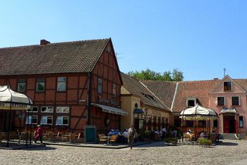
Klaipėda's main attractions are the historic buildings in the city's centre, dating from the 13th to 18th centuries. Some of its older buildings have picturesque half-timbered construction, similar to that found in Germany, France, England, Denmark and southern Sweden. Other places of interest include:
- The remnants of the Klaipeda Castle, built in the 13th century by the Teutonic Order. It had a massive bulk and a quadrangular tower, surrounded by the ramparts and brick bastions. It lost importance after the Russian occupation from 1756 to 1762, and thenceforth started to decay.
- The Žardė ancient settlement, situated on the right bank of the Smiltelė River. It is dated to the late Iron Age (10th century), and was inhabited until the 16th century.
- The remnants of the so-called 'Dutch' defence system around the entire town from the 17th-18th centuries.
- The maritime museum in Fort Wilhelm, built at the end of the 19th century at the spike of the Curonian Spit.
Cinemas
- Cinamon
Theatres
- Klaipėdos Muzikinis Teatras
- Klaipėdos Dramos Teatras
Museums
- Pilies muziejus
- Mažosios Lietuvos istorijos muziejus
- Kalvystės muziejus
- Lietuvos jūrų muziejus ir delfinariumas
- Laikrodžių muziejus
- Kuršių nerijos nacionalinio parko Gamtos muziejus
- Klaipėdos Vytauto Didžiojo gimnazijos gamtos apsaugos muziejus
Festivals
Annual events include Klaipėda Music Spring, the Klaipėda Castle Jazz Festival, Museum Nights, the International Festival of Street Theatres, the International Short Film Festival, and the Klaipėda Sea Festival, among others.[11]
Sports
| Club | Sport | League | Venue |
|---|---|---|---|
| Neptūnas | Basketball | Lithuanian Basketball League (LKL), Baltic Basketball League (BBL) | Neptūnas Hall |
| Nafta-Uni-Laivitė | Basketball | National Basketball League (NKL) | Žalgirio sporto rūmai |
| Atlantas | Football | Lithuanian Football Federation II League (II Lyga) | Žalgiris Stadium |
| Dragūnas | Handball | ||
| Lemminkainen | Basketball | Lithuanian Women Basketball League (LMKL) | |
| Kuršiai | Rugby | Lithuanian Rugby Union I Group | |
| FC Klaipeda | Football | Lithuanian Football Federation I League (I Lyga) | Žalgiris Stadium |
Media
Radio
- Radijas 9 91.4 FM
- Laluna 94.9 FM
- Vox maris 99 FM
- Kelyje 99.8 FM
- Vakarų FM 100.4 FM
- Raduga 100.8 FM
- European Hit Radio 104.1 FM
- Power Hit Radio 96.7 FM
- Zip FM 92.5 FM
Television
- Balticum TV, Analog, Digital
Newspapers
- Vakarų ekspresas
- Klaipėda
- 15 Minučių
Notable residents
- Simon Dach (1605–1659), poet and writer of the Ännchen von Tharau song
- Matthäus Prätorius (1635–1704), Protestant pastor, historian, ethnographer
- Michael Wohlfahrt (1687–1741), religious leader in Pennsylvania
- Friedrich Wilhelm Argelander (1799–1875), astronomer
- Johann Georg Kant (1682–1746), Immanuel Kant's father
- Yisrael Salanter (1810–1883), founder of Musar movement within Judaism
- Isaac Rülf (1831–1902), editor-in-chief of Memeler Dampfboot, philosopher, activist
- David Wolffsohn (1856–1914), second president of World Zionist Organization
- Julius Kröhl (1820–1867), German-American submarine pioneer
- James Hobrecht (1825–1902), city planner
- Rudolf Reicke (1825–1905), philosopher
- Hedwig Andersen (1866–1957), logopedian
- Eduard Kado (1875–1946), artist
- Leon Zeitlin (1876–1967), economist
- George Adomeit (1879–1967), painter
- Charlotte Susa (1898–1976), actress
- Arno Esch (1928–1951) liberal politician in (SBZ) (Soviet Occupied Zone)
- Dietmar Willoweit (born 1936) president of the Bavarian Academy of Sciences
- Tomas Venclova (born 1937), poet and author
- Günter Willumeit (born 1941), comedian
- Lena Valaitis (born 1943), pop singer
- Hans Henning Atrott (born 1944), philosopher and pro-euthanasia activist
- Oleg Kvasha (born 1958), Russian musician and composer
- Leonidas Donskis (born 1962), philosopher and critic
- Tomas Danilevičius (born 1978), Lithuanian football (soccer) player
- Eurelijus Žukauskas (born 1973), European basketball champion
- Saulius Štombergas (born 1973), European basketball champion
- Violeta "Sati" Jurkonienė (born 1976), Lithuanian singer
- Arvydas Macijauskas (born 1980), European basketball champion
- Tomas Vaitkus (born 1982), cycling champion
- Valdas Vasylius (born 1983), basketball player
- Mindaugas Piecaitis born ? , conductor and composer of Catcerto for Nora the Piano Cat
- Tomas Delininkaitis
Sister cities and areas
|
See also
- Ports of the Baltic Sea
References
- Baedeker, Karl. Northern Germany. London, 1904, p. 178.
- Christiansen, Eric. The Northern Crusades. Penguin Books. London, 1997. pp. 107, 160, 248. ISBN 0-14-026653-4
- The Columbia Electronic Encyclopedia (2006).[12]
- Gathorne-Hardy, Geoffrey Malcolm. A Short History of International Affairs, 1920 to 1934. Oxford University Press, 3rd impression, May 1936, p. 89/91.
- Encyclopædia Britannica 1938 Year Book.
- Kirby, David. The Baltic World, 1772-1993: Europe’s Northern Periphery in an Age of Change. Longman. London, 1999. p. 42, 133. ISBN 0-582-00408-X
- Kirby, David. Northern Europe in the Early Modern Period: The Baltic World, 1492-1772. Longman. London, 1990. p. 366 ISBN 0-582-00410-1
- Koch, Hannsjoachim Wolfgang. A History of Prussia. Barnes & Noble Books. New York, 1993. pp. 35, 54, 194. ISBN 0-88029-158-3
- Urban, William. The Teutonic Knights: A Military History. Greenhill Books. London, 2003, pp. 65, 121. ISBN 1-85367-535-0
- Woodward, E.L., Butler, Rohan, (editors). Documents on British Foreign Policy 1919-1939 (1939), Third Series, volume IV. HMSO, London, 1951.
Notes
- ↑ "1413 – pirmąkart paminėtas vardas Klaipėda (Caloypede)"
- ↑ Klaipėda information website
- ↑ Klaipėda city information portal. "History". Retrieved 11 April 2006.
- ↑ Magocsi, Paul Robert. Historical Atlas of Central Europe. University of Washington Press. Seattle, 2002. p. 41. ISBN 0-295-98146-6.
- ↑ 5.0 5.1 Vytautas Kažukauskas. Visa Lietuvių tauta atsiėmė Klaipėdą
- ↑ League of Nations Treaty Series, vol. 29, 86-115.
- ↑ 7.0 7.1 Mažoji Lietuva.Klaipėdos krašto istorijos vingiuose.
- ↑ Encyclopaedia Britannica Year Book, 1939.
- ↑ Woodward, E. L., Butler, Rohan, & Orde, Anne, editors, Documents of British Foreign Policy 1919 - 1939, 3rd series, vol. v, HMSO, London, 1952:25.
- ↑ Gibson, Campbell. Population of the 100 Largest Cities and Other Urban Places in the United States: 1790 to 1990. Accessed October 11, 2005.
- ↑ "CULTURE EVENTS IN KLAIPĖDA 2010 (PART 1)". Klaipėdos turizmo ir kultūros informacijos centras (Klaipeda Tourism and Culture Information Centre). http://www.klaipedainfo.lt/en/index.php?page=7&sub=18. Retrieved 2010-05-25.
- ↑ infoplease.com, Retrieved 11 April 2006.
External links
- Municipal website, klaipeda.lt
- Klaipėda Tourism and Culture Information Center website, klaipedainfo.lt
- Klaipeda tour overview, nwi.ru
- Klaipėda In Your Pocket City Guide (also a downloadable PDF guide), inyourpocket.com
- Klaipeda travel guide from Wikitravel
- Klaipėda State Seaport, portofklaipeda.lt
- University of Klaipėda, ku.lt
- LCC International University, lcc.lt
- Klaipėda on Google Maps, maps.google.com
- History of Memel/Klaipėda by Richard Doody, worldatwar.net
- Memel and the Memelland by the Arbeitsgemeinschaft der Memellandkreise e.V. (German), memelland-adm.de
- Klaipeda for tourists, litauen-netz.de
- wiki-de.genealogy.net, Port of Memel
- All information for tourists about Klaipėda and its area, links, photos, storaantis.lt
|
|||||||||||
|
||||||||||||||||