Piauí
| State of Piauí | |||
|---|---|---|---|
| — State — | |||
|
|||
 |
|||
| Coordinates: | |||
| Country | |||
| Capital and Largest City | Teresina | ||
| Government | |||
| - Governor | Wilson Nunez Martins | ||
| - Vice Governor | |||
| Area | |||
| - Total | 251,529.186 km2 (97,116 sq mi) | ||
| Area rank | 11th | ||
| Population (2005 census) | |||
| - Total | 3,009,190 | ||
| - Estimate (2006) | 3,036,290 | ||
| - Rank | 18th | ||
| - Density | 12/km2 (31/sq mi) | ||
| - Density rank | 18th | ||
| Demonym | Piauiense | ||
| GDP | |||
| - Year | 2006 estimate | ||
| - Total | R$ 12,790,000,000 (23rd) | ||
| - Per capita | R$ 4,213 (27th) | ||
| HDI | |||
| - Year | 2005 | ||
| - Category | 0.703 – medium (24th) | ||
| Time zone | BRT (UTC-3) | ||
| - Summer (DST) | BRT (UTC-3) | ||
| Postal Code | 64000-000 to 64990-000 | ||
| ISO 3166 code | BR-PI | ||
| Website | pi.gov.br | ||
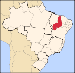
Piauí (Portuguese pronunciation: [piaˈwi]) is one of the states of Brazil, located in the northeastern part of the country.
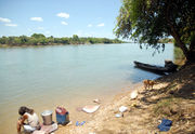
Piauí has the shortest coastline of any of the non-landlocked Brazilian states at 66 km (41 mi), and the capital, Teresina, is the only state capital in the north east to be located inland. The reason for this is, unlike the rest of the area, Piauí was first colonised inland and slowly expanded towards the ocean, rather than the other way around.
In the Southeast of the State, the National Park of Serra da Capivara is a UNESCO World Heritage Site. The park has more than 400 archaeological sites and the largest concentration of rock paintings in the world, in a landscape dominated by canyons and caatinga.
Contents |
History
The state has many highly important archaeological sites, including Serra de Capivara National Park and Sete Cidades National Park, which are rich in remains of prehistoric Amerindian civilisations.
The first settlers in Piauí were bandits fleeing from São Paulo, notably Domingos Afonso Mafrense and Domingos Jorge Velho. Mafrense founded what is today Oeiras, whilst the first herds of cattle were taken there by Velho.
In the 1600s, many impoverished noblemen and Jesuit priests, as well as black and Amerindian slaves, settled there. The first large-scale cattle farming also arrived with these settlers. Large estate owners seeking new pastures for their livestock arrived from neighbouring states such as Bahia and Maranhão.
At the beginning of the 20th century, the principal industry of the state was stock-raising, which dates from the first settlement in 1674 by Domingos Afonso Mafrense, who established here a large number of cattle ranges. A secondary industry was the raising of goats, which were able to stand neglect and a scanty food supply. Agricultural products were cotton, sugar and tobacco. Forest products included rubber, carnauba wax and dyewoods. Exports included hides, skins, rubber, wax, tobacco and cotton.
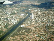
Teresina was the first Brazilian city to be planned. In 1852, an architect designed it, after being inspired by a chessboard. Situated at the mouth of the Parnaíba and Poti Rivers, Teresina was (and still is) known as the Green City because of the countless mango trees that line the city's streets.
Geography
Piauí is bounded on the west by Maranhão, on the east by Ceará, Pernambuco and Bahia, and on the south by Tocantins. It has a short Atlantic coastline on the north.
The Parnaíba River forms the boundary with Maranhão throughout its entire length, the state lies almost entirely within the basin of the Parnaíba and its tributaries. Part of the state on the Atlantic coast and along the lower Parnaíba is low, swampy, and historically malarial. South of this the country rises gradually to a high plateau with open campos. This plateau region is watered by numerous tributaries of the Parnaíba, chief of which are, from south to north: the Poti, which has its source in the state of Ceará; the Longa; the Canindé and its tributary the Piauí, which is navigable for boats of 1 meter draft up to Nova York, a few miles above the mouth of the Gurguéia. The river valleys are separated by flat-topped plateaus called chapadas, including the Serra Uruçui, which lies between the Uruçui-Preto and the Gurguéia, the Serra da Capivara National Park, which lies between the Gurguéia and the Piauí, and the Chapada das Mangabeiras, which forms the southwestern boundary of the state, separating the upper basin of the Parnaíba from that of the Tocantins.
Ecoregions
The sandy soils along the Atlantic coast are home to the Northeastern Brazil restingas, low evergreen forests adapted to the nutrient-poor conditions. The lower basin of the Parnaíba is home to the Maranhão Babaçu forests, which extend westward into Maranhão. This ecoregion dominated by stands of the Babaçu palm.
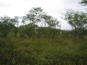
The eastern portion of the state is dominated by the dry Caatingas shrublands, which extend across much of northeastern Brazil. The Cerrado savannas extend across the southwestern portion of the state, in the basins of the upper Parnaíba and Gurguéia rivers. Enclaves of Atlantic dry forests lie in basin of the Gurguéia, forming a transition between the Cerrado and Caatinga. Serra da Capivara National Park is located in the Caatinga of the south-central part of the state, and protects numerous caves with ancient cave paintings.
Climate
The climate is hot and humid in the lowlands and along the lower Parnaíba, but in the uplands it is dry with high day-time temperatures and cool nights.
Demographics
.jpg)
According to the IBGE of 2008, there were 3,164,000 people residing in the state. The population density was 12.1 inh./km².
Urbanization: 60.7% (2006); Population growth: 1.1% (1991–2000); Houses: 791,000 (2006).[1]
The last PNAD (National Research for Sample of Domiciles) census revealed the following numbers: 2,272,000 Brown (Multiracial) people (71.80%), 739,000 White people (23.36%), 145,000 Black people (4.60%), 41,000 Amerindian people (0.47%), 5,000 Asian people (0.17%), 2,000 Amerindian people (0.05%).[2]
Economy
Piaui is one of the poorest states of Brazil[3]. The service sector is the largest component of GDP at 60.1%, followed by the industrial sector at 27.3%. Agriculture represents 12.6%, of GDP (2004). Piauí exports: essential oil 19.5%, soybean 17.1%, woven of cotton 15.1%, cashew 12.6%, crustaceans 12.4%, leather 8.3% (2002).
Share of the Brazilian economy: 0.5% (2004).[4]
Education
Portuguese is the official national language, and thus the primary language taught in schools. But English and Spanish are part of the official high school curriculum.
Educational institutions
- Universidade Federal do Piauí (UFPI) (Federal University of Piauí);
- Universidade Estadual do Piauí (Uespi) (State University of Piauí);
- Centro Federal de Educação Tecnológica do Piauí (Cefet-PI);
- Centro de Ensino Unificado de Teresina (Ceut);
- Centro de Ensino Superior do Vale do Parnaíba (Cesvale);
- and many others.
Culture
Festa Junina (Saint John Festival)
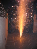
Festa Junina was introduced to Northeastern Brazil by the Portuguese for whom St John's day (also celebrated as Midsummer Day in several European countries), on the 24th of June, is one of the oldest and most popular celebrations of the year. Differently, of course, from what happens on the European Midsummer Day, the festivities in Brazil do not take place during the summer solstice but during the tropical winter solstice. The festivities traditionally begin after the 12th of June, on the eve of St Anthony's day, and last until the 29th, which is Saint Peter's day. During these fifteen days, there are bonfires, fireworks, and folk dancing in the streets (step names are in French, which shows the mutual influences between court life and peasant culture in the 17th, 18th, and 19th-century Europe). Once exclusively a rural festivsl, today in Brazil it is largely a city festival during which people joyfully and theatrically mimic peasant stereotypes and clichés in a spirit of joked and good times. Typical refreshments and dishes are served. Like during Carnival, these festivities involve costume-wearing (in this case, peasant costumes), dancing, heavy drinking, and visual spectacles (fireworks display and folk dancing). Like what happens on Midsummer and St John's Day in Europe, bonfires are a central part of these festivities in Brazil.
Carnival
The four-day period before Lent leading up to Ash Wednesday is carnival time in Brazil. Rich and poor alike forget their cares as they party in the streets.
Infrastructure
National Airport
Teresina/Senador Petrônio Portella Airport. Opened on September 30, 1967, Teresina Airport has been administered by Infraero since February 3, 1975. Teresina Airport is located four kilometers from downtown, roughly a ten-minute trip by car. It is 67 meters above sea level and the local temperature averages 30.9°C (87.62°F).
Highways
BR-020, BR-135, BR-222, BR-226, BR-230, BR-235, BR-316, BR-324, BR-330, BR-343, BR-402, BR-404, BR-407.
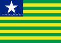
Flag
The flag of Piaui was created on 24 July 1922. The blue canton and a star represents the state itself and the green and yellow bars represent Piauí's union with Brazil. In 2005 the words "13 DE MARÇO DE 1823" were added below the star to commemorate the date of the Battle of Jenipapo, an engagement in Brazil's war of independence.
Cities
Cities in Piaui include:
- Teresina
- Parnaíba
- Picos
- Oeiras
References
- ↑ Source: PNAD.
- ↑ (in Portuguese) (PDF). Piauí, Brazil: IBGE. 2008. ISBN 85-240-3919-1. http://www.sidra.ibge.gov.br/bda/tabela/listabl.asp?z=pnad&o=3&i=P&c=262. Retrieved 2010-01-18.
- ↑ [1]
- ↑ (in Portuguese) (PDF) List of Brazilian states by GDP. Piauí, Brazil: IBGE. 2004. ISBN 85-240-3919-1. http://en.wikipedia.org/wiki/List_of_Brazilian_states_by_GDP_participation. Retrieved 2007-07-18.
![]() This article incorporates text from a publication now in the public domain: Chisholm, Hugh, ed (1911). Encyclopædia Britannica (Eleventh ed.). Cambridge University Press.
This article incorporates text from a publication now in the public domain: Chisholm, Hugh, ed (1911). Encyclopædia Britannica (Eleventh ed.). Cambridge University Press.
See also
- (English) Brazil
- (Portuguese) Official Website
- (English) Piaui Tourism Website
- (English) Brazilian Tourism Portal
- (Portuguese) PiauiHP
- (English) List of cities in Brazil (all cities and municipalities)
|
||||||||||||||||||||||||||||||||||||||
|
||||||||||||||||||||||||||||||||
|
||||||||||||||||||||