Piz Bernina
| Piz Bernina | |
|---|---|
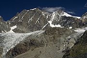
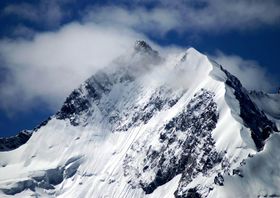 Piz Bernina with the Biancograt to the right |
|
| Elevation | 4,049 m (13,284 ft) |
| Prominence | 2,234 m (7,329 ft) ranked 5th in the Alps |
| Parent peak | Mont Blanc |
| Listing | Canton high point Ultra |
| Location | |
 Piz Bernina
|
|
| Location | Graubünden, Switzerland |
| Range | Bernina |
| Topo map | Swisstopo 1277 Piz Bernina |
| Climbing | |
| First ascent | 13 September 1850 by J. Coaz, J. R. Tschamer and L. R. Tschamer |
| Easiest route | rock/ice climb |
Piz Bernina (4,049 m) is the highest mountain of the Eastern Alps and the highest point of the Bernina Range. It is also the farthest easterly mountain higher than 4,000 m in the Alps, the highest point of the Swiss canton of Graubünden, and the fifth-most prominent peak in the Alps. Piz Bernina is located near St. Moritz, one of the most well-known resorts in the Swiss Alps.
The mountain takes its name from the Bernina Pass and was given in 1850 by Johann Coaz, who also made the first ascent.
Contents |
Geography
Piz Bernina is one of the few isolated four-thousanders in the Alps. It is the culminating point of a group of summits slightly lower than 4000 m mostly lying on the main watershed between Switzerland and Italy (such as Piz Scerscen, Piz Zupò and Piz Palü). The only other summit higher than 4000 m is La Spedla (the Shoulder), a minor prominence south of the mountain, which is also the highest point on the Italian side of the massif.
The summit itself is located on a perpendicular chain (orientated north–south) starting at La Spedla on the border and finishing at Piz Chalchagn, composed also of Piz Morteratsch and Piz Boval.
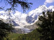
Piz Bernina separates two glacier valleys, the Tschierva Glacier on the west and the Morteratsch Glacier on the east. The waters flowing on both side of the mountain end up in the Inn River. South of Piz Bernina the watershed separates the drainage basins of the Danube (Black Sea) and the Po River (Adriatic Sea). The summit of Piz Bernina is the culminating point of the Danube drainage basin.
Geology
The rocks composing Piz Bernina are diorites and gabbros. The massif in general is also composed of granites (Piz Corvatsch, Piz Palü)[1]. Most of the range belongs to the Austroalpine nappes, a tectonic unit whose rocks come from the Apulian plate, a small continent which broke away from Africa (Gondwana) before the Alpine orogeny. The Austroalpine nappes are common in the entire Eastern Alps.
Climbing history
The first ascent was made via the east ridge in 1850 by the 28-year-old topographer Johann Coaz (from Chur) and his assistants, the brothers Jon and Lorenz Ragut Tscharner. On 13 September 1850, shortly after 6 a.m., they left the Bernina Inn (at 2,050 metres) with their measuring instruments. They traversed the Labyrinth (on the Morteratsch Glacier) and headed to the Fuorcla Crast'Agüzza, a col between the Crast' Agüzza and Piz Bernina. They reached the summit at around 6 p.m.[2]
Johan Coaz wrote in his diary:
- "At 6 p.m. we stood on the ardently desired lofty peak. On soil that no human had trodden upon before. On the highest point of the canton at 4052 meters above sea level."
- "Serious thoughts took hold of us. Greedy eyes surveyed the land up to the distant horizon, and thousands and thousands of mountain peaks surrounded us, rising as rocks from the glittering sea of ice. We stared amazed and awe-struck across this magnificent mountain world." [3]
In 1866, the south ridge running from La Spedla was climbed by Francis Fox Tuckett and F. A. Y. Brown with guides Christian Almer and F. Andermatten. They started at midnight from the Alpe Foppa on the Italian side, and reached the summit at 11 a.m., descending to Pontresina only a few hours later.
The first attempt to climb the northern ridge, the Biancograt, was made on 12 August 1876 by H. Cordier and T. Middlemore with guides J. Jaun and C. Maurer. They successfully reached the top of the ridge, Piz Alv, but when they saw the chasm lying between them and the summit of Piz Bernina, they considered it to be beyond their powers and returned back down the Biancograt.[2] Cordier later declared the gap to be "absolutely impossible".
Exactly two years later, Paul Güssfeldt, accompanied by the guides H. Grass and J. Gross, reached the summit via the Biancograt and accomplished the first complete ascent on this route. The first winter ascent was made on 15 March 1929 by C. Colmus with guides C. and U. Grass. To win a bet worth 200 CHF, Hermann Buhl reached the summit of Piz Bernina from the Boval hut in 6 hours; he then descended the north ridge in only 15 minutes, establishing a record.[2]
Tourism
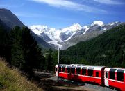
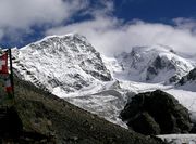
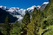
Piz Bernina is the highest summit of the Engadin region and lies close to the resorts of St. Moritz and Pontresina. The mountain can be seen from different viewpoints with the use of ski-lifts from Diavolezza, Piz Corvatsch or Piz Nair. The Bernina Express train connects St. Moritz with the southern Val Poschiavo through the Bernina Pass.
Climbing routes and huts
The normal route starts from the Rifugio Marco e Rosa, located at 3,600 m above the Fuorcla Crast'Agüzza, and follows the route taken by the first ascentionists.
The north ridge, called the Biancograt or Crast Alva (both meaning White Ridge), is the most well-known and attractive route to the summit, and is much more difficult than the normal route. The route starts from the Tschierva Hut (2,584 m) in Val Roseg, accessible from Pontresina. The Biancograt itself starts at the Fuorcla Prievlusa (3,430 m) and leads to Piz Alv (3,995 m). To reach the summit, the Bernina gap – which repulsed Cordier, Middlemore, Jaun and Maurer in 1876 – has to be traversed.
Other huts in the area
- Rifugio Carate Brianza (2,662 m) – capacity 32 beds, 3 places in winter room
- Rifugio Marinelli Bombardieri (2,813 m) – capacity 220 beds, 15 places in winter room
- Chamanna Boval (2,495 m) – capacity 120 beds
- Chamanna da Diavolezza (2,973 m) – capacity 234 beds
- Chamana Boval (2,583 m) - capacity 100 beds
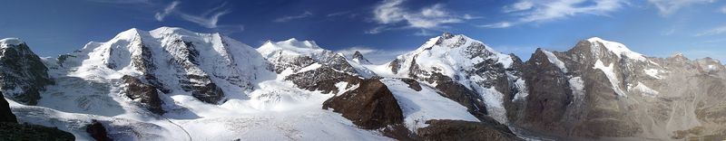
Panorama
Deaths on Piz Bernina
- 1970: Rollo Davidson
See also
- Exploration of the High Alps
References
- Collomb, Robin, Bernina Alps, Goring: West Col Productions, 1988
External links
- Piz Bernina on SummitPost
- Italian route account – Czech/English
- Martin Bundi: Piz Bernina in Romansh, German, French and Italian in the online Historical Dictionary of Switzerland.
|
|||||||||||||||||||||||||||||
|
|||||