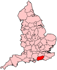
West Sussex
| West Sussex | |
|---|---|
 |
|
| Geography | |
| Status: | Ceremonial & Non-metropolitan county |
| Region: | South East England |
| Area: - Total - Admin. council |
Ranked 30th 1,991 km2 (769 sq mi) Ranked 27th |
| Admin HQ: | Chichester |
| ISO 3166-2: | GB-WSX |
| ONS code: | 45 |
| NUTS 3: | UKJ24 |
| Demographics | |
| Population: - Total (2008 est.) - Density - Admin. Council |
Ranked 27th 781,600 393 /km2 (1,018/sq mi) Ranked 9th |
| Ethnicity: | 96.6% White 1.7% S.Asian |
| Politics | |
 West Sussex County Council http://www.westsussex.gov.uk/ |
|
| Executive: | Conservative |
| Members of Parliament | |
| Peter Bottomley (C) Nick Gibb (C) Nick Herbert (C) Tim Loughton (C) Francis Maude (C) Henry Smith (C) Nicholas Soames (C) Andrew Tyrie (C) |
|
| Districts | |
|
|
West Sussex is a county in the south of England, bordering onto East Sussex (with Brighton and Hove), Hampshire and Surrey. The county of Sussex has been divided into East and West since the 12th century, and obtained separate county councils in 1888, but it remained a single ceremonial county until 1974 and the coming into force of the Local Government Act 1972. Also at this time the Mid Sussex region (including Haywards Heath, Burgess Hill and East Grinstead) was transferred from East Sussex.
West Sussex is a diverse county; it is well known for its stately homes and castles such as Arundel Castle and Bramber Castle. Over half of the county is protected countryside, offering popular walking and cycling ground for visitors and residents alike.[1]
Chichester is the county town of West Sussex, and the highest point of the county is Black Down, at 280m/919 ft (grid reference SU919296).
Contents |
Settlements
Most settlements in West Sussex are either along the south coast or in Mid Sussex, near the M23/A23 corridor. The new town of Crawley and coastal settlement Worthing are the largest in the county, with populations of approximately 100,000 inhabitants each. Next come the seaside resort of Bognor Regis, on the south coast and the market town of Horsham are both large towns. Chichester, the county town, has a cathedral and city status, and is situated not far from the border with Hampshire. Other towns are Burgess Hill, East Grinstead and Haywards Heath in the Mid Sussex district, Littlehampton in the Arun district, and Lancing, Southwick and Shoreham in the Adur district.
Rustington and Southwater are the next largest settlements in the county. There are several more towns in West Sussex, although they are of similar size to other villages. The smaller towns of the county are Arundel, Midhurst, Petworth, and Steyning. The larger villages are Billingshurst, Copthorne, Crawley Down, Cuckfield, Henfield, Hassocks, Hurstpierpoint, Lindfield, Pulborough, and Storrington.
Communications and transport
The M23/A23/A24 runs through the east of the county from Waterloo in London all the way to Brighton and Worthing. Other major roads are the A272 which runs east to west, and the A27 which does the same but closer to the coast, with the A272 going through the middle of the county. Along the majority of the coast the A259 can be found, which is often used as an alternate route to the A27.
Gatwick Airport, which handled over 32 million passengers in 2005, is located to the north of Crawley, and is the second largest airport in the United Kingdom. There is also a considerably smaller local airport at Shoreham. There are 3 main railway routes; the Brighton Main Line, the Arun Valley Line and the West Coastway Line.
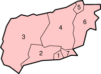
Local government
West Sussex County Council, based at County Hall Chichester, provides a large range of services including education, social services, fire and rescue, libraries, town and country planning, refuse disposal and consumer services. In addition, there are seven local government districts within the county of West Sussex:
- Adur
- Arun
- Chichester
- Crawley
- Horsham
- Mid Sussex
- Worthing
Places of interest
Castles, houses and other buildings
- Arundel Castle
- Barnham Windmill
- Christ's Hospital, an old public school notable for its archaic uniforms and picturesque campus.
- Goodwood House & Goodwood Motor Circuit
- High Salvington windmill
- Hurstpierpoint College - a Public School, notable for its substantial Sussex flint buildings and large campus.
- Lancing College - a Public School, notable for its substantial Sussex sandstone chapel and large campus.
- Petworth House
- Queen Victoria Hospital East Grinstead - Home of the McIndoe burns centre. Pioneered reconstructive surgery for burns patients during the Second World War.
- Sackville College, a Jacobean almshouse in East Grinstead
- Shipley Windmill
- Standen, East Grinstead
- Uppark
- Cobnor House - Home to the Beale Family who were heavily involved with Chichester Harbour
Museums
- Amberley Museum & Heritage Centre
- Steyning Museum[2]
- Tangmere Military Aviation Museum[3]
- Weald and Downland Open Air Museum of historic buildings at Singleton
Nature
- WWT Arundel (a nature reserve of the Wildfowl and Wetlands Trust)
- Selsey Bill
- South Downs Way - a long distance footpath
- Stansted Park
- Wakehurst Place
Ancient history
- Bignor Roman Villa
- Cissbury Ring and Chanctonbury Ring, ancient hill forts located on the South Downs
- Devil's Jumps, a group of Bronze Age burial mounds on the South Downs
- Fishbourne Roman Palace
Religious buildings
- Chichester Cathedral - Anglican cathedral founded in 1075
- Arundel Cathedral - Roman Catholic cathedral
- Bosham Church - home church of Saxon royalty
- Church of St Mary the Blessed Virgin, Sompting - an 11th century Anglo-Saxon church.
- St. Nicholas' Church, Worth - a 10th century church in Worth, Crawley
- Cittaviveka - a Buddhist monastery in Chithurst
See also Category:Churches in West Sussex
The arts
- Pallant House Gallery in Chichester houses one of the most significant collections of 20th century British art outside London. It includes a substantial body of early and mid-20th century work bequeathed by Walter Hussey (Dean of Chichester Cathedral, 1955–1977) and many later works donated by Sir Colin St John 'Sandy' Wilson.
- Worthing Museum and Art Gallery houses the biggest collection of Georgian & Victorian costume in South East England.
Other
- Gatwick Airport
- Shoreham Airport - the world's oldest continually-operational airport.
- Hickstead Showjumping
History
.
Economy
This is a table of trend of regional gross value added of West Sussex at current basic prices published by Office for National Statistics with figures in millions of British Pounds Sterling.[4]
| Year | Regional Gross Value Added[5] |
Agriculture[6] | Industry[7] | Services[8] |
|---|---|---|---|---|
| 1995 | 8,564 | 208 | 2,239 | 6,116 |
| 2000 | 10,576 | 162 | 2,545 | 7,869 |
| 2003 | 12,619 | 185 | 2,520 | 9,915 |
The following are some of the companies based in West Sussex:
- Crawley
- Virgin Atlantic Airways
- British Airways
- AIRMILES
- BOC Edwards
- TUI Travel PLC
- Thales UK
- Burgess Hill
- Roche Diagnostics UK
- Network Technology PLC
- Littlehampton
- The Body Shop
- Dando Drilling
- Inspire Leisure
- Littlehampton Welding Ltd
- Chichester
- Rolls-Royce Motor Cars
- Virgin Vie
- Horsham
- Royal Sun Alliance
- Novartis
- Worthing, Steyning
- Bowers & Wilkins
Education
- To find related topics in a list, see List of schools in West Sussex.
West Sussex has a comprehensive education system, with 36 county-maintained secondary schools, one Academy and over 20 independent senior schools. In addition, primary education is provided through a mix of around 240 infant, junior, primary, first and middle schools.
Politics
West Sussex County Council has 70 councillors; the majority of them being Conservative. There are 47 Conservative councillors, 16 Liberal Democrats, and 7 Labour Party councillors.[9]
As of the 2010 general election, West Sussex is represented entirely by Conservative MPs, after the only Labour Party seat in the county in 2005, Crawley swung to the Conservatives.
- Arundel & South Downs - Nick Herbert, Conservative, 57.8%
- Bognor Regis & Littlehampton - Nick Gibb, Conservative, 51.4%
- Chichester - Andrew Tyrie, Conservative, 55.3%
- Crawley - Henry Smith, Conservative, 44.8%
- Horsham - Francis Maude, Conservative, 52.7%
- Mid Sussex - Nicholas Soames, Conservative, 50.7%
- Worthing East & Shoreham - Tim Loughton, Conservative, 48.5%
- Worthing West - Peter Bottomley, Conservative, 51.7%
See also
- East Sussex
- Sussex
- The Royal Sussex Regiment
- Eastbourne Redoubt Home of the Royal Sussex Regimental Museum
Image gallery
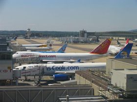 Gatwick's South Terminal |
 Arun Valley at Amberley, West Sussex |
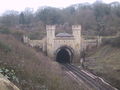 Clayton Tunnel on the London to Brighton line. |
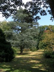
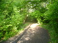 Typical West Sussex woodland at Hassocks. |
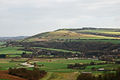
 View of West Sussex from the S Downs above Poynings |
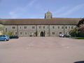 Hurstpierpoint College |
References
- ↑ West Sussex County Council: Leisure & Tourism
- ↑ Steyning Museum
- ↑ : Tangmere Military Aviation Museum | Tangmere Sussex :
- ↑ http://www.statistics.gov.uk/downloads/theme_economy/RegionalGVA.pdf
- ↑ Components may not sum to totals due to rounding
- ↑ includes hunting and forestry
- ↑ includes energy and construction
- ↑ includes financial intermediation services indirectly measured
- ↑ West Sussex County Council: Councillors
- ↑ BBC NEWS | Election 2010 | Election Map
External links
 |
Hampshire | Surrey | Kent | |
| Hampshire | East Sussex | |||
| English Channel | English Channel | English Channel |
|
|||||||||||||||||
|
|||||