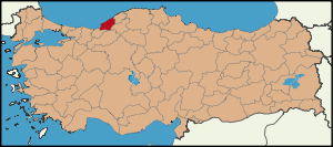
Zonguldak Province
| Location of Zonguldak Province in Turkey | |
|---|---|
 |
|
| Overview | |
| Region: | Black Sea Region, Turkey |
| Area: | 3.481 km2 (1.344 sq mi) |
| Total Population | 558,645 TurkStat 2007 (est) |
| Licence plate code: | 67 |
| Area code: | 0354 |
| Governor Website | http://www.zonguldak.gov.tr |
Zonguldak is a province along the western Black Sea coast region of Turkey. The province is 3.481 km² in size and has a population of 558,645. Its adjacent provinces are Düzce to the southwest, Bolu to the south, Karabük to the southeast, and Bartın to the east. The capital is Zonguldak.
Since the discovery of coal in the province, Zonguldak has become a major coal production center.
Contents |
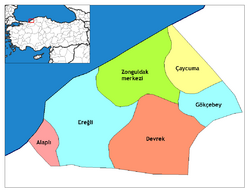
Districts
Zonguldak province is divided into 6 districts (capital district in bold):
- Alaplı
- Çaycuma
- Devrek
- Ereğli (Heraclea Pontica)
- Gökçebey
- Zonguldak
Sites of interest
Ilıksu, Kapuz, Göbü beaches, National Sovereignty Forest, Lake (Göl) Mountain, Plateau, Kocaman, Bostanözü, Çamlık, Baklabostan and Gürleyik forest recreation areas, Cumayanı, Kızılelma, Mencilis caves.
Museums
Ereğli Museum
Address: Atatürk Kültür Sitesi Ereğli - Zonguldak
Tel: (372) 312 03 62
Open Daily except Mondays: 08:00 - 16:30
Ereğli
Ereğli was founded during the 6th century B.C. by the Mariandynians, who were the successors of the Phrygians. Ereğli was an important commercial wharf (emperion), which takes its name from the famous mythic hero, Hercules (Heracles). The city preserved its importance during the Roman, Byzantine, Seljuk, and Ottoman Empire periods. Important historical ruins in the region include the Acheron Valley ruins, in which the Cehennem Ağzı caverns are located, along with Hellenic, Roman, Byzantine and Ottoman ruins, Ereğli Castle, Heracles Palace, Çeştepe Lighthouse tower, Byzantine water cisterns, Krispos mausoleum, Byzantine church and Halil Paşa Mansion.
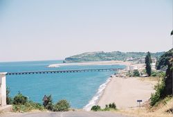
Beaches

Many natural and sandy beaches may be found along a fifty mile (80 km) stretch of the coast. Beginning from the east, these beaches include: Sazköy, Filyos, Türkali, Göbü, Hisararkası, Uzunkum, Tersane, Kapuz, Karakum, Değirmenağzı, Ilıksu, Kireçlik, Armutçuk, Black Sea Ereğli, Mevreke, Alaplı and Kocaman.
Promenade
The boroughs of the city are used as daily recreation areas for leisurely hikes by regional residents. Boroughs are artificial lakes intended to provide drinking water or serve other industrial purposes. These boroughs are: Ulutan Dam Lake at the center, Kızılcapınar Dam Lake, and Gülüç Dam Lake in Ereğli, Dereköy Pond at Çatalağzı borough and Çobanoğlu Pond (18 ha.) at Karapınar borough.
The most important waterfalls of the city are: Harmankaya at Center Kokaksu site, Değirmenağzı at Kozlu borough and Güneşli waterfalls at Ereğli, and their environs are also used for trekking.
Caves
Cehennemağzı, Gökgöl, Kızılelma, İnağzı and Cumayanı are the notable caverns.
National & Natural Parks
- Zonguldak Nature Protection Area
Local Days of Celebration
- April 3 - Anniversary of Ground Breaking for Iron and Steel Works Karabük
- June 4-11 - International Black Sea Ereğli Ottoman Strawberry Culture Festival
- June 11-13 - Festivals: Black Sea Ereğli Culture and Strawberry Festival
- June 21 - Commemoration day for Uzun Mehmet Zonguldak
- June 21-26 - Zonguldak Black Diamond Black Sea International
- July 1 - Maritime Day Ereğli
- July 1 - Cabotage Celebrations
- July 1-31 - International Youths Interchange Program
- July 8-9 - Walking Stick Festival Devrek
- August 26 - Visiting of Atatürk - Commemoration Day
- September 3-9 - 16th Traditional Wrestling
- September 3-9 - Alaplı Hazelnut, Culture, Art and Sports Festival
- November 8 - Commemoration for Uzun Mehmet and Coal Celebrations Ereğli
- December 4-9 - World Miners' Day
- Çaycuma Yogurt Culture & Art Festival Çaycuma
Festivities
- June 18 - Freedom from Occupation Days: Freedom Day - Ereğli
- June 18-24 - Music Feast
- June 21 - Freedom Day
- July 5-7 - Traditional Yenice Wrestling Competitions (Yağlı and Karakucak) Yenice
- July 16-22 - Devrek Walking Stick and Culture Festival
- July 23-29 - Circumcision Feast
- August 26 - Arrival of Atatürk at Zonguldak
- August 31 - September 1 - Traditional Wrestling Festivities Alaplı
- September 3-9 - Circumcision Feast
Coal mining
History
The discovery of coal in the Ereğli (Heraclea) region dates back to the reign of Sultan Mahmud II, and its extraction to Sultan Abdülmecid's reign.
The first specimen of Turkish coal was brought from Ereğli to Istanbul in 1822, but nothing was done for exploration and exploitation of this coal. However, in 1829, another specimen of coal was brought to Istanbul by Uzun (Long) Mehmet, a sailor and native of the village of Kestaneci, near Ereğli. This time attention was given to the discovery and the sailor received a reward of a life pension, but before he could benefit from this reward he was murdered.
The first miners requested and delivered from the Austrian Government are the Austrian Croats known to have been employes in the Ereğli Coal Mines. The correspondence between Istanbul and the embassy in Vienna show that coal production in the Ereğli Basin predates the March 1837 request by 18 months and that production started around September 1835.
An investigation of Hazine-i Hassa (Ottoman Imperial Treasury Department) records in the Ottoman archives shows that regular mining activities in the Ereğli Basin started in February 1841. This is confirmed by a newspaper article published in the 14 February 1841 issue of Ceride-i Havadis.
Ereğli Coal Company, chartered by six partners (Ahmed Fethi Pasha, Rıza Pasha, Safveti Pasha, Tahir Bey Efendi, Izzet Pasha and Mustafa Efendi), excavated the coal in the Ereğli Coal Basin, initially under the auspices of Darphane-i Amire and later transferred to Hazine-i Hassa when the latter was established in 1849.
Timeline of the administration of the Ereğli coal mines after 1845
- 1848-1854 Administration by Hazine-i Hassa
- 1849-1854 English (and Galata goldsmiths) Coal Company’s Management
- 1854-1856 Temporary administration by the English during the Crimean war
- 1856-1861 Administration by Hazine-i Hassa
- 1856-1859 Operated by Trust Administration
- 1859-1860 Operated by Zafiropulos
- 1860-1861 Operated by the English Coal Company
- 1861-1865 Administration by Hazine-i Hassa
- 1865-1908 Administered by the Ministry of Navy
- 1865-1882 Operated by Shipbuilding Administration
- 1882-1940 Operated by local and foreign capital companies
- 1908-1909 Administered by Nafia Nezareti (Ministry of Public Works)
- 1909-1920 Administered by the Ministry of Forestry, Agriculture and Mineral Trade
- 1914-1922 Period of World War I and the National Liberation War
- 1920-1940 Administered by the Ministry of Economics
- 1926-1940 Operated by Türkiye İş Bankası (Ankara)
- 1937-1940 Operated by ETIBANK (Ankara) and EKI
- 1940-1957 Administered by ETIBANK and EKI (Ereğli Komurleri Isletmesi - Zonguldak)
- 1957-1984 Administered by TKI (Ankara)
- 1984-present Administered by TTK (Turkiye Taşkomuru Kurumu - Zonguldak)
In 1851, the Company’s production fields are mentioned in the accounting records as "coal mines administered by the Company under the irade-i seniyye in Ereğli, Amasra and various places". "Various places" mentioned in the records are not known for sure. Records of the period after the Sultan’s participation in the firm mention "coal mines administered by the Company in Bezekli, Amasra, Karaburun areas and various places". (The name Zonguldak did not yet exist in 1851.)
After 1865, one of these "various places" is named as Zone-Goul-Dagh or Zon-Goul-Dak, with mixed Turkish-French pronunciation.
References on internet document of http://www.archivesnationales.culture.gouv.fr/ web site:
- Ports des mines d'Héraclée (19)
- 89 AQ 1703 Documentation et correspondence sur la construction du port de Zongouldak (20). 1893-1896
- 89 AQ 1704 Etudes et projets des ports de Zongouldak et de Koslou par A. Guérard. 1891-1897
- 89 AQ 1705 Projet du port de Zongouldak. 1897
- 89 AQ 1706 Projet du port de Zongouldak. 1897-1898
- 89 AQ 1707 Projet du port de Zongouldak. 1898-1899
- 89 AQ 1708 Arbitrage entre la Société des ports d'Héraclée et la Compagnie de Fives-Lille (21). 1898
Zone-Goul-Dagh was born as a port town of east Ereğli Coal Mines. Its name was probably given by miners/administrators who speak French. (Société d'Héraclée !?) (Probably, the first name of the town was "Sea Port of Zone-Goul-Dagh"... Because, Goul mountain is about 2-3 kilometers far from sea side...)
Coal mining today
- Current coal mining/extraction zones of Zonguldak province/region
- Armutçuk (Ereğli), Kozlu (Kozlu), Üzülmez (Zonguldak), Çaydamar (Zonguldak), Baştarla (Zonguldak), Kilimli (Kilimli), Karadon (Kilimli-Çatalağzı), Gelik (Çatalağzı), Amasra (Amasra, Bartın Province)
- Coal washing/treatment plants
- Zonguldak and Çatalağzı Coal Treatment Plants.
- Coal transport (delivery and import)
- Ports: Zonguldak Sea Port (transport to Ereğli and Istanbul direction), Amasra Port, Ereğli Port
- Other usable port for mine transport: Bartın Port (coal, cement etc.)
- Railway: Zonguldak-Ankara Railway (transport to Karabük and Ankara direction)
- Thermic power plants
- Çatalağzı Thermoelectric Power Plant units (use coal powder), in Işıkveren ward.
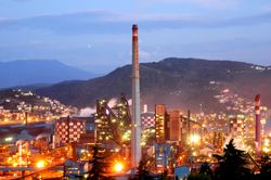
- Iron-steel plants
- Ereğli (Erdemir) Iron and Steel Works, Karabük (Kardemir, Karabük province) Iron and Steel Works.
- Average heat capacity of Zonguldak coals
- 7000 kcal/kg.
Mining disasters
Several mining disasters have occurred in the Zonguldak mines:
- 1992: A gas explosion killed 270 workers. This was Turkey’s worst mining disaster.[1]
- 2008: In a mine collapse, one miner died.[1][2]
- 2010: In the 2010 Zonguldak mine disaster, an explosion in the state-operated Karadon mine, at least 28 miners were killed.[3]
See also
- Erdemir
External links
- (Turkish) Zonguldak governor's official website
- (Turkish) Zonguldak municipality's official website
- (English) Zonguldak weather forecast information
References
- ↑ 1.0 1.1 Gökçen Yüksel (August 27, 2008). "One missing in mine collapse in Zonguldak". Today's Zaman. http://www.todayszaman.com/tz-web/detaylar.do?load=detay&link=151350&bolum=101. Retrieved May 20, 2010.
- ↑ "30 saat sonra sağ çıkarıldı..." (in Turkish). Eriğli Demokrat. August 26, 2008.
- ↑ Ivan Watson and Yeşim Cömert (May 20, 2010). "Bodies of 28 trapped Turkish miners found". CNN.com. http://edition.cnn.com/2010/WORLD/europe/05/20/turkey.miners/. Retrieved May 20, 2010.
|
||||||||||||||||||||||||||||||||||
|
|||||||