Bury
| Bury | |
.jpg) Bury Town Hall |
|
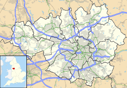 Bury
|
|
| Population | 60,718 |
|---|---|
| OS grid reference | |
| Metropolitan borough | Bury |
| Metropolitan county | Greater Manchester |
| Region | North West |
| Country | England |
| Sovereign state | United Kingdom |
| Post town | BURY |
| Postcode district | BL9 & BL8 & BL0 |
| Dialling code | 0161/01706/01204 |
| Police | Greater Manchester |
| Fire | Greater Manchester |
| Ambulance | North West |
| EU Parliament | North West England |
| UK Parliament | Bury North |
| List of places: UK • England • Greater Manchester | |
Bury (pronounced /ˈbɛrɪ/, locally also /ˈbʊrɪ/) is a town in Greater Manchester, England.[1] It lies on the River Irwell, 5.5 miles (8.9 km) east of Bolton, 5.9 miles (9.5 km) west-southwest of Rochdale, and 7.9 miles (12.7 km) north-northwest of the city of Manchester. Bury is surrounded by several smaller settlements which together form the Metropolitan Borough of Bury, of which Bury is the largest settlement and administrative centre.
Historically a part of Lancashire, Bury emerged during the Industrial Revolution as a mill town centred on textile manufacture.
Bury is regionally notable for its open-air market - Bury Market - and its popularity has been increased since the introduction of the Manchester Metrolink tram system, which terminates in the town. The market is known for its supply of a local traditional dish - black pudding, served hot or cold and can be eaten either as a takeaway snack, or more commonly as an accompaniment or main ingredient of a meal starter or main course.
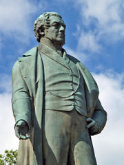
One of Bury's most famous residents was Sir Robert Peel, Prime Minister of the United Kingdom and founder of the Metropolitan Police Service. A monument to Peel is outside Bury parish church and another, the austere Peel Monument, stands on a hill overlooking the locality.
Contents |
History
Toponymy
The name Bury, (also earlier known as "Buri" and "Byri") comes from an Old English word, meaning "castle", "stronghold" or "fort", an early form of modern English borough.[2]
Early history
Bury was formed around the ancient market place but even prior to this there is evidence of activity dating back to the period of Roman occupation. Bury Museum has a Roman Urn containing a number of small bronze coins dated for AD 253-282 and found north of what is now the town centre.[3] Under Agricola the road building programme included a route from the fort at Manchester (Mamucium) to the fort at Ribchester (Bremetennacum) that ran through Radcliffe and Affetside. The modern Watling Street, that serves the Seddons Farm estate on the west side of town, follows the approximate line of the route.
The most imposing early building in the town would have been Bury Castle,[4][5] a medieval fortified manor house. The castle was built in 1469 by Sir Thomas Pilkington, lord of the manors of Pilkington and Bury and a powerful member of Lancashire's gentry. It sat in a good defensive position on high ground over looking the Irwell Valley. At that time the Pilkingtons had been lords of Bury for nearly a century, having inherited the manor from a family named de Bury.
.jpg)
The Pilkington family suffered badly in the Wars of the Roses when, despite the geography they supported the House of York. When Richard III was killed in the Battle of Bosworth, in 1485, Thomas Pilkington was captured and later executed. The outcome of the battle was that the Duke of Richmond, representing the House of Lancaster was crowned Henry VII by Sir William Stanley. As a reward for the support of his family Thomas Stanley was created Earl of Derby and amongst other land the confiscated Pilkington estate in Bury was presented to him.[3]
The ancestral home of the Earls of Derby is Knowsley Hall on the outskirts of Liverpool. The family maintain a connection with Bury in various ways - the Derby High School is named after them. When the school opened in 1959 the Earl of Derby was patron and the school's badge is based on the Earl's coat of arms.
For many years the castle remains were buried beneath the streets outside the Castle Armoury. From time to time it was the subject of archaeological excavations. These established that there was an earlier manor house on the site. In 2000 the castle site was properly excavated as a focal point in the town centre. The remains of the old walls are now displayed in Castle Square.
Between 1801 and 1830 the population of the town more than doubled from 7072 to 15086. This was the time when the factories, mines and foundries began to dominate the landscape with their spinning machines and steam engines.
Industrial Revolution
Probate evidence from the 17th century and the remains of 18th century weavers' cottages in Elton, on the west side of Bury, indicate that domestic textile production was an important factor of the local economy at a time when Bury's textile industry was dominated by woollens and based upon the domestic production of yarn and cloth as well as water-powered fulling mills.[6][7]
Development was swift in the late 18th and early 19th centuries. The establishment of Brooksbottom Mill, in Summerseat north of the town, as a calico printing works in 1773 by the family of Sir Robert Peel marked the beginning of the cotton industry in Bury. By the early 19th century cotton was the predominant textile industry with the River Roch and River Irwell providing power for spinning mills and processing water for the finishing trades. Development was further promoted when the town was linked to the national canal network by the Manchester Bolton & Bury Canal, fully opened in 1808. The canal is provided with water from Elton Reservoir, fed by aqueducts from a weir on the River Irwell, north of what is now the Burrs Country Park. The Burrs is also the site of another mill developed by the Peel family, first founded in 1790. The remains are displayed for the public. There were seven cotton mills in Bury by 1818 and the population grew from 9,152 in 1801 to 58,029 in 1901.
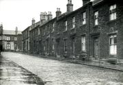
Following this, railways opened, linking the town from Bury Bolton Street railway station to Manchester, Radcliffe, Rawtenstall and Accrington and from the old Knowsley Street railway station to the neighbouring mill towns of Bolton, Heywood and Rochdale. As well as the many cotton mills other industries which thrived included paper–making, calico printing and some light engineering. The town expanded to incorporate the former townships of Elton, Walmersley and Heap and rows of terraced housing encircled the town centre by the turn of the 19th century. Districts such as Freetown, Fishpool and Pimhole were transformed from farmers' fields to rows of terraced housing, beside the factories and mills.
The houses were of the most limited kind without basic facilities, sewers or proper streets. The result was the rapid spread of disease and high mortality rates in crowded areas. In 1838 out of 1,058 working class houses in Bury investigated by the Manchester Statistical Society 733 had 3-4 people in each bed, 207 had 4-5 and 76 had 5-6.[8] Social reformers locally and nationally were concerned about such issues, including Edwin Chadwick. One report that prepared the ground for the reform of public health matters, commissioned by then Prime Minister, Sir Robert Peel, asked local doctors for information. King Street, Bury was highlighted. It had 10 houses, each with one bedroom, and a population of 69. The average age of death in Bury was 13.8 years. Towns like Bury were likened to 'camps'[9] where newcomers sought work in mill, mine or forge. Many, often from Ireland found shelter in lodging houses. 38 in Bury were surveyed.[10] 73% had men and women sharing beds indiscriminately, 81% were filthy and the average was 5.5 persons to a bed.
Although Bury had few of the classic late 19th century spinning mills that were such a feature of other Lancashire towns a group, known as Peel Mills, are still in use at Castlecroft Road, immediately north of the town centre, their name another reminder of the link with the Peel family.
Lancashire Fusiliers
According to writer Geoffrey Moorhouse, a history of Bury is not complete without reference to its role as the regimental town of the Lancashire Fusiliers.[11]
In 1688 Prince William of Orange (later King William III) landed at Brixham, Devon. He was met by a number of noblemen who were then commissioned to raise Regiments to help him oppose James II. Colonel Sir Robert Peyton raised a Regiment containing six independent companies in the Exeter area. In 1782 the title was changed to the XX or East Devon Regiment of Foot and from 1 July 1881 became the XX The Lancashire Fusiliers. The link with Bury and the Fusiliers started at this time when, following successful recruiting in Lancashire a Regimental Depot was established in Bury, Wellington Barracks, in 1881. Wellington Barracks became XX The Lancashire Fusiliers Regimental Headquarters in 1961.
The regiment has been involved in many campaigns and peace keeping duties including the Jacobite uprising, the American War of Independence, the Napoleonic Wars, the Indian Mutiny and both world wars. Since moving to Bury the Lancashire Fusiliers were part, in 1898, of the force that relieved Khartoum and fought in the Battle of Omdurman and in 1899–1902 during the Boer War took part in the battles of Spion Kop and the Tugela Heights, leading up to the Relief of Ladysmith.
In 1914 the regiment was 4th Battalion of the British Expeditionary Force, the first force to enter France against the Germans. On 24 April 1915 the taking of W beach at Gallipoli six men were each awarded the Victoria Cross. The six were chosen by their comrades for the 'action before breakfast'.
The losses in the Dardanelles had a sharp impact on the town. They were all the more pronounced because many of those killed and wounded were from the regiment's Territorial Battalion based in the town. Like the Pals battalions, it recruited from a small area. It also comprised largely of part-time soldiers who had volunteered for regular service at the outbreak of war and who therefore had strong community ties. They were literally, the local butcher, baker and candlestick maker - who had wives and children resident in the town.
As a consequence, for many years afterwards Gallipoli Day was as much a part of the town's mourning for the Great War dead as Armistice Day or latterly Remembrance Sunday.
During World war II the regiment fought at the Battle of Monte Cassino, where Fusilier Jefferson won a VC in July 1943. They were also involved in the D-Day landings, with a successful attack on Villers-Bocage in July 1944. Subsequently they were involved in Burma, at the Suez Canal and Kenya at the time of the Mau Mau rebellion.
In 1968 four fusiliers regiments, the Lancashire, Royal Northumberland, Royal Warwickshire and Royal Fusiliers were amalgamated to create the Royal Regiment of Fusiliers. The bringing together of the various regiments saw the demise of the Lancashire regiment's distinctive primrose hackle - the yellow feathers worn above the cap badge. In its place all the battalions adopted the red and white emblem of the Northumberland Fusiliers who were the senior (oldest) regiment to be absorbed into the newly created Royal Regiment of Fusiliers. After the end of national service, with less need to recruit and train soldiers most of Wellington Barracks was redeveloped for housing and playing fields. Parts of the perimeter wall are still visible but the only part of the site still in military use is the Regimental Headquarters and social club. Sited in Elton on the west side of Bury the barracks fronted Bolton Road, the A58 at the corner with Haig Road. This and other local streets in the estate opposite, including Kitchener, Connaught, White, Buller and Powell Streets were named after prominent army figures.
A memorial to the Lancashire Fusiliers who died in the First World War was placed at the front of the former barracks. Designed by Edwin Lutyens, architect of the Whitehall cenotaph, the memorial is a grade 2 listed monument. Because his father and great uncle had been officers in the regiment Lutyens declined a fee for his work. The monument, 5.88 m high and built of Portland stone, was unveiled in April 1922.[12] In 2009, and after some local controversy, the memorial was moved to Bury town centre where in now stands adjacent to a new regimental museum.
In 1859, the 8th Lancashire (Bury) Rifle Volunteer Corps was formed and a new drill hall was proposed. In 1868 the drill hall, or Castle Armoury, was built on the historical site of Bury Castle. To reflect the 'castle' the drill hall has a fortified style with castellations, gargoyles, turrets, towers, arrow slits and other Norman architectural features on the façade. Above the main gate, with a large semi-circular arch, is a large coat of arms incorporating the Lancashire Fusiliers' badge and motto "Omnia Audax", translating to "Dare Anything". Three plaques on the east wall of the drill hall commemorate those who fell in two world wars and the Boer War.
A platoon of Fusiliers still resides at Castle Armoury. It is also HQ East Lancashire Wing of the Air Training Corps and the Bury Detachment of the Manchester Army Cadet Force and accommodates G Squadron of 207 (Manchester) Field Hospital (Volunteers).
Recent history
In the post-war period, there was a major decline in the cotton industry, and in common with many neighbouring towns, Bury's skyline was soon very different, with countless factory chimneys being pulled down and the associated mills closing their doors forever. The old shopping area around Princess Street and Union Square was demolished in the late 1960s, and a concrete precinct emerged to replace it. This development was replaced by the Mill Gate Shopping Centre in the late 1990s.
Another large shopping area is located around The Rock. The main street is populated mainly by pound shops and charity shops and it also contains a McDonalds. At the top end of the street, however, is a modern shopping area which has formed Bury's New Town. It has a multi screen cinema, bowling alley and department stores including Marks & Spencer and Primark.
Bury has also benefited from other facilities in the early 2010s including a new medical centres and a Premier Inn hotel close to Bury Town Hall. Bury is competing as a destination with Bolton and Rochdale. A decision by Marks and Spencer to vacate its store in the Mill Gate Shopping Centre and move into a large new one on The Rock emphasised a change in the makeup of the town.
The town centre is still famous for its traditional market, with its "world famous" black pudding stalls. Bury Market was also once famous for its tripe, although this has declined in the past few decades.
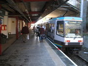
The last 30 years has seen the town developing into an important commuter town for neighbouring Manchester. Large scale housing development has taken place around Unsworth, Redvales, Sunnybank, Brandlesholme, Limefield, Chesham and Elton. The old railway line to Manchester Victoria closed in 1990, and was replaced by the light rapid transit system Metrolink in 1992. The town was also linked to the M66 motorway network, opening in 1978, accessed from the east side of the town.
Governance
In terms of local administration the town was originally a parish, then a select vestry, first with a board of guardians for the poor. Improvement commissioners were added before full borough status was granted. The borough charter was received in 1876 and by 1889 this was raised to that of a county borough.
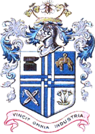
The coat of arms was granted in 1877 and the symbols represent local industry. In the quarters are representations of the anvil, for forging, the golden fleece, for wool, a pair of crossed shuttles, for the cotton industry and a papyrus plant for the paper trade. Above them is a closed visor capped by a mayfly and two red roses. The motto "Vincit Omnia Industria" means "work conquers all".
With the passage of the Local Government Act 1972, Bury merged with the neighbouring municipal boroughs of Radcliffe and Prestwich, together with the urban districts of Whitefield, Tottington and Ramsbottom to become the Metropolitan Borough of Bury in 1974. This borough is part of the metropolitan county of Greater Manchester. On 3 July 2008 there was a referendum in Bury MBC to decide whether the borough should be ruled by a directly elected mayor. The proposal was rejected by the voters.[13]
Geography
 |
Tottington | Ramsbottom | Norden | |
| Ainsworth | Heywood | |||
| Radcliffe | Whitefield | Middleton |
Bury is located in the foothills of the western Pennines in North West England in the northern part of the Greater Manchester Urban Area. The River Irwell flows through the town and this position has proved important in its history and development. Flowing from north to south the river effectively divides the town into two parts on the east and west sides of the valley respectively. The town centre sits close to and above the river on the east side. Bury Bridge is a key bridging point linking the east side of town and the town centre to the western suburbs and Bolton beyond. Other bridges across the river are limited - there is one at Radcliffe Road to the south and at Summerseat to the north. There is also a bridge at the Burrs but this serves a cul-de-sac and does not allow full east–west access. To the south the main tributary, the River Roch, flowing from the east, joins the Irwell close to another significant bridging point, Blackford bridge. This carries the main route south, now the A56, towards Manchester.
The market town was first mentioned as a parish in AD 962. For purposes of the Office for National Statistics, Bury is part of the Greater Manchester Urban Area.
|
|||||
Demography
The town of Bury has a total population of 60,718, whereas the wider Metropolitan Borough has a population of 183,300.[14]
Landmarks
Attractions in Bury include:
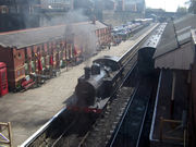
- The East Lancashire Railway, a heritage railway which runs from the town to Heywood, Ramsbottom and Rawtenstall. Based at Bury Bolton Street railway station.
- Bury Museum and Art Gallery, containing the Wrigley collection of paintings including works by Turner, Cox, and De Wint.
- Bury Castle is a fortified manor house built in the mid 13th century by Sir Thomas Pilkington and is now protected as a Scheduled Ancient Monument; the foundations have been excavated and have been open to the public since 2000.[4][5]
- Bury's 'World Famous' Market, which has been on the same site for nearly 600 years; the original licence for a market was granted in 1444. In 2006, out of 1150 markets in the UK, Bury Market was voted the best 'British Market of the Year' by the National Association of British Market Authorities.
- Castlesteads, Greater Manchester is an ancient promontory fort and scheduled monument.
- The regimental museum of the Lancashire Fusiliers.[15]
- Peel Tower, Harcles Hill,[16] above Holcombe village, Ramsbottom. The Peel Tower was built in remembrance of Sir Robert Peel, Prime Minister of the United Kingdom and founder of the police force, who was born in Bury. Hundreds of people climb to the tower each year on Good Friday. Historically this gathering had a principally religious purpose since the hill is said to be strikingly similar to the hill that Jesus is said to have climbed before he was crucified on Good Friday (Calvary).
- Bury Parish Church on the Market Place in the centre of the town is a Grade I listed building.[17][18]
- Silver Street and environs contain many examples of mid-Victorian architecture, using York stone, from the pre-Gothic revival period.
Transport
Bury is connected to other settlements via Bus, Metrolink and Train.
Bury Bolton Street railway station, is home to the East Lancashire Railway, a railway which serves Heywood, Ramsbottom and Rawtenstall. The station is the original railway station of Bury, and was its a mainline station until 1980. Bury Interchange was the replacement for Bolton Street and incorporated a railway station, with services to Manchester Victoria. This was provided by Class 504 units, which were third-rail operated. When the Metrolink took over services of the line, the third rail was lost, and trams replaced trains in 1992.
First Manchester and Easyride Buses operate most bus services around Bury, connecting with destinations within Greater Manchester and Rossendale respectively. The bus station is connected to the Bury Interchange Metrolink station, to provide a vast complex of inter-modal transportation. There is also a free car park at the rear of the complex. The station is located in the centre of Bury, right next to Bury Market, the Millgate Shopping Centre, and the main square.
Manchester Metrolink operates trams to Manchester, Altrincham and Eccles. Part of a £600m development plan on the Metrolink line, is going to open new routes to the following towns Oldham, Rochdale, Droylsden, Chorlton and MediaCityUK in Salford. This Development is planned to open over the following dates: Newton Heath - Central Park in spring 2011, Oldham Mumps in autumn 2011 and Rochdale Railway Station in spring 2012.
There is generally a 6 minute service from Bury to Manchester city centre, with every other tram continuing to Altrincham. Trams to Eccles are provided from Manchester Piccadilly Station. Trams usually run in singular formations, however when the new trams arrive in 2009, trams will be coupled together at peak periods to work in a double formation.
Education
- Colleges
- Bury College, formerly Bury Technical College and Peel Sixth Form College.
- Bury Grammar School has existed since the 1634.[19]
- Holy Cross College, formerly Bury Convent Grammar School. In 2007 it was named 7th in the country.
- High schools located in the area include
- Broad Oak High School
- Bury Church of England High School
- Bury Grammar School (Independent)
- Derby High School
- Elton High School
- St Gabriel's High School
- Tottington High School
Along with that, there is an Islamic madrassa there called Darul Uloom Al-Arabiyyah Al-Islamiyyah.
Sport
Bury has a football club, Bury F.C., which plays at Gigg Lane. The club was formed in 1885 and in 1889 they finished runners up in the inaugural season of the Lancashire League. They were elected to the Football League Second Division in 1894, at the same time as Manchester City. They were promoted to Division One at the end of their first season, beating Liverpool in a play-off.[20] More success came in 1900 when they won the FA Cup followed by a further win in 1903. On the second occasion they beat Derby County 6-0 - a record victory for a Cup Final that still stands. The most recent run of success was in 1996 and 1997 when they won promotion from Football League Division Three and Football League Division Two, being Champions in that Division, in successive seasons.
The club plays in League Two, with a thriving Youth and Centre of Excellence department[21] which has recently produced players such as David Nugent, Simon Whaley and Colin Kazim-Richards. Former legends include free scoring Craig Madden, old timers Norman Bullock and Henry Cockburn, Neville Southall, Dean Kiely, Lee Dixon, Colin Bell, Terry McDermott, Alec Lindsay, Trevor Ross and John McGrath.
Gigg Lane is also used by FC United Of Manchester of the Unibond Northern Premier Division. FC United is a breakaway group of former Manchester United fans adhering to the anti Malcolm Glazer movement and outright commercialism in modern football. F.C. United's attendances are extremely competitive with those of Bury F.C. themselves. Until 2002 Manchester United Reserves were also hosted by Gigg Lane in Bury.
Culture
The Met arts centre, based in the Derby Hall on Market Street, is a small performing arts venue promoting a programme of theatre, music and comedy events. The Met has hosted famous comedy acts such as Steve Coogan and Eddie Izzard in their days before fame.
Bury Art Gallery and Museum on Moss Street is home to a fine collection of Victorian and 20th century art, including works by Turner, Constable, Landseer and Lowry. In 2005 a £1.2 million refurbishment was carried out, designed to provide a brand new museum, art gallery and library all under one roof. This includes a combined Museum & Archives Centre which, based on a radical re-think, uses artefacts, documentation and art to tell the story of the town.[22] The most recent renovation includes modern artefacts such as iPods and electric iRobit hoovers.
The council decided in 2006 to sell Lowry's "The Riverbank" at auction in order to fund part of its Social Services budget shortfall. This has resulted in the government's Museums, Libraries and Archives Council (MLA) removing Bury Council's accredited museum status. The authority will now have limited funding options and will be ineligible for some grants.[23] The Lowry sale raised more than anticipated and some of the money will be used to develop of a new town centre museum for the Lancashire Fusiliers. This will move into the old School of Arts and Crafts on Broad Street opposite the town's museum, art gallery and library, from the existing, inadequate building on Bolton Road.[24]
Bury is also at the heart of the largest public art scheme in the UK -the Irwell Sculpture Trail. Works in Bury include ones by Ulrich Ruckriem, at Radcliffe and Edward Allington, at Ramsbottom with his "Tilted Vase". Ulrich Ruckriem[25] is one of Germany's most eminent artists best known for his monumental stone sculptures. His sculpture in Radcliffe, on the site of the former Outwood Colliery, is one of his largest stone settings to date. Edward Allington's Tilted Vase sits in Market Place in the centre of Ramsbottom and has become a distinctive feature of interest.
The 2008 Mercury Music Prize winning group Elbow, fronted by Guy Garvey, also hail from Bury. Their 2008 classic album "Seldom Seen Kid" won the accolade.
Bury is known for its black puddings[26] so much so, that it is not uncommon to see it as "Bury Black Pudding" on a menu. Bury simnel cake is also a variant of the cake originating in Bury. Bury is also notable for tripe, though there is little demand for this in modern times.
Notable people
- Victoria Wood, BAFTA award winning comedienne. She went to Bury Grammar School.[27]
- John Kay, the inventor of the Flying Shuttle, one of the key inventions of the Industrial Revolution. He was born to a yeoman farming family at Park, a tiny hamlet just North of Bury, on 16 June 1704.[28] A memorial to John Kay stands in the heart of Bury - in Kay Gardens.[12] He also features as one of twelve subjects portrayed in the epic Manchester Murals, by Ford Madox Brown, that decorate the Great Hall, Manchester Town Hall and depict the history of the city. The piece shows John Kay being smuggled to safety as rioters, who feared their jobs were in danger, sought to destroy looms whose invention he had made possible. This was a key moment in the struggle between labour and new technology. He eventually fled to France and died in poverty.
- James Wood, Dean of Ely Cathedral and Master of St John's College, Oxford was born Bury in 1760. A pupil at Bury Grammar School, he won an exhibition to St John's College and was a college tutor from 1789 to 1814. During this time he published the 'Principles of Mathematics and Natural Philosophy'. He was appointed Dean of Ely in 1820. He served as Master of St John's from 1815 and left his library to the college upon his death in 1839.[29]
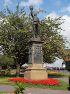
- Sir Robert Peel (1788–1850), the 19th century Prime Minister best known today for the repeal of the Corn Laws and his introduction of the modern police force (hence the terms "Bobbies" and "Peelers"), was born in Bury.[30] He is also notable for forming the famous British Police division, 'Scotland Yard' in London. A monument, Peel Tower, now exists to his memory. As this is situated nearly 1,000 feet above sea level, it is easily recognisable for miles around. The tower itself was not built for Sir Robert, but to provide work for local workers and was later dedicated to him. A statue of Sir Robert Peel stands in Market Place, outside the Robert Peel public house. You will notice that Sir Robert has his waistcoat fastened the wrong way round.
- Professor Sir John Charnley, born, son of a Bury pharmacist, in Bury in 1911. He wrote 'The Closed Treatment of Common Fractures', first published in 1950 which became a standard text for the subject. His subsequent achievement in developing hip replacement surgery, in 1962, is acknowledged as a ground breaking development that changed the approach to orthopaedic surgery. He established a centre for hip surgery at Wrightington Hospital, near Wigan where he worked. He was knighted for his work in 1977.[31] The John Charnley Research Institute, Wrightington Hospital, near Wigan was named in his honour.
- Mark E. Smith, frontman and the only permanent member of post-punk band The Fall grew up in Prestwich in Bury. On the 2010 album Your Future Our Clutter is the track "Bury Pts. 1+3", with lyrics loosely relating to the place.
- Kelly, Barrie, sprinter who competed in the 1968 Summer Olympics in Mexico City, the 1966 and 1970 Commonwealth Games in Jamaica and Edinburgh and two European championships, Budapest in 1966 and Athens in 1969. He was British Champion, indoors and outdoors at 60 m and 100 m several times during this period.
- Parry, Gareth (Gaz), rock climbing. One of Britain's most successful rock climbers. A former British champion in 1996 and 2002. Competed for Great Britain at the highest level for many years. Current British bouldering team coach.
- Smith, Lawrie, yachtsman, arguably Britain's most successful racing sailor. Learnt to sail at Elton Sailing Club, Bury. Won bronze medal at the Barcelona Olympics in 1992, and the Fastnet Race. Skippered British Challenger in the America's Cup and finished fourth in Whitbread Round the World Race in 1989/90.
- Richmal Crompton, author was born on Manchester Road, Bury (a plaque marks the house).[32]
- Helen Flanagan Actress best known for her role as Rosie Webster in Coronation Street
- Suzanne Shaw Originally famous for winning the show Popstars and being a member of Hear'say, Shaw is now the star of West End shows as well as a singer, actress and television presenter.
- Gary Neville, current Manchester United captain, and his younger brother former United player Phil Neville, Everton midfielder and captain.
- Elbow, the band, achieved the Mercury Music Prize in 2009, for their album 'The Seldom Seen Kid'.
- Danny Boyle, Oscar-winning film director of Slumdog Millionaire.
- Andy Goram, Scottish international footballer.
- John Partridge, performer notably for playing the role of Christian in Eastenders
- Lisa Riley, Actress & Television Presenter best known for her role as Mandy Dingle in Emmerdale was born in Bury.
- Antony Cotton, Actor and television host best known for his role as Sean Tully in Coronation Street was born in Bury.
- Matt Littler, Actor best known for his role as Max Cunningham in Hollyoaks was born in Bury and was a former pupil of Elton High School.
- Gemma Atkinson, Actress and lad mags favourite was born in Bury.
- Vicky Binns, Actress best known for her role as Molly Dobbs in Coronation Street was born in Bury.
- Jennie McAlpine, Actress best known for her role as Fiz in Coronation Street was born in Bury.
- Cherie Blair, Successful barrister and former Prime Minister Tony Blair's wife was born in Bury.
- John Spencer, World Snooker Champion was born in Bury.
- Jazz Dhiman, Professional Actor and Artist - Lives in the area.
- Zabel Nick, Professional Actor - Lives in the area.
- Steve Evets,Professional Actor - Looking For Eric, Lives in the area.
Members of Parliament
- Burt, Alistair, Member of Parliament for Bedfordshire North East was born in Bury and was head boy at Bury Grammar School
- Chaytor, David, Member of Parliament for Bury North was born in Bury. Educated at Bury Grammar School.[33]
- Crausby, David, Member of Parliament for Bolton North East was born in Bury. Educated at the Derby High School
Twin towns
 Angoulême, a town and commune in South Western France
- Tulle, a small town in the Corrèze Department. Originally twinned with Prestwich.
 Schorndorf, a medieval market town to the east of Stuttgart, capital of Baden-Wurttemberg, Germany.
 Woodbury, New Jersey, United States.
 Datong, China.
References
- ↑ Greater Manchester Gazetteer, Greater Manchester County Record Office, Places names - B, http://www.gmcro.co.uk/Guides/Gazeteer/gazzb.htm, retrieved 17 October 2008
- ↑ A brief history of Bury, Bury Metropolitan Borough Council, ISBN 0950247200, http://www.bury.gov.uk/VisitorGuidesAndMaps/History.htm, retrieved 1 August 2009
- ↑ 3.0 3.1 Dobb, Arthur J (1970), 1846 Before and After - A Historical Guide to the Ancient Parish of Bury, Bircle Parish Church Council
- ↑ 4.0 4.1 Bury Castle, Bury Educational Schools Net, http://atschool.eduweb.co.uk/tcsc/millennium2/Castle/Bury_Castle.htm, retrieved 2008-01-04
- ↑ 5.0 5.1 Bury Castle, Pastscape.org.uk, http://www.pastscape.org.uk/hob.aspx?hob_id=45189, retrieved 2008-01-04
- ↑ http://www.spinningtheweb.org.uk/m_display.php?irn=50&sub=nwcotton&theme=places&crumb=Bury Spinning the Web
- ↑ McNeil, Robina; Nevell M. (2000), A guide to the industrial archaeology of Greater Manchester, Association for Industrial Archaeology, ISBN 978-0-9528930-3-5
- ↑ Bannister, Jean (1974), From Parish to Metro - Two Centuries of Local Government in a Lancashire Town, Bury Times, ISBN 978-0-9504263-0-3
- ↑ Smellie, Kingsley Bryce (1946), A history of local government, G. Allen & Unwin ltd, ISBN 0043520162
- ↑ Health of Towns Commission, 1844
- ↑ Moorhouse, Geoffrey (1992), Hell's Foundations - A Town, Its Myths and Gallipoli, Hodder & Stoughton, ISBN 978-0-340-43044-6
- ↑ 12.0 12.1 Wyke, Terry; Cocks, Harry (2004), Public Sculpture of Greater Manchester, Liverpool University Press, ISBN 978-0-85323-567-5
- ↑ Bury elected mayor plan rejected, BBC News, 4 July 2008, http://news.bbc.co.uk/1/hi/england/manchester/7489025.stm, retrieved 1 August 2009
- ↑ Bury Mid Year Population Estimates 2007, Bury Metropolitan Borough Council, http://www.bury.gov.uk/NR/rdonlyres/F6028C08-34DD-4A41-BF20-651882718F79/0/PopMYE2007factsheet.pdf, retrieved 22 March 2010
- ↑ Fusilier's Museum, Lancashire
- ↑ Ordnance Survey Map showing Harcles Hill and Bull Hill on Holcombe Moor to the north-east
- ↑ Parish Church of St Mary, Bury, Images of England, http://www.imagesofengland.org.uk/Details/Default.aspx?id=210680, retrieved 1 August 2009
- ↑ Listed Buildings in Bury MBC, Bury Metropolitan Borough Council, November 2004, http://www.bury.gov.uk/NR/rdonlyres/4B91B45C-4C94-4B8D-962F-E57B02203A05/0/ListedBuildingsAZ.pdf, retrieved 1 August 2009
- ↑ History, Character and Values, Bury Grammar School, http://www.burygrammarschoolboys.co.uk/page-261.html, retrieved 1 August 2009
- ↑ Cullen, Peter (1999), Bury F.C., 1885–1999: The Official History, Yore Publications, ISBN 978-1-874427-28-5
- ↑ Bury F.C. Youth and Centre of Excellence Official Web Site
- ↑ Honeyford, Kate (13 May 2005), Bury Museum Open Again After Re-fit for the 21st Century, 24 Hour Museum, http://www.culture24.org.uk/sector+info/art28187, retrieved 1 August 2009
- ↑ Lowry sale council loses status, BBC News, 15 December 2006, http://news.bbc.co.uk/1/hi/england/manchester/6183547.stm, retrieved 1 August 2009
- ↑ Lancashire Fusiliers, Museum Appeal
- ↑ Ulrich Ruckriem
- ↑ Bentley, James (2 February 2006), Bury Market: best in UK, BBC, http://www.bbc.co.uk/manchester/content/articles/2006/02/02/020206_bury_market_award_feature.shtml, retrieved 1 August 2009
- ↑ "WOOD, Victoria", Who's who 2009, Oxford University Press, 2008, http://www.ukwhoswho.com/view/article/oupww/whoswho/U40576, retrieved 1 August 2009
- ↑ Farnie, D. A. (2004), "Kay, John (1704–1780/81)", Oxford Dictionary of National Biography, Oxford University Press, http://www.oxforddnb.com/view/article/15194, retrieved 1 August 2009
- ↑ Sutton, C. W. (2004), "Wood, James (1760–1839)", Oxford Dictionary of National Biography, Oxford University Press, http://www.oxforddnb.com/view/article/29873, retrieved 1 August 2009
- ↑ Prest, John (2004), "Peel, Sir Robert, second baronet (1788–1850)", Oxford Dictionary of National Biography, Oxford University Press, http://www.oxforddnb.com/view/article/21763, retrieved 1 August 2009
- ↑ Duthie, R. B. (2004), "Charnley, Sir John (1911–1982)", Oxford Dictionary of National Biography, Oxford University Press, http://www.oxforddnb.com/view/article/30920, retrieved 1 August 2009
- ↑ Cadogan, Mary (2004), "Lamburn, Richmal Crompton", Oxford Dictionary of National Biography, Oxford University Press, http://www.oxforddnb.com/view/article/34386, retrieved 1 August 2009
- ↑ About David, David Chaytor, http://iwc2.labouronline.org/165560/about_david, retrieved 1 August 2009
External links
|
||||||||||||||||||||