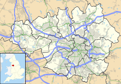
Stockport
| Stockport | |
.jpg) Stockport Town Hall |
|
 Stockport
|
|
| Population | 136,082 (2001 Census) |
|---|---|
| OS grid reference | |
| - London | 157 mi (253 km) SE |
| Metropolitan borough | Stockport |
| Metropolitan county | Greater Manchester |
| Region | North West |
| Country | England |
| Sovereign state | United Kingdom |
| Post town | STOCKPORT |
| Postcode district | SK1-SK8, SK12 |
| Dialling code | 0161 |
| Police | Greater Manchester |
| Fire | Greater Manchester |
| Ambulance | North West |
| EU Parliament | North West England |
| UK Parliament | Stockport |
| List of places: UK • England • Greater Manchester | |
Stockport is a large town in Greater Manchester, England. It lies on elevated ground on the River Mersey at the confluence of the rivers Goyt and Tame, 6.1 miles (9.8 km) southeast of the city of Manchester. Stockport is the largest settlement of the Metropolitan Borough of Stockport, and has a population of 136,082, the wider borough having 281,000.
Historically a part of Cheshire, Stockport in the 16th century was a small town entirely on the southbank of the Mersey, and known for the cultivation of hemp and rope manufacture and in the 18th century the town had one of the first mechanised silk factories in the United Kingdom. However, Stockport's predominant industries of the 19th century were the cotton and allied industries. Stockport was also at the centre of the country's hatting industry which by 1884 was exporting more than six million hats a year. In December 1997 the last Stockport hat works closed. The town's hatting heritage is preserved at 'Hat Works – the Museum of Hatting'.
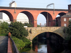
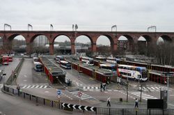
Dominating the western approaches to the town is the Stockport Viaduct. Built in 1840, the viaduct's 27 brick arches over the River Mersey carry the mainline railways from Manchester to Birmingham and London. This structure featured as the background in many paintings by L.S. Lowry. Lowry often visited the Stockport War Memorial Gallery on Greek Street especially during the annual Stockport Art Guild exhibition of paintings and sculpture.
Contents |
History

Toponymy
Stockport was first recorded as "Stokeport" in 1170.[1][2] The currently accepted etymology is Old English stoc, a market place, with port, a hamlet (but more accurately a minor settlement within an estate); hence, a market place at a hamlet.[1][2] Older derivations include stock, a stockaded place or castle, with port, a wood, hence a castle in a wood.[3] The castle part of the name probably refers to Stockport Castle, a 12th century motte-and-bailey first mentioned in 1173.[4]
Other derivations have been formed, based on early variants of the name such as Stopford and Stockford. There is evidence that a ford across the Mersey existed at the foot of the town centre street now known as Bridge Street Brow. Stopford retains a use in the adjectival form, Stopfordian, used for Stockport-related items, and pupils at Stockport Grammar School style themselves Stopfordians.[5] By contrast, former pupils of nearby Stockport School are known as Old Stoconians. Stopfordian is the general term used for people from Stockport, much as someone from London would be a Londoner.
Stockport has never been a sea or river port. The Mersey is not navigable to anything much above canoe size; in the centre of Stockport it has been culverted and the main shopping street, Merseyway, built above it.
Early history
The earliest evidence for human occupation in the wider area are microliths from the hunter-gatherers of the Mesolithic period (the Middle Stone Age, about 8000–3500 BC) and weapons and tools from the Neolithic period (the New Stone age, 3500–2000 BC). Early Bronze Age (2000–1200 BC) remains include stone hammers, flint knives, palstaves (i.e. bronze) and funery urns; all finds have been chance discoveries, rather than a systematic search of a known site. There is a gap in the age of finds between about 1200 BC and the Roman period (i.e. after about 70 AD). This may indicate depopulation, possibly due to a poorer climate.[6]
There is little evidence of a Roman military station at Stockport, despite a strong local tradition.[7][8] It is assumed that roads from Cheadle to Ardotalia (Melandra) and Manchester to Buxton crossed close to the town centre. The preferred site is at a ford over the Mersey, known to be paved in the eighteenth century, but it has never been shown that this or any of the roads in the area are Roman. Hegginbotham reported (in 1892) the discovery of Roman mosaics at Castle Hill (the area around Stockport market) in the late eighteenth century, during the construction of a mill, but noted it was 'founded on tradition only'; substantial stonework found in the area has never been dated by modern methods. However, Roman coins and pottery were probably found there during the eighteenth century. A cache of coins dating 375–378 may have come from the banks of the Mersey at Daw Bank; these were possibly buried for safekeeping at the side of a road.[7]
Six coins from the reigns of the Anglo-Saxon English Kings Edmund (reigned 939–946) and Eadred (reigned 946–955) were found during ploughing at Reddish Green in 1789.[1][9] There is contrasting source material about the significance of this; Arrowsmith takes this as evidence for existence of a settlement at that time, but Morris states the find could be "an isolated incident". This small cache is the only Anglo-Saxon find in the area.[1] However, the etymology Stoc-port suggests inhabitation.[10]
Medieval period
No part of Stockport appears in the Domesday Book of 1086. The area north of the Mersey was part of the hundred of Salford, which was poorly surveyed. The area south of the Mersey was part of the Hamestan (Macclesfield) hundred. (Cheadle, Bramhall, Bredbury, and Romiley are mentioned, but these all lay just outside the town limits.) The survey includes valuations of the Salford hundred as a whole and Cheadle (etc.) for the times of Edward the Confessor (i.e. just before the Norman invasion of 1066) and the time of the survey. The reduction in value is taken as evidence of destruction by William the Conqueror's men in the campaigns generally known as the Harrying of the North. The omission of Stockport was once taken as evidence that destruction was so complete that a survey was not needeed (see e.g. Husain[11]).
Arrowsmith argues from the etymology that Stockport may have still been a market place associated with a larger estate, and so would not be surveyed separately. The Anglo-Saxon landholders in the area were dispossessed and the land divided amongst the new Norman rulers. The first borough charter was granted in about 1220 and was the only basis for local government for six hundred years.
A castle held by Geoffrey de Costentin is recorded as a rebel stronghold against Henry II in 1172–3. There is an incorrect local tradition that Geoffrey was the king's son, Geoffrey II, Duke of Brittany, who was one of the rebels.[12] Dent gives the size of the castle as about 31 by 60 m (102 by 200 ft), and suggests it was similar in pattern to those at Pontefract and Launceston. The castle was probably ruinous by the middle of the sixteenth century, and in 1642 it was agreed to demolish it. Castle Hill, possibly the motte, was levelled in 1775 to make space for Warren's mill, see below.[13][14] Nearby walls, once thought to be either part of the castle or of the town walls, are now thought to be revetments to protect the cliff face from erosion.[15]
Industrialisation
"At this place poverty is not much felt except by those who are idle, for all persons capable of tying knots may find work in the silk mills … children of six years earn a shilling a week and more as they grow capable of deserving it."
Stockport was one of the prototype textile towns.[17] In the early eighteenth century, England was not capable of producing silk of sufficient quality to be used as the warp in woven fabrics. Suitable thread had to be imported from Italy, where it was spun on water-powered machinery. In about 1717 John Lombe travelled to Italy and copied the design of the machinery. On his return he obtained a patent on the design, and went into production in Derby. When Lombe tried to renew his patent in 1732, silk spinners from towns including Manchester,Macclesfield, Leek, and Stockport successfully petitioned parliament to not renew the patent. Lombe was paid off, and in 1732 Stockport's first silk mill (indeed, the first water-powered textile mill in the north-west of England) was opened on a bend in the Mersey. Further mills were opened on local brooks.
Silk weaving expanded until in 1769 two thousand people were employed in the industry. By 1772 the boom had turned to bust, possibly due to cheaper foreign imports; by the late 1770s trade had recovered.[16] The cycle of boom and bust would continue throughout the textile era.
The combination of a good water power site (described by Rodgers as "by far the finest of any site within the lowland" [of the Manchester region][17]) and a workforce used to textile factory work meant Stockport was well-placed to take advantage of the phenomenal expansion in cotton processing in the late eighteenth century. Warren's mill in the market place was the first. Power came from an undershot water wheel in a deep pit, fed by a tunnel from the River Goyt. The positioning on high ground, unusual for a water powered mill, contributed to an early demise, but the concept of moving water around in tunnels proved successful, and several tunnels were driven under the town from the Goyt to power mills.[18] In 1796, James Harrisson drove a wide cut from the Tame which fed several mills in the Park, Portwood.[19] Other water-powered mills were built on the Mersey.
Hatmaking was established in north Cheshire and south-east Lancashire by the 16th century. In the early 1800s the number of hatters in the area began to increase, and a reputation for quality work was created. The London firm of Miller Christy bought out a local firm in 1826, a move described by Arrowsmith as 'a watershed'. By the latter part of the century hatting had changed from a manual to a mechanised process, and was one of Stockport's primary employers; the area, with nearby Denton, was the leading national centre. Support industries, such as blockmaking, trimmings, and leatherware, became established.
The First World War cut off overseas markets, which established local industries and eroded Stockports eminence. Even so, in 1932 over 3000 people worked in the industry, making it the third biggest employer, after textiles and engineering. The depression of the 1930s and changes in fashion greatly reduced the demand for hats, and the demand that existed was met by cheaper wool products made elsewhere, for example the Luton area. By 1966–7 all the major companies merged to form Associated British Hat Manufacturers, leaving Christy's and Wilson's (at Denton) as the last two factories in production. First Wilson's, and then (in 1997) Christy's closed, bringing to an end over 400 years of hatting in the area.[20][21][22] The industry is commemorated the UK's only dedicated hatting museum, Hat Works.[23][24]
From the 17th century Stockport became a centre for the hatting industry and later the silk industry. Stockport expanded rapidly during the Industrial Revolution, helped particularly by the growth of the cotton manufacturing industries. However, economic growth took its toll, and 19th century philosopher Friedrich Engels wrote in 1844 that Stockport was "renowned as one of the duskiest, smokiest holes in the whole of the industrial area".[25] The town was connected to the national canal network by the 5 miles (8.0 km) of the Stockport branch of the Ashton Canal opened in 1797 which continued in use until the 1930s. Much of it is now filled in, but there is an active campaign to re-open it for leisure uses.
Recent history
Since the start of the 20th century Stockport has moved away from being a town dependent on cotton and its allied industries to one with a varied base. It makes the most of its varied heritage attractions, including a national museum of hatting, a unique system of underground Second World War air raid tunnel shelters in the town centre, and a late medieval merchants' house on the 700-year-old Market Place. In 1967, the Stockport air disaster occurred, when a British Midland Airways C-4 Argonaut aeroplane crashed in the Hopes Carr area of the town, resulting in 72 deaths among the passengers and crew.
In recent years, Stockport Metropolitan Borough Council has embarked on an ambitious regeneration scheme, known as Future Stockport. The plan is to bring over 3,000 residents into the centre of the town, and revitalise its residential property and retail markets, in a similar fashion to the nearby city of Manchester. Many ex-industrial areas around the town's core will be brought back into productive use as mixed-use residential and commercial developments.
Governance
Civic history
The Municipal Corporations Act 1835 made Stockport a municipal borough divided into six wards with a council consisting of 14 Aldermen and 42 Councillors. In 1888, its status was raised to County Borough, becoming the County Borough of Stockport. Since 1972, Stockport has been twinned with in Béziers in France.[26] In 1974, under the Local Government Act 1972 Stockport amalgamated with neighbouring districts to form the Metropolitan Borough of Stockport in the metropolitan county of Greater Manchester.
In 1986, Greater Manchester County Council was abolished and Stockport Metropolitan Borough Council assumed many of its functions, effectively becoming a unitary authority.
Parliamentary representation
There are four parliamentary constituencies in the Stockport Metropolitan Borough: Stockport, Cheadle, Hazel Grove, and Denton and Reddish. Stockport has been represented by Labour MP Ann Coffey since 1992; Mark Hunter has been the Liberal Democrat MP for Cheadle since a 2005 by-election; and Andrew Stunell has been the Liberal Democrat MP for Hazel Grove since 1997. The constituency of Denton and Reddish bridges Stockport and Tameside; the current member is Andrew Gwynne.
Geography
| Stockport | ||||||||||||||||||||||||||||||||||||||||||||||||||||||||||||
|---|---|---|---|---|---|---|---|---|---|---|---|---|---|---|---|---|---|---|---|---|---|---|---|---|---|---|---|---|---|---|---|---|---|---|---|---|---|---|---|---|---|---|---|---|---|---|---|---|---|---|---|---|---|---|---|---|---|---|---|---|
| Climate chart () | ||||||||||||||||||||||||||||||||||||||||||||||||||||||||||||
|
||||||||||||||||||||||||||||||||||||||||||||||||||||||||||||
|
||||||||||||||||||||||||||||||||||||||||||||||||||||||||||||
At (53.408°, -2.149°), and 157 miles (253 km) northwest of London, Stockport stands on elevated ground, 6.1 miles (9.8 km) southeast of Manchester city centre, at the confluence of the rivers Goyt and Tame. In terms of area, Stockport is the largest metropolitan town in Europe. It shares a common boundary with the City of Manchester.
Divisions and suburbs
|
|||||
Demography
| Stockport Compared | |||
|---|---|---|---|
| 2001 UK census | Stockport[27] | Stockport MB[28] | England |
| Total population | 136,082 | 284,528 | 49,138,831 |
| White | 95.5% | 95.7% | 91% |
| Asian | 2.0% | 2.1% | 4.6% |
| Black | 0.5% | 0.4% | 2.3% |
| Christian | 74.9% | 75.4% | 72% |
| Muslim | 1.8% | 1.8% | 3.1% |
| No religion | 15.3% | 14.2% | 15% |
As of the 2001 UK census, Stockport had a population of 136,082. The 2001 population density was 11,937 per mi² (4,613 per km²), with a 100 to 94.0 female-to-male ratio.[29] Of those over 16 years old, 32% were single (never married) and 50.2% married.[30] Stockport's 58,687 households included 33.1% one-person, 33.7% married couples living together, 9.7% were co-habiting couples, and 10.4% single parents with their children, these figures were similar to those of Stockport Metropolitan Borough and England.[31] Of those aged 16–74, 29.2% had no academic qualifications, significantly higher than that of 25.7% in all of Stockport Metropolitan Borough but significantly similar to 28.9% in all of England.[28][32]
Although suburbs such as Woodford, Bramhall and Hazel Grove rank amongst the wealthiest areas of the United Kingdom and 45% of the borough is green space, districts such as Adswood and Brinnington suffer from widespread poverty and post-industrial decay. In the north-west of the borough are the relatively prosperous areas of Heaton Moor and Heaton Mersey, which together with Heaton Chapel and Heaton Norris comprise the so-called Four Heatons.
Population change
| Population growth in Stockport since 1901 | |||||||||||
|---|---|---|---|---|---|---|---|---|---|---|---|
| Year | 1901 | 1911 | 1921 | 1931 | 1939 | 1951 | 1961 | 1971 | 1981 | 1991 | 2001 |
| Population | 92,832 | 108,682 | 123,309 | 125,490 | 134,132 | 141,650 | 142,543 | 139,598 | 136,792 | 132,813 | 136,082 |
| County Borough 1901–1971 [33] • Urban Subdivision 1981–2001[34][35][36] | |||||||||||
Economy
Stockport's principal commercial district is located in the town centre, with branches of most high-street stores to be found in the Merseyway Shopping Centre or The Peel Centre. Grand Central Leisure boasts an Olympic sized swimming pool, a ten-screen cinema, bars, a bowling alley, health complex, and several restaurants. Stockport is located six miles (10 km) from Manchester, making it convenient for commuters and shoppers. In 2008, the council's £500M plans to redevelop the town centre were cancelled. The construction company, Lend Lease Corporation, pulled out of the project, blaming the credit crunch for their choice.[37]
Landmarks
Stockport is home to the following:
- Stockport boasts the UK's only hat museum, the "Hat Works" based in Wellington Mill - a thriving hat factory in Victorian times.[38]
- Stockport Town Hall, with its ballroom, described by Poet Laureate, John Betjeman as 'magnificent' containing the largest Wurlitzer theatre organ in Britain designed by Sir Alfred Brumwell Thomas.
- Stockport Air Raid Shelters is a museum based around the underground tunnels dug during World War II to protect local inhabitants during air raids
- Vernon Park is the main municipal park, located a short distance to the east towards Bredbury. It was opened on September 20, 1858 on the anniversary of the Battle of Alma in the Crimean War. Named after Lord Vernon who presented the land for the park to the town.
- St Elisabeth's Church, Reddish, and model village. Mill community designed in the main by Alfred Waterhouse for the workers from Houldsworth Mill, at the time the largest cotton mill in the world.
- St Mary's Church on the Market Place is the town's oldest place of worship with parts dating to the early 14th century and houses the Stockport Heritage centre run by local volunteers on market days. The church is Grade I listed.[39]
- Stockport Plaza is a Grade II* listed Super Cinema and Variety Theatre built in 1932.[40] It is the last remaining venue of its kind still operating in its original format making it of international significance.
Stockport Viaduct
Stockport Viaduct is one of the Western Europe's biggest brick structures. It is 111 feet (34 m) high, and carries a four-tracks over the River Mersey on the line to Manchester. The viaduct represents a major feat of Victorian engineering, it was built in 21 months at a cost of £70,000 and consists of 11,000,000 bricks.[41] The structure is Grade II* listed.[42]
War Memorial & Art Gallery
Located on Greek Street, diagonally opposite the Town Hall.
The Pyramid
Beside the M60 (Manchester orbital motorway) at junction 1 is the Stockport Pyramid, a distinctive glass and steel building. It was designed by the architect Maxwell Hutchinson. The building is steel framed with mostly blue glass paneling and some clear glass paneling at the apex. It was intended to be the signature building for a much larger 'kings valley' commercial development designed in 1987. Construction began in the early 1990s with completion in 1992. However, with another economic downturn the project went no further as the developers went into administration., and the building lay empty for several years. In 1995 the Co-operative Bank (who funded the developers) repossessed The Pyramid and opened it as a Call centre for the bank themselves, which it remains to this day.
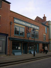
Staircase House
Staircase House is a Grade II* listed medieval townhouse in the Market Place.[43] The building has been modified several times, but is probably the oldest secular building in Stockport.[15] Staircase House is the home to the Stockport Story Museum. The museum claims to detail over 10,000 years of Stockport's history.[44]
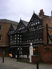
Underbank Hall
Located in the centre of Stockport, Underbank Hall is a Grade II* listed late 16th century timber framed building. It was built as the townhouse of the Arderne family from nearby Bredbury. The family occupied the building until 1823.[45] Since 1824, it has been used as a bank. The current main banking hall lies behind the 16th century part and dates from 1915.[15]
Transport
The Manchester orbital M60 motorway and A6 road to London cross at Stockport. Stockport railway station is a mainline station on the Manchester spur of the West Coast Main Line. Stockport is connected with Central London by Virgin trains with services departing every twenty minutes. Stockport Tiviot Dale station also served the town centre between 1865 and 1967, lying on routes from Liverpool, Derby and Sheffield. The station site now lies under the M60 motorway.[46]
Manchester Airport (Ringway), the busiest in the UK outside London, is located five miles (8 km) southwest of the town. Stockport is also home to Stockport bus station, which serves as a terminus for many services across the borough.
Education
Stockport College has sites in the town centre and Heaton Moor. Also Stockport is home to Stockport Grammar School established in 1487, the oldest in the North of England
Sports
- Football
Stockport is home to two professional sports teams, both of which play at Edgeley Park stadium. Stockport County F.C. currently play in Football League Two (fourth tier). They were formed in 1883 as Heaton Norris Rovers, changing their name to Stockport County in 1890 to reflect the town of Stockport's new status as a County borough. They joined the Football League in 1900 and have been members ever since. Perhaps their most successful season ever was the 1996-97 season, where they reached the Football League Cup semi-finals and won promotion from Division Two (third tier) into what is currently known as The Championship. Notable former players include Brett Angell, George Best, Kevin Francis, Jim Gannon, Wayne Hennessey, Paul Jones, Chris Marsden, Andy Mutch, Micky Quinn and Len White, Notable former managers include Danny Bergara, Dave Jones, Gary Megson, and Jim Gannon. In the late 1990s, former Stockport County chairman Brendan Elwood expressed an interest in departing from Edgeley Park to Maine Road in Moss Side, but this did not happen. The Maine Road stadium which opened in 1923, was the home of Manchester City until 2003. Following a recent take - over, County are looking to either re - develop Edgeley PArk, or move to a new stadium in Stockport.
- Rugby Union
Sale Sharks Rugby Union Club, also play at Edgeley Park. They won the Guinness Premiership title in 2006 and boast current England internationals Mark Cueto, Charlie Hodgson and Andrew Sheridan.
- Swimming
Stockport Metro Swimming Club, based at Grand Central Pools, is the most successful British swimming club, through the last three Olympic Games. Stockport Metro swimmers have claimed 50% of British swimming's medal haul. At the 1996 Summer Olympics in Atlanta, Graeme Smith won bronze in the 1500m freestyle,[47] and, at the 2004 Summer Olympics in Athens, Steve Parry won bronze in the 200m butterfly.[48] Most recently, at the 2008 Summer Olympics in Beijing, Keri-Anne Payne and Cassie Patten won silver and bronze, respectively, in the 10 km open water swim.[49]
- Lacrosse
Stockport is the heart of English lacrosse, a sport introduced to the UK by a Canadian touring side during the reign of Queen Victoria. Stockport Lacrosse Club, HQ at Stockport Cricket Club, Cale Green, was founded in 1876, with the first match being played as Shaw Heath Villas. It is claimed that Stockport is the oldest club in the world and currently has a number of men's, ladies', and junior teams. There are also lacrosse clubs at Norbury (Hazel Grove) Cheadle, Cheadle Hulme, Heaton Mersey, Heaton Mersey Guild, and Mellor. The Stockport Grammar School old boys (Old Stopfordians) play at Disley, with other clubs in the area at Poynton, Ashton, Oldham, Timperley, Sale, Didsbury and Wilmslow. Edgeley Park hosted the 1978 Lacrosse World Cup.
- Athletics
Stockport has three athletics clubs — Manchester Harriers & AC, Stockport Harriers & AC, and DASH Athletics Club. Manchester Harriers train at William Scholes' Playing Fields in Gatley, and they organise highly-regarded schools cross country races throughout the winter. Stockport Harriers are based at Woodbank Park in Offerton, and have several International middle-distance and endurance athletes including Steve Vernon. DASH Athletics Club are the newest Club in Stockport based at both Hazel Grove Recreation Centre,and the Manchester Regional Arena at Sportcity in Manchester. In 2006 DASH AC Coach Geoff Barratt was UK Athletics' Development Coach of the Year, and in 2007 the club won England Athletics North West Junior Club and North West Overall Club of The Year accolades.
- Tennis
Stockport is the birthplace of the late tennis player, Fred Perry. Perry is the last Briton to win both the Men's Singles titles at Wimbledon and the US Open (both in 1936), making him the last British male to win a Grand Slam title.
Youth organisations
The Stockport area is covered by several different squadrons of the Air Training Corps. Two of these Squadrons are 162 (Stockport) Squadron based on the A6 1804 Squadron ATC based on Reddish Road. There is also a vast amount of youth basketball teams, and currently the Stockport Senior mens league team are in D3 of the EBL league after their promotion earlier last season from Division 4.
Twin towns — sister cities
Stockport is twinned with:
See also
- List of people from Stockport
- Alan Lowndes
References
- ↑ 1.0 1.1 1.2 1.3 Arrowsmith 1997, p. 23
- ↑ 2.0 2.1 Mills, A D (1997), Dictionary of English Place-Names (2nd ed), Oxford: Oxford University Press, ISBN 0-19-280074-4
- ↑ "Local History", Stockport MBC web pages, http://www.stockport.gov.uk/content/communitypeopleliving/historyandheritage/localhistory/?a=5441, retrieved 2007-04-02
- ↑ Stockport Castle, Pastscape.org.uk, http://www.pastscape.org.uk/hob.aspx?hob_id=1085399, retrieved 2008-01-05
- ↑ "Old Stopfordians' Association", Stockport Grammar School - an independent school near Manchester, England, http://www.stockportgrammar.co.uk/index.php?menuitem_id=219, retrieved 2007-04-03
- ↑ Arrowsmith 1997, pp. 9–14
- ↑ 7.0 7.1 Arrowsmith 1997, pp. 18–19
- ↑ Dent 1977, p. 1
- ↑ Morris, Mike, ed., Medieval Manchester; A Regional Study. The Archaeology of Greater Manchester volume 1, Manchester: Greater Manchester Archaeological Unit, pp. 13–15, ISBN 0-946126-02-X, " ... foolhardy to attempt any historical interpretation of the pre-tenth century evidence. (it) could represent an isolated incident."
- ↑ Dent 1977, pp. 1–2
- ↑ Husain 1973, p. 12
- ↑ See Dent (1977) for the traditional view; and Arrowmith (1997), p. 31 for the refutation.
- ↑ Dent 1977, p. 2
- ↑ Pevsner & Edward Hubbard 1971, p. 338
- ↑ 15.0 15.1 15.2 Arrowsmith 1996, p. ?
- ↑ 16.0 16.1 Arrowsmith 1997, pp. 97–101
- ↑ 17.0 17.1 Rodgers 1962, p. 13
- ↑ Dranfield, Coral (2006), Rivers under your feet: the story of Stockport's water tunnels, Kevin Dranfield, ISBN 0-9553995-0-5
- ↑ Arrowsmith 1997, p. 130; Ashmore (1975).
- ↑ McKnight, Penny (2000), Stockport hatting, Stockport: Stockport M.B.C., Community Services Division, pp. 1–9, ISBN 0-905164-84-9
- ↑ Arrowsmith 1997, pp. 156–7
- ↑ Arrowsmith 1997, pp. 225–6
- ↑ Hat Works - about us, Hat Works, http://www.hatworks.org.uk/about_us.asp, retrieved 2008-10-02
- ↑ Williamson, Hannah (2006), "The Character of Hat Works", Manchester Region History Review 17 (2): 111–121
- ↑ Engels, Frederick (1969) [1845], "The great Towns", The Condition of the Working Class in England, Panther, http://www.marxists.org/archive/marx/works/1845/condition-working-class/ch04.htm, "Stockport is renowned throughout the entire district as one of the duskiest, smokiest holes, and looks, indeed, especially when viewed from the viaduct, excessively repellent."
- ↑ Twin towns, Stockport.gov.uk, http://www.stockport.gov.uk/content/communitypeopleliving/towntwinning/twintowns/, retrieved 2008-05-19
- ↑ KS06 Ethnic group: Census 2001, Key Statistics for urban areas, Statistics.gov.uk, 25 January 2005, http://www.statistics.gov.uk/statbase/ssdataset.asp?vlnk=8283&More=Y Retrieved on 5 August 2008.
- ↑ 28.0 28.1 Stockport Metropolitan Borough key statistics, Statistics.gov.uk, http://neighbourhood.statistics.gov.uk/dissemination/LeadKeyFigures.do?a=3&b=276782&c=Stockport&d=13&e=16&g=354915&i=1001x1003x1004&o=1&m=0&r=1&s=1198230591093&enc=1, retrieved 2009-11-01 Retrieved on 17 August 2008.
• Stockport Metropolitan Borough ethnic group data, Statistics.gov.uk, http://neighbourhood.statistics.gov.uk/dissemination/LeadTableView.do?a=3&b=276782&c=Stockport&d=13&e=16&g=354915&i=1001x1003x1004&o=1&m=0&r=1&s=1198230591109&enc=1&dsFamilyId=87, retrieved 2009-11-01 Retrieved on 17 August 2008. - ↑ KS01 Usual resident population: Census 2001, Key Statistics for urban areas, Statistics.gov.uk, 7 February 2005, http://www.statistics.gov.uk/statbase/ssdataset.asp?vlnk=8271&More=Y Retrieved on 17 August 2008.
- ↑ KS04 Marital status: Census 2001, Key Statistics for urban areas, Statistics.gov.uk, 2 February 2005, http://www.statistics.gov.uk/statbase/ssdataset.asp?vlnk=8276&More=Y Retrieved on 5 August 2008.
- ↑ KS20 Household composition: Census 2001, Key Statistics for urban areas, Statistics.gov.uk, 2 February 2005, http://www.statistics.gov.uk/statbase/ssdataset.asp?vlnk=8349&More=Y Retrieved on 5 August 2008.
• Stockport Metropolitan Borough household data, Statistics.gov.uk, http://neighbourhood.statistics.gov.uk/dissemination/LeadTableView.do?a=3&b=276782&c=Stockport&d=13&e=16&g=354915&i=1001x1003x1004&o=1&m=0&r=1&s=1198230591125&enc=1&dsFamilyId=165, retrieved 2009-11-01 Retrieved on 17 August 2008. - ↑ KS13 Qualifications and students: Census 2001, Key Statistics for urban areas, Statistics.gov.uk, 2 February 2005, http://www.statistics.gov.uk/statbase/ssdataset.asp?vlnk=8326&More=Y Retrieved on 5 August 2008.
- ↑ Stockport County Borough, Vision of Britain, http://www.visionofbritain.org.uk/data_cube_table_page.jsp?data_theme=T_POP&data_cube=N_TPop&u_id=10109620&c_id=10001043&add=N Retrieved on 24 July 2008.
- ↑ 1981 Key Statistics for Urban Areas GB Table 1, Office for National Statistics, 1981
- ↑ 1991 Key Statistics for Urban Areas, Office for National Statistics, 1991
- ↑ KS01 Usual resident population: Census 2001, Key Statistics for urban areas, National Statistics, http://www.statistics.gov.uk/StatBase/ssdataset.asp?vlnk=8271&Pos=2&ColRank=1&Rank=224, retrieved 2009-11-01 Retrieved on 24 July 2008.
- ↑ "Town centre future on scrap heap", Stockport Express, 13 August 2008, http://www.stockportexpress.co.uk/news/s/1062298_town_centre_future_on_scrap_heap Retrieved on 17 August 2008.
- ↑ Hat Works Web Site
- ↑ Parish Church of St Mary, Heritage Gateway, http://www.heritagegateway.org.uk/Gateway/Results_Single.aspx?uid=210795&resourceID=5, retrieved 2009-10-31
- ↑ Plaza Cinema, Heritage Gateway, http://www.heritagegateway.org.uk/Gateway/Results_Single.aspx?uid=463552&resourceID=5, retrieved 2009-10-31
- ↑ Stockport Railway Viaduct, Pastscape.org.uk, http://www.pastscape.org.uk/hob.aspx?hob_id=76880, retrieved 2009-11-01
- ↑ Railway Viaduct, Stockport, Heritage Gateway, http://www.heritagegateway.org.uk/Gateway/Results_Single.aspx?uid=%20210778&resourceID=5, retrieved 2009-11-01
- ↑ Staircase Cafe, Heritage Gateway, http://www.heritagegateway.org.uk/Gateway/Results_Single.aspx?uid=210845&resourceID=5, retrieved 2009-10-31
- ↑ About the Museum, Stockport Story Museum, http://www.stockportstory.org.uk/StockportStory_info.asp, retrieved 2009-11-01
- ↑ 1 Great Underbank, Heritage Gateway, http://www.heritagegateway.org.uk/Gateway/Results_Single.aspx?uid=210806&resourceID=5, retrieved 2009-10-31
- ↑ Fox 1986, pp. 76–80
- ↑ The Water Zone Profiles - Graeme Smith, http://members.aol.com/adstring/profiles.htm, retrieved 2008-09-26
- ↑ It's a swimming bronze for Stockport, BBC, http://www.bbc.co.uk/manchester/content/articles/2004/08/18/stockport_metro_parry_sport_feature.shtml, retrieved 2008-09-26
- ↑ British duo take 10km swim medals, BBC, 2008-08-20, http://news.bbc.co.uk/sport1/hi/olympics/swimming/7571530.stm, retrieved 2008-09-26
Bibliography
- Arrowsmith, Peter (1996), Recording Stockport's Past: Recent Investigations of Historic Sites in the Borough of Stockport, Stockport: Stockport Metropolitan Borough Council, ISBN 0-905164-20-2
- Arrowsmith, Peter (1997), Stockport: a History, Stockport: Stockport Metropolitan Borough Council, ISBN 0-905164-99-7
- Dent, JS (1977), "Recent investigations on the site of Stockport Castle", Transactions of the Lancashire and Cheshire Antiquarian Society 79: 1–13
- Fox, Gregory K. (1986), The Railways around Stockport, Foxline Publishing, ISBN 1-870119-00-2
- Husain, B M C (1973), Cheshire under the Norman Earls, A history of Cheshire, 4, Chester: Cheshire Community Council Publications Trust
- Pevsner, Nikolaus; Edward Hubbard (1971), Cheshire, The buildings of England, Harmondsworth: Penguin, ISBN 0-14-071042-6
- Rodgers, H B (1962), "The landscapes of eastern Lancastria", in Carter, Charles Frederick (ed), Manchester and its region : a survey prepared for the meeting of the British Association for the Advancement of Science held in Manchester August 29 to September 5, 1962, Manchester: Manchester University Press, pp. 1–16
Further reading
- Cliffe, Steve (2005), Stockport History and Guide, Tempus, ISBN 0-7524-3525-6
- Glen, Robert (1984), Urban workers in the early Industrial Revolution, London: Croom Helm, ISBN 0-7099-1103-3
- Harris, Brian; Alan Thacker and C. P. Lewis (1979), A history of the county of Chester, The Victoria history of the counties of England, 2, Oxford: Oxford University Press for the Institute of Historical Research, ISBN 0-19-722749-X
- Hartwell, Clare; Matthew Hyde and Nikolaus Pevsner (2004), Lancashire : Manchester and the South-East, The buildings of England, New Haven, Conn. ; London: Yale University Press, ISBN 0-300-10583-5
- Holden, Roger N. (1998), Stott & Sons : architects of the Lancashire cotton mill, Lancaster: Carnegie, ISBN 1-85936-047-5
- Jenkins, Simon (1999), England's thousand best churches, London: Allen Lane, ISBN 0-7139-9281-6
- Pevsner, Nikolaus (1969), Lancashire, The buildings of England, Harmondsworth: Penguin, ISBN 0-14-071036-1
- Williams, Mike; D A Farnie (1992), Cotton mills in Greater Manchester, Preston: Carnegie, ISBN 0-948789-69-7
External links
|
||||||||||||||||||||