Christchurch
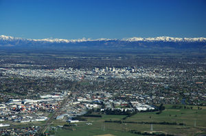
Christchurch (Māori: Ōtautahi) is the largest city in the South Island of New Zealand, and the country's second-largest urban area. It lies one third of the way down the South Island's east coast, just north of Banks Peninsula which itself, since 2006, lies within the formal limits of Christchurch. The city was named by the Canterbury Association, which settled the surrounding province of Canterbury. The name of Christchurch was agreed on at the first meeting of the association on 27 March 1848. It was suggested by John Robert Godley, who had attended Christ Church, Oxford. Some early writers called the town Christ Church, but it was recorded as Christchurch in the minutes of the management committee of the association.[2] Christchurch became a city by Royal Charter on 31 July 1856, making it officially the oldest established city in New Zealand. The river that flows through the centre of the city (its banks now largely forming an urban park) was named Avon at the request of the pioneering Deans brothers to commemorate the Scottish Avon, which rises in the Ayrshire hills near what was their grandfathers' farm and flows into the Clyde.[2] The usual Māori name for Christchurch is Ōtautahi ("the place of Tautahi"). This was originally the name of a specific site by the Avon River near present-day Kilmore Street and the Christchurch Central Fire Station. The site was a seasonal dwelling of Ngāi Tahu chief Te Potiki Tautahi, whose main home was Port Levy on Banks Peninsula. The Ōtautahi name was adopted in the 1930s. Prior to that the Ngāi Tahu generally referred to the Christchurch area as Karaitiana,[3] a transliteration of the English name. On 4 September 2010, a major 7.1 magnitude earthquake struck Christchurch at 4:35 am local time[4], causing an estimated total cost of NZ$4 billion in damage.[5] The epicentre was located approximately 40 kilometres (25 mi) west of the central city, 10 kilometres (6.2 mi) south-east of Darfield.[6]
HistoryOverview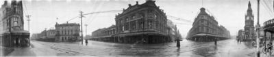
High, Manchester and Lichfield Streets in Christchurch, 1923.
Archeological evidence found in a cave at Redcliffs in 1876 has indicated that the Christchurch area was first settled by moa-hunting tribes about 1250. These first inhabitants were thought to have been followed by the Waitaha tribe, who are said to have migrated from the East coast of the North Island in the 16th century. Following tribal warfare, the Waitaha (made of three peoples) were dispossessed by the Ngati Mamoe tribe. They were in turn subjugated by the Ngāi Tahu tribe, who remained in control until the arrival of European settlers. Following the purchase of land at Putaringamotu (modern Riccarton) by the Weller brothers whalers of Otago and Sydney a party of European settlers led by Herriott and McGillivray established themselves in what is now Christchurch, early in 1840. Their abandoned holdings were taken over by the Deans brothers in 1843 who stayed. The First Four Ships were chartered by the Canterbury Association and brought the first 792 of the Canterbury Pilgrims to Lyttelton Harbour. These sailing vessels were the Randolph, Charlotte-Jane, Sir George Seymour, and Cressy. The Charlotte-Jane was the first to arrive on 16 December 1850. The Canterbury Pilgrims had aspirations of building a city around a cathedral and college, on the model of Christ Church in Oxford.[7] The name "Christ Church" was decided prior to the ships' arrival, at the Association's first meeting, on 27 March 1848. 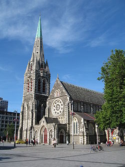
The Anglican cathedral was completed in 1904 and has since been the focal point of the city.
Captain Joseph Thomas, the Canterbury Association's Chief Surveyor, surveyed the surrounding area. By December 1849 he had commissioned the construction of a road from Port Cooper, later Lyttelton, to Christchurch via Sumner.[8] However this proved more difficult than expected and road construction was stopped while a steep foot and pack horse track was constructed over the hill between the port and the Heathcote valley, where access to the site of the proposed settlement could be gained. This track became known as the Bridle Path, because the path was so steep that pack horses needed to be led by the bridle.[9] Goods that were too heavy or bulky to be transported by pack horse over the Bridle Path were shipped by small sailing vessels some eight miles (13 km) by water around the coast and up the estuary to Ferrymead. New Zealand's first public railway line, the Ferrymead railway, opened from Ferrymead to Christchurch in 1863. Due to the difficulties in travelling over the Port Hills and the dangers associated with shipping navigating the Sumner bar, a railway tunnel was bored through the Port Hills to Lyttelton, opening in 1867.[10] Christchurch became a city by Royal Charter on 31 July 1856, the first in New Zealand. Many of the city's Gothic Revival buildings by architect Benjamin Mountfort date from this period. Christchurch was the seat of provincial administration for the Province of Canterbury, which was abolished in 1876. In 1947, New Zealand's worst fire disaster occurred at Ballantyne's Department Store in the inner city, with 41 people killed in a blaze which razed the rambling collection of buildings.[11] The Lyttelton road tunnel between Lyttelton and Christchurch was opened in 1964.[12] Christchurch was host to the 1974 British Commonwealth Games. 2010 EarthquakeMain article: 2010 Canterbury earthquake
An earthquake with magnitude 7.1 occurred in the South Island, New Zealand at Saturday 04:35:44 AM local time, 4 September 2010 (16:35:44 UTC, 3 September 2010).[13] The earthquake occurred at a depth of 16.1 kilometres (10.0 miles). The epicentre was located 40 kilometres (25 mi) west of Christchurch; 10 kilometres (6.2 mi) south-east of Darfield[6]; 190 kilometres (120 mi) south-southeast of Westport; 295 kilometres (183 mi) south-west of Wellington; and 320 kilometres (200 mi) north-northeast of Dunedin.The quakes are occurring parallel to the Waimakariri River and at right angles to the main Alpine fault in a blind fault - one that does not show on the surface. 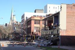
Building damage in Worcester Street, corner Manchester Street, with ChristChurch Cathedral in the background.
Sewers were damaged,[14] gas and water lines were broken, and power to up to 75% of the city was disrupted.[15] Among the facilities impacted by lack of power was the Christchurch Hospital, which was forced to use emergency generators in the immediate aftermath of the quake.[15] A state of emergency was declared at 10:16 am on 4 September for the city, and evacuations of parts were planned to begin later in the day.[16] People inside the Christchurch city centre were evacuated, and the city's central business district will remain closed until Sunday.[17] A curfew from 7 pm on September 4 to 7 am on September 5 has been put in place.[18] The New Zealand Army was also deployed to assist police and search and rescue enforce the curfew.All schools are closed until Wednesday so they can be checked. Christchurch International Airport was closed following the earthquake and flights in and out of it cancelled. It reopened at 1:30 pm following inspection of the main runway.[19] The earthquake was reported to have caused widespread damage and power outages. 63 aftershocks were also reported in the first 48 hours with three registering 5.2 magnitude. Christchurch residents reported chimneys have fallen in through roofs, cracked ceilings and collapsed brick walls.[20] Total Earthquake Commission, insurance and individual costs may reach as high as NZ$4 billion according to the New Zealand Treasury.[5] Gateway to the AntarcticChristchurch has a history of involvement in Antarctic exploration–both Robert Falcon Scott and Ernest Shackleton used the port of Lyttelton as a departure point for expeditions, and there is a statue of Scott, sculpted by his widow, Kathleen Scott, in the central city. Within the city the Canterbury Museum preserves and exhibits many historic artifacts and stories of Antarctic exploration. Christchurch International Airport serves as the major base for the Italian and United States Antarctic programs as well as the New Zealand Antarctic programme. The International Antarctic Centre provides both base facilities and a museum and visitor centre focused upon current Antarctic activities. The United States Navy and latterly the United States Air National Guard, augmented by the New Zealand and Australian air forces, use Christchurch Airport as take-off for the main supply route to McMurdo and Scott Bases in Antarctica. The Clothing Distribution Center (CDC) in Christchurch, has more than 140,000 pieces of extreme cold weather (ECW) gear for issue to nearly 2,000 U.S. Antarctic Program (USAP) participants in the 2007-08 season.[21] Geography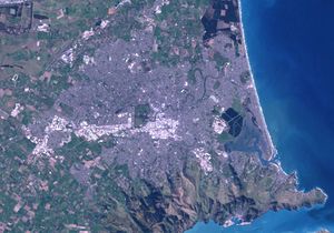
Satellite image showing Christchurch and surrounding areas.
Christchurch lies in Canterbury, near the centre of the east coast of the South Island, east of the Canterbury Plains. It is located near the southern end of Pegasus Bay, and is bounded to the east by the Pacific Ocean coast and the estuary of the Avon and Heathcote Rivers. To the south and south-east the urban portion of the city is limited by the volcanic slopes of the Port Hills separating it from Banks Peninsula. In 2006, Banks Peninsula was incorporated into the city, in effect tripling the city's land area [22] while adding only about 8,000 people to the city's population. To the north the city is bounded by the braided Waimakariri River. Christchurch is one of only eight pairs of cities in the world that has a near-exact antipodal city. Half of these antipodal pairs are in New Zealand and Spain/Morocco–with A Coruña, Spain as Christchurch's antipode. Christchurch has one of the highest-quality water supplies in the world, rated one of the purest and cleanest water in the world.[23] Untreated, naturally filtered water is sourced, via more than 50 pumping stations surrounding the city, from aquifers emanating from the foothills of the Southern Alps.[24] On the morning of Saturday, September 4, 2010 at 4:35am local time, a major 7.0 magnitude earthquake struck, bringing severe damage to the city.[25] Central cityAt the centre of the city is Cathedral Square, surrounding the Anglican cathedral, Christ Church. The area around this square and within the "four avenues" of Christchurch (Bealey Avenue, Fitzgerald Avenue, Moorhouse Avenue and Deans Avenue[26]) is considered the central business district of the city. The central city also has a number of residential areas, including Inner City East, Inner City West, Avon Loop, Moa Neighbourhood & Victoria. Cathedral Square is a popular destination and hosts attractions such as the speakers' corner made famous by the Wizard of New Zealand, Ian Brackenbury Channell, and evangelist Ray Comfort. The central city includes the pedestrianised Cashel Street as Christchurch's urban mall. At one end of the mall stands the Bridge Of Remembrance; at the other end the old location of the amphitheatre known as the Hack Circle. The Cultural Precinct [27] provides a backdrop to a vibrant scene of ever-changing arts, cultural, and heritage attractions within an area of less than one square kilometre. The Arts Centre, the Canterbury Museum and the Art Gallery are located in the Cultural Precinct. The majority of the activities are free and a printable map is provided. Inner suburbs(clockwise, starting north of the city centre)
Outer suburbs(clockwise, starting north of the city centre)
Satellite towns
ClimateChristchurch has a dry, temperate climate, with mean daily maximum air temperatures of 22.5 °C (72.5 °F) in January, 11.3 °C (52.3 °F) in July.[28] Under Koppen's climate classification, Christchurch has an Oceanic climate. The summer climate is often moderated by a sea breeze from the Northeast, but a record temperature of 41.6 °C (107 °F) was reached in February 1973. A notable feature of the weather is the nor'wester, a hot föhn wind that occasionally reaches storm force, causing widespread minor damage to property.[29] In winter it is common for the temperature to fall below 0 °C (32 °F) at night. There are on average 70 days of ground frost per year.[30] Snow falls occur on average once or twice a year in the hill suburbs and about once or twice every two years on the plain. On cold winter nights, the surrounding hills, clear skies, and frosty calm conditions often combine to form a stable inversion layer above the city that traps vehicle exhausts and smoke from domestic fires to cause smog. While not as bad as smog in Los Angeles or Mexico City, Christchurch smog has often exceeded World Health Organisation recommendations for air pollution.[31] The city has funding available to upgrade domestic home heating systems, and in order to limit air pollution has banned the use of open fires as of 1 January 2006. As of 2008, woodburners more than 15 years old are prohibited.[32]
Demographics
Boatsheds on the Avon River
The area administered by the Christchurch City Council has a population of 376,700 (June 2010 estimate),[1] making it the second-largest in New Zealand, and the largest city in the South Island. The Christchurch urban area is the second-largest in the country by population, after Auckland. EthnicityThe following table shows the ethnic profile of Christchurch's population, as recorded in the 2001 and 2006 New Zealand Census. The percentages add up to more than 100%, as some people counted themselves as belonging to more than one ethnic group. Figures for 2006 refer to just Christchurch City, not the whole urban area. The substantial percentage drop in the numbers of 'Europeans' was mainly caused by the increasing numbers of people from this group choosing to define themselves as 'New Zealanders'–even though this was not one of the groups listed on the census form.
The 2006 Census also provides information about the multilinguality of the region. Accordingly, 283,986 people in Christchurch City spoke one language only, while 37,947 spoke two, and 7,881 could converse in three or more languages.[35] EconomyThe agricultural industry has always been the economic core of Christchurch. The city has long had industry based on the surrounding farming country. PGG Wrightson, New Zealand's leading agribusiness, is based in Christchurch. Its local roots go back to Pyne Gould Guinness, an old stock and station agency serving the South Island. That firm helped take deer farming techniques abroad. PGG Wrightson's overseas diversification includes dairy farming in Uruguay. Other agribusinesses in Christchurch have included malting, seed development and dressing, wool and meat processing, and small biotechnology operations using by-products from meat works. Dairying has grown strongly in the surrounding areas with high world prices for milk products and the use of irrigation to lift grass growth on dry land. With its higher labour use this has helped stop declines in rural population. Many cropping and sheep farms have been converted to dairying. Conversions have been by agribusiness companies as well as by farmers, many of whom have moved south from North Island dairying strongholds such as Taranaki and the Waikato. Cropping has always been important in the surrounding countryside. Wheat and barley and various strains of clover and other grasses for seed exporting have been the main crops. These have all created processing businesses in Christchurch. In recent years, regional agriculture has diversified, with a thriving wine industry springing up at Waipara, and beginnings of new horticulture industries such as olive production and processing. Deer farming has led to new processing using antlers for Asian medicine and aphrodisiacs. The high quality local wine in particular has increased the appeal of Canterbury and Christchurch to tourists. In earlier years, Christchurch was one of the two heavy-engineering centres of New Zealand, with firms such as Anderson's making steel work for bridges, tunnels, and hydro-electric dams in the early days of infrastructure work. Now manufacturing is mainly of light products and the key market is Australia, with firms such as those pioneered by the Stewart family among the larger employers. Before clothing manufacture largely moved to Asia, Christchurch was the centre of the New Zealand clothing industry, with firms such as LWR Industries. The firms that remain mostly design and market, and manufacture in Asia. The city also had five footwear manufacturers, but these have been replaced by imports. In the last few decades, technology-based industries have sprung up in Christchurch. Angus Tait founded Tait Electronics, a mobile-radio manufacturer, and other firms spun off from this, such as Dennis Chapman's Swichtec. Tait proteges include Chapman. In software, Gil Simpson founded LINC, which became Jade. Neither Angus nor Gil completed high school education. However, there have been spin-offs from the electrical department of the University of Canterbury engineering school. These included Pulse Data, which became Human Ware ( making reading devices and computers for blind people and those with limited vision) and CES Communications (encryption). The Pulse Data founders had moved from the Canterbury University engineering school to work for Wormald when they set up Pulse Data through a management buyout of their division. Nowadays, the University of Canterbury engineering school and computer science department play an important role in supplying staff and research for the technology industries, and the Christchurch Polytechnic Institute of Technology provides a flow of trained technicians and engineers. Similarly, nearby Lincoln University has played an important role in Christchurch agribusiness. Tourism is also a significant factor of the local economy. The closeness of the ski-fields and other attractions of the Southern Alps, and hotels, a casino, and an airport that meet international standards make Christchurch a stopover destination for many tourists. The city is popular with Japanese tourists,[36] with signage around Cathedral Square in Japanese. Government
The coat of arms of the City of Christchurch, New Zealand.
Christchurch's local government is a democracy with various elements including:
In 1993, Christchurch was selected as the "Best Run City in the World", also known as the 'Carl Bertelsmann Prize: Local Government', by the Bertelsmann Foundation of Germany. Especially noted was the increased efficiency of communal services in competition with private enterprises. Christchurch shared the award honour with Phoenix, Arizona, USA.[39] Some of the local governments in Canterbury and the New Zealand Transport Agency have created the Greater Christchurch Urban Development Strategy to facilitate future urban planning.[40] EducationSecondary schoolsChristchurch is the location of Burnside High School, the second largest school in New Zealand with 2,788 pupils. Cashmere High School at Rose Street is another large co-educational secondary school. In recent years, Papanui High School has undergone rapid growth to reach a similar size. Riccarton High School was one of the first state schools in the country to adopt a strong values base - the Riccarton Way. Christchurch is also well-known for several very traditional schools of the English public school type, such as St Margaret's College, Christ's College, St Andrew's College, Villa Maria College and Rangi Ruru Girls' School, but also has several less conventional schools such as Unlimited Paenga Tawhiti and Hagley Community College. Tertiary institutions
The University of Canterbury is a tertiary education provider for Christchurch
A number of tertiary education institutions have campuses in Christchurch, or in the surrounding areas.
TransportChristchurch is served by Christchurch International Airport and by buses (local and long-distance) and trains. The local bus service, known as Metro, is provided by Environment Canterbury. The car, however, remains the dominant form of transport. The central city has very flat terrain and the Christchurch City Council is establishing a network of cycle lanes and paths.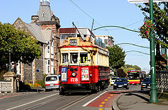
Christchurch Brill Tram No 178 on the heritage tramway
There is a functioning tram service in Christchurch, but as a tourist attraction; its loop is restricted to a circuit of the central city. The trams were originally introduced in 1905, ceased operating in 1954,[41] but returned to the inner city (as a tourist attraction) in 1995. In addition to normal bus services, Christchurch also has a pioneering zero-fare hybrid bus service, the Shuttle, in the inner city. The Main North Line railway travels northwards via Kaikoura to Picton and is served by the famous TranzCoastal passenger train, while the Main South Line heads to Invercargill via Dunedin and was used by the Southerner until its cancellation in 2002. The most famous train to depart Christchurch is the TranzAlpine, which travels along the Main South Line to Rolleston and then turns onto the Midland Line, passes through the Southern Alps via the Otira Tunnel, and terminates in Greymouth on the West Coast. This trip is often regarded to be one of the ten great train journeys in the world for the amazing scenery through which it passes. The TranzAlpine service is primarily a tourist service and carries no significant commuter traffic. Commuter trains used to operate in Christchurch but were progressively cancelled in the 1960s and 1970s. The last such service, between Christchurch and Rangiora, ceased in 1976. Vehicles, as they do throughout New Zealand and all Commonwealth Nations, drive on the left side of the road. Visitor attractions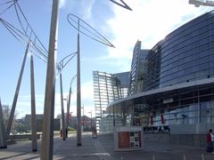
The Christchurch Art Gallery
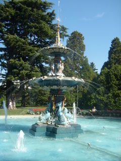
Water fountain at Christchurch Botanical Gardens.
EntertainmentParks and natureThe large number of public parks and well-developed residential gardens with many trees has given Christchurch the name of The Garden City.[42] Hagley Park and the 30-hectare (75 acre) Christchurch Botanic Gardens, founded in 1863, are in the central city, with Hagley Park being a site for sports such as golf, cricket, netball, and rugby, and for open air concerts by local bands and orchestras. To the north of the city is the Willowbank wildlife park. Travis Wetland, an ecological restoration programme to create a wetland, is to the east of the city centre in the suburb of Burwood. CinemaWhile historically most cinemas were grouped around Cathedral Square,[43] only two cinemas remain there. The Regent complex was rebuilt as 'Regent on Worcester' in 1996. In 2009 Metro Cinemas opened in Worcester Street with three screens. Only one of the first generation of suburban cinemas, the Hollywood in Sumner, remains open.[44] The largest multiplexes are the Hoyts 8 in the old railway station on Moorhouse Avenue and Reading Cinemas (also eight screens) in the Palms shopping centre in Shirley. Hoyts in Riccarton opened in 2005[45] with one of its screens for a time holding the record for the largest in New Zealand. The Rialto Cinemas on Moorhouse avenue specialise in international films and art house productions. The Rialto also hosts the majority of the city's various film festivals and is home to the local film society. The Christchurch Arts Centre includes two art house cinemas, Cloisters and The Academy, screening a wide selection of contemporary, classic and foreign language films. The Canterbury Film Society is active in the city.[46] TheatreChristchurch has one full-time professional theatre, the Court Theatre,[47] which is based in the Christchurch Arts Centre. There is also an active recreational theatre scene with community based theatre companies, such as the Riccarton Players,[48] Elmwood Players,[49] and Canterbury Children's Theatre,[50] producing many quality shows. MusicThe city is known for its many live acts,[51][52] has a professional symphony orchestra,[53] and is the base of professional opera company, Southern Opera.[54] There are usually buskers around the town square, and Christchurch also hosts the World Buskers Festival in January each year. Christchurch also has an active and relatively large Metal scene, with metal acts playing in various locations around the central city almost weekly. In recent movements, hip hop has effectively landed in Christchurch. In 2000, First Aotearoa Hip Hop Summit was held there. And in 2003, Christchurch’s own Scribe, released his debut album in New Zealand and has received five times platinum in that country, in addition to achieving two number one singles.[55][56] TelevisionChristchurch has its own regional television station Canterbury Television. CTV was first formed in 1991 and still today reflects the Canterbury community through locally made programmes. Venues
Christchurch Casino with its playful hybrid of old and new architectural forms
The CBS Canterbury Arena is New Zealand's second largest permanent multipurpose arena, seating between 5000 and 8000, depending on configuration. It is home of the Canterbury Tactix netball side. It was the venue for the 1999 World Netball championships and has been host to many concerts in recent years. The Christchurch Town Hall auditorium (2500 seats, opened 1972) was the first major auditorium design by architects Warren and Mahoney and acousticians Marshall Day. It is still recognised as a model example of concert-hall design. It has an excellent modern pipe organ. Christchurch also has a casino,[57] and there are also a wide range of live music venues[58][59]–some short-lived, others with decades of history. Classical music concerts are held at the Christchurch Music Centre. SportTeams
Events
Venues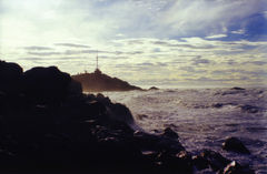
Winter afternoon on the Christchurch coast.
Sister citiesChristchurch has seven sister cities around the world. They are:[61]
See also
References
Bibliography
External linksOfficial organisations
Culture & information
Tourism & maps
|
|||||||||||||||||||||||||||||||||||||||||||||||||||||||||||||||||||||||||||||||||||||||||||||||||||||||||||||||||||||||||||||||||||||||||||||||||||||||||||||||||||||||||||||||||||||||||||||||||||||||||||||||||||||||||||||||||||||||||||||||||||||||||||||||||||||||||||||||||||||||||||||||