Dunedin
| Dunedin Māori: Ōtepoti |
|||
|---|---|---|---|
| — Metropolitan Area — | |||
 |
|||
|
|||
| Nickname(s): Edinburgh of the South[1] Dunners (colloquial)[2] |
|||
 Dunedin
|
|||
| Coordinates: | |||
| Country | |||
| Region | Otago | ||
| Territorial authority | Dunedin City | ||
| Settled by Māori | c. 1300[3] | ||
| Settled by Europeans | 1848 | ||
| Incorporated[4] | 1855 | ||
| Named for | Dùn Èideann - Scottish Gaelic name for Edinburgh | ||
| Electorates | Dunedin North Dunedin South |
||
| Government[5] | |||
| - Mayor | Peter Chin | ||
| Area | |||
| - Territorial | 3,314 km2 (1,279.5 sq mi) | ||
| - Urban | 255 km2 (98.5 sq mi) | ||
| Population (June 2010 estimate)[6] | |||
| - Territorial | 124,800 | ||
| - Density | 37.7/km2 (97.5/sq mi) | ||
| - Urban | 116,600 | ||
| - Urban density | 457.3/km2 (1,184.3/sq mi) | ||
| Demonym | Dunedinite | ||
| Time zone | NZST (UTC+12) | ||
| - Summer (DST) | NZDT (UTC+13) | ||
| Postcode | 9010, 9011, 9012, 9013, 9014, 9016, 9018, 9022, 9023 | ||
| Area code(s) | 03 | ||
| Website | http://www.dunedin.govt.nz/ | ||

Dunedin (/dəˈniːdɪn/), (Māori: Ōtepoti) is the second-largest city in the South Island of New Zealand, and the principal city of the Otago Region. It is also considered to be one of the four main urban centres for historic, cultural, and geographic reasons. The city has a population of 124,800 (June 2010 estimate), is the seventh-largest urban area in New Zealand, and is the largest city by territorial land area (although it will be superseded by Auckland on the creation of the Auckland Council in November 2010).
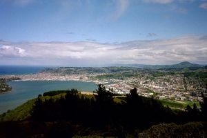
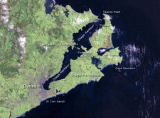
The Dunedin urban area lies on the central-eastern coast of Otago, surrounding the head of Otago Harbour. The harbour and hills around Dunedin are the remnants of an extinct volcano. The city suburbs extend out into the surrounding valleys and hills, onto the isthmus of the Otago Peninsula, and along the shores of the Otago Harbour and the Pacific Ocean.
The city's largest industry is tertiary education – Dunedin is home to the University of Otago, New Zealand's first university (1869), and the Otago Polytechnic. The University accounts for about 20 percent of the city's population.
Contents |
History
Māori settlements
Archaeological evidence shows the first human (Māori) occupation of New Zealand occurred between AD 1250–1300,[3] with population concentrated along the southeast coast.[7] A camp site at Kaikai's Beach, near Otago Heads, has been dated from about that time.[8] There are numerous archaic (moa hunter) sites in what is now Dunedin, several of them large and permanently occupied, particularly in the fourteenth century.[9] The population contracted but expanded again with the evolution of the Classic culture which saw the building of several pā, fortified settlements, notably Pukekura at (Taiaroa Head), about 1650.[10] There was a settlement in what is now central Dunedin (Ōtepoti) occupied as late as about 1785 but abandoned by 1826.[11]
Maori tradition tells first of a people called Kahui Tipua living in the area, then Te Rapuwai, semi-legendary but considered to be historical. The next arrivals were Waitaha followed by Kāti Mamoe late in the sixteenth century and then Kai Tahu (Ngai Tahu in modern standard Māori) who arrived in the mid seventeenth century.[12] These migration waves have often been represented as 'invasions' in European accounts but modern scholarship has cast doubt on that. They were probably migrations like those of the European which incidentally resulted in bloodshed.[13]
The sealer John Boultbee recorded in the 1820s that the 'Kaika Otargo' (settlements around and near Otago Harbour) were the oldest and largest in the south.[14]
European settlement
Lieutenant James Cook stood off what is now the coast of Dunedin between February 25, 1770 and March 5, 1770, naming Cape Saunders on the Otago Peninsula and Saddle Hill. He reported penguins and seals in the vicinity, which led sealers to visit from the beginning of the 19th century.[15] The early years of sealing saw a feud between sealers and local Maori, from 1810–1823, the "Sealers' War" sparked by an incident on Otago Harbour, but William Tucker became the first European to settle in the area in 1815.[16] Permanent European occupation dates from 1831 when the Weller brothers founded their whaling station at Otago, modern Otakou, on the Otago Harbour. Epidemics badly reduced the Maori population. By the late 1830s, the harbour was an international whaling port. Johnny Jones established a farming settlement and a mission station, the South Island's first, at Waikouaiti in 1840.[17]
In 1844, the Deborah, captained by Thomas Wing and carrying, among others his wife Lucy and a representative of the New Zealand Company, Frederick Tuckett, came south to determine the location of a free church settlement.[18] After inspecting several areas around the eastern coast of the south island, Tuckett selected the site which would become known as Dunedin.[19]
The Lay Association of the Free Church of Scotland founded Dunedin at the head of Otago Harbour in 1848 as the principal town of its special settlement. The name comes from Dùn Èideann, the Scottish Gaelic name for Edinburgh, the capital of Scotland.[12] Charles Kettle the city's surveyor, instructed to emulate the characteristics of Edinburgh, produced a striking, 'Romantic' design.[20] The result was both grand and quirky streets as the builders struggled and sometimes failed to construct his bold vision across the challenging landscape. Captain William Cargill, a veteran of the war against Napoleon, was the secular leader. The Reverend Thomas Burns, a nephew of the poet Robert Burns, was the spiritual guide.
Gold rush era
In 1852, Dunedin became the capital of the Otago Province, the whole of New Zealand from the Waitaki south. In 1861 the discovery of gold at Gabriel's Gully, to the southwest, led to a rapid influx of population and saw Dunedin become New Zealand's first city by growth of population in 1865. The new arrivals included many Irish, but also Italians, French, Germans, Jews and Chinese.[21] The Dunedin Southern Cemetery was established in 1858, the Dunedin Northern Cemetery in 1872.[22]
Dunedin and the region industrialised and consolidated and the Main South Line connected the city with Christchurch in 1878 and Invercargill in 1879. The University of Otago, the oldest university in New Zealand, was founded in Dunedin in 1869.[23] Otago Girls' High School was founded in 1871. Between 1881 and 1957, Dunedin was home to cable trams, being both one of the first and last such systems in the world. Early in the 1880s the inauguration of the frozen meat industry, with the first shipment leaving from Port Chalmers in 1882, saw the beginning of a later great national industry.[24]
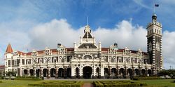
After ten years of gold rushes the economy slowed but Julius Vogel's immigration and development scheme brought thousands more especially to Dunedin and Otago before recession set in again in the 1880s. In these first times of prosperity many institutions and businesses were established, New Zealand's first daily newspaper, art school, medical school and public art gallery the Dunedin Public Art Gallery among them.[25] There was also a remarkable architectural flowering producing many substantial and ornamental buildings. R.A. Lawson's First Church of Otago and Knox Church are notable examples, as are buildings by Maxwell Bury and F.W. Petre. The other visual arts also flourished under the leadership of W. M. Hodgkins.[26] The city's landscape and burgeoning townscape were vividly portrayed by George O'Brien 1821–1888.[27] From the mid 1890s the economy revived. Institutions such as the Otago Settlers Museum and the Hocken Collections – the first of their kind in New Zealand – were founded. More notable buildings such as the Railway Station and Olveston were erected. New energy in the visual arts represented by G.P. Nerli culminated in the career of Frances Hodgkins.[28]
Early Modern era
By 1900, Dunedin was no longer the country's biggest city. Influence and activity moved north to the other centres ("the drift north"), a trend which continued for much of the following century. Despite this, the university continued to expand, and a student quarter became established. At the same time people started to notice Dunedin's mellowing, the ageing of its grand old buildings, with writers like E.H. McCormick pointing out its atmospheric charm.[29] In the 1930s and early 1940s a new generation of artists such as M.T. (Toss) Woollaston, Doris Lusk, Anne Hamblett, Colin McCahon and Patrick Hayman once again represented the best of the country's talent. The Second World War saw the dispersal of these painters, but not before McCahon had met a very youthful poet, James K. Baxter, in a central city studio.
Numerous large companies had been established in Dunedin, many of which became national leaders. Late among them was Fletcher Construction, founded by Sir James Fletcher in the early 20th century. Kempthorne Prosser, established in 1879 in Stafford Street, was the largest fertiliser and drug manufacturer in the country for over 100 years. G. Methven, a metalworking and tap manufacturer based in South Dunedin, was also a leading firm, as was H. E. Shacklock, an iron founder and appliance manufacturer later taken over by the Auckland concern Fisher and Paykel. The Mosgiel Woollens was another Victorian Dunedin foundation. Hallensteins was the colloquial name of a menswear manufacturer and national retail chain while the DIC and Arthur Barnett were department stores, the former a nationwide concern. Coulls, Somerville Wilkie – later part of the Whitcoulls group – had its origins in Dunedin in the 19th century. There were also the National Mortgage and Agency Company, Wright Stephensons Limited, the Union Steamship Company and the National Insurance Company and the Standard Insurance Company among many others, which survived into the 20th century.
Post War developments

After World War II prosperity and population growth revived, although Dunedin trailed as the fourth 'main centre'. A generation reacting against Victorianism started demolishing its buildings and many were lost, notably William Mason's Stock Exchange in 1969. (Dunedin Stock Exchange building) Although the university continued to expand, the city's population growth slowed and then contracted, notably from 1976 to 1981. This was, however, a culturally vibrant time with the university's new privately endowed arts fellowships bringing such luminaries as James K Baxter, Ralph Hotere, Janet Frame, and Hone Tuwhare to the city.
During the 1980s Dunedin's popular music scene blossomed, with many acts, such as The Chills, The Clean, The Verlaines, and Straitjacket Fits, gaining national and international recognition. The term "The Dunedin Sound" was coined to describe the 1960s-influenced, guitar-led music which flourished at the time.[30] The music scene continues to thrive , with bands and musicians playing and recording in many styles, from electronica to reggae to folk.
By 1990, population decline had steadied and Dunedin had re-invented itself as a 'heritage city' with its main streets refurbished in Victorian style[31] and R.A. Lawson's Municipal Chambers (Dunedin Town Hall) in the Octagon handsomely restored. The city was also recognised as a centre of excellence in tertiary education and research. The university's and polytechnic's growth accelerated. Dunedin has continued to refurbish itself, embarking on redevelopments of the art gallery railway station and the Otago Settlers Museum.
The city has flourishing niche industries including engineering, software engineering, bio-technology and fashion. Port Chalmers on the Otago Harbour provides Dunedin with deep-water facilities. It is served by the Port Chalmers Branch, a branch line railway which diverges from the Main South Line and runs from Christchurch by way of Dunedin to Invercargill.
The cityscape glitters with gems of Victorian and Edwardian architecture – the legacy of the city's gold-rush affluence. Many, including First Church, Otago Boys' High School and Larnach Castle were designed by one of New Zealand's most eminent architects R A Lawson. Other prominent buildings include Olveston and the Dunedin Railway Station. Other unusual or memorable buildings or constructions are Baldwin Street, the world's steepest street; the Captain Cook tavern; Cadbury Chocolate Factory (Cadbury World); and the local Speight's brewery.
Dunedin is also a centre for ecotourism. The world's only mainland Royal Albatross colony and several penguin and seal colonies lie within the city boundaries on the Otago Peninsula. To the south, on the western side of Lake Waihola, are the Sinclair Wetlands.
The thriving tertiary student population has led to a vibrant youth culture (students are referred to as 'Scarfies' by people who aren't students), consisting of the previously mentioned music scene, and more recently a burgeoning boutique fashion industry.[32][33] A strong visual arts community also exists in Dunedin and its environs, notably in Port Chalmers and the other settlements which dot the coast of the Otago Harbour, and also in communities such as Waitati.
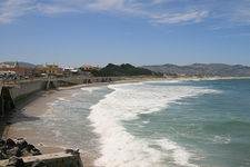
Sport is catered for in Dunedin by the floodlit rugby and cricket venue of Carisbrook, the new Caledonian Groundsoccer and athletics stadium near the University at Logan Park, the large Edgar Centre indoor sports centre, the University Oval cricket ground, the Dunedin Ice Stadium, and numerous golf courses and parks. There are also the Forbury Park horseracing circuit in the south of the city and several others within a few kilometres. St Clair Beach is a well-known surfing venue, and the harbour basin is popular with windsurfers and kitesurfers. Dunedin has four public swimming pools: Moana Pool, Port Chalmers Pool, Mosgiel, and St Clair Salt Water Pool.
Geography
Dunedin City has a land area of 3,314.8 square kilometres (1,279.9 sq mi), slightly smaller than the American state of Rhode Island or the English county of Cambridgeshire, and a little smaller than Cornwall. It is currently the largest city in land area in New Zealand, but will be beaten by Auckland on the formation of the 5,600 km2 (2,200 sq mi) Auckland Council on 1 November 2010. The Dunedin City Council boundaries since 1989 have extended to Middlemarch in the west, Waikouaiti in the north, the Pacific Ocean in the east and south-east, and the Waipori/Taieri River and the township of Henley in the south-west.
Dunedin is the most remote city in the world from London at 19,100 km (11,870 mi) (90 km (56 mi) more than Invercargill, and 100 km (62 mi) more than Christchurch), and from Berlin at 18,200 km (11,310 mi). Its antipodes are some 300 km (190 mi) north of the Spanish city of A Coruña, in the Bay of Biscay.
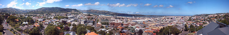
Inner city
The heart of the city lies on the relatively flat land to the west of the head of the Otago Harbour. Here is The Octagon – once a gully, filled in the mid nineteenth century to create the present plaza. The initial settlement of the city took place to the south on the other side of Bell Hill, a large outcrop which had to be reduced in order to provide easy access between the two parts of the settlement. The central city stretches away from this point in a largely northeast-southwest direction, with the main streets of George Street and Princes Street meeting at The Octagon. Here they are joined by Stuart Street, which runs orthogonal to them, from the Dunedin Railway Station in the southeast, and steeply up to the suburb of Roslyn in the northwest. Many of city's notable old buildings are located in the southern part of this area and on the inner ring of lower hills which surround the central city (most of these hills, such as Maori Hill, Pine Hill, and Maryhill, rise to some 200 metres (660 ft) above the plain).
Dunedin is home to Baldwin Street, which, according to the Guinness Book of Records, is the steepest street in the world. Its gradient is 1 in 2.9.[34] The long since abandoned Maryhill Cablecar route had a similar gradient close to its Mornington depot.
Beyond the inner range of hills lie Dunedin's outer suburbs, notably to the northwest, beyond Roslyn. This direction contains Taieri Road and Three Mile Hill, which between them formed the original road route to the Taieri Plains. The modern State Highway 1 follows a different route, passing through Caversham in the west and out past Saddle Hill. Lying between Saddle Hill and Caversham are the outer suburbs of Green Island and Abbotsford. Between Green Island and Roslyn lies the steep-sided valley of the Kaikorai Stream, which is today a residential and light industrial area. Suburban settlements – mostly regarded as separate townships – also lie along both edges of the Otago Harbour. Notable among these are Portobello and Macandrew Bay, on the Otago Peninsula coast, and Port Chalmers on the opposite side of the harbour. Port Chalmers provides Dunedin's main deep-water port, including the city's container port.
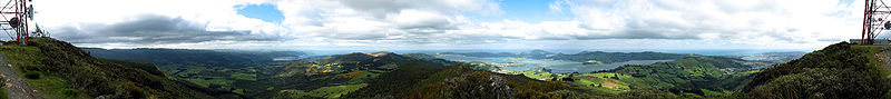
The Dunedin skyline is dominated by a ring of (traditionally seven) hills which form the remnants of a volcanic crater. Notable among them are Mount Cargill (700 m/2,300 ft), Flagstaff (680 m/2,230 ft), Saddle Hill (480 m/1,570 ft), Signal Hill (390 m/1,280 ft), and Harbour Cone (320 m/1,050 ft).[35]
Hinterland
The hinterland of Dunedin city encompasses a variety of different landforms. To the southwest lie the Taieri Plains, the broad, fertile lowland floodplains of the Taieri River and its major tributary the Waipori. These are moderately heavily settled, and contain the towns of Mosgiel, East Taieri, and Allanton.[35] They are separated from the coast by a range of low hills rising to some 300 metres (980 ft). Inland from the Taieri Plain is rough hill country. Close to the plain, much of this is forested, notably around Berwick and Lake Mahinerangi, and also around the Silverpeaks Range which lies northwest of the Dunedin urban area.[36] Beyond this, the land becomes drier and opens out into grass and tussock-covered land. A high, broad valley, the Strath-Taieri lies in Dunedin's far northwest, containing the town of Middlemarch, one of the area's few concentrations of population.
To the north of the city's urban area is undulating hill country containing several small, mainly coastal, settlements, including Waitati, Warrington, Seacliff and Waikouaiti. State Highway 1 winds steeply through a series of hills here, notably The Kilmog.[35] These hills can be considered a coastal extension of the Silverpeaks Range.
To the east, Dunedin City includes the entirety of the Otago Peninsula, a long finger of land that formed the southeastern rim of the Dunedin Volcano.[35] The peninsula is lightly settled, almost entirely along the harbour coast, and much of it is maintained as a natural habitat by the Otago Peninsula Trust. The peninsula contains several fine beaches, and is home to a considerable number of rare species, such as penguins, seals, and shags. Most importantly, it contains the world's only mainland breeding colony of Royal Albatross, at Taiaroa Head on the peninsula's northeastern point.
List of suburbs
Inner suburbs
(clockwise from the city centre, starting at due north)
Woodhaugh; Glenleith; Leith Valley; Dalmore; Liberton; Pine Hill; Normanby; Mt Mera; North East Valley; Opoho; Dunedin North; Ravensbourne; Highcliff; Shiel Hill; Challis; Waverley; Vauxhall; Ocean Grove (Tomahawk); Tainui; Andersons Bay; Musselburgh; South Dunedin; St Kilda; St Clair; Corstorphine; Kew; Forbury; Caversham; Concord; Maryhill; Kenmure; Mornington; Kaikorai Valley; City Rise; Belleknowes; Roslyn, Otago; Kaikorai; Wakari; Maori Hill.
Outer suburbs
(clockwise from the city centre, starting at due north)
Burkes; Saint Leonards; Broad Bay; Company Bay; Macandrew Bay; Burnside; Green Island; Waldronville; Saddle Hill; Sunnyvale; Fairfield; Abbotsford; Bradford; Brockville; Halfway Bush; Helensburgh.
Towns within city limits
(clockwise from the city centre, starting at due north)
Waitati; Waikouaiti; Karitane; Seacliff; Warrington; Purakanui; Long Beach; Aramoana; Deborah Bay; Careys Bay; Port Chalmers; Sawyers Bay; Roseneath; Otakou; Portobello; Brighton; Taieri Mouth; Henley; Allanton; East Taieri; Momona; Outram; Mosgiel; West Taieri; Waipori; Middlemarch; Hyde.
Since local council reorganisation in the late 1980s, these are suburbs, but are not commonly regarded as such.
Climate
The climate of Dunedin in general is temperate, however the city is recognised as having a large number of microclimates and the weather conditions often vary between suburbs mostly due to the city's topographical layout. It is also greatly modified by its proximity to the ocean. This leads to warm summers and cool winters. Winter can be frosty, but significant snowfall is uncommon (perhaps every two or three years), except in the inland hill suburbs such as Halfway Bush and Wakari, which tend to receive a few days of snowfall each year. Spring can feature "four seasons in a day" weather, but from November to April it is generally settled and mild. Temperatures during summer can reach 30 °C (86 °F), but temperatures in the high 20s are rare.
Dunedin has relatively low rainfall in comparison to many of New Zealand's cities, with only some 750 millimetres (30 in) recorded per year. Despite this fact it is regarded by many as a damp city, probably due to its rainfall occurring in drizzle over a larger number of days (northern centres such as Auckland and Wellington receive more rain overall through heavy downpours on relatively fewer days). Dunedin is one of the cloudiest centres in the country, recording approximately 1650 hours of bright sunshine per annum[37] Prevailing winds in the city come from two directions, with cool, damp southwesterlies tending to alternate with northeasterlies.[38] Warmer, dry northwest winds are also characteristic Foehn winds from the northwest. The circle of hills surrounding the inner city shelters the inner city from much of Otago's prevailing weather, often resulting in the main urban area having completely different weather conditions to the rest of Otago.
Inland, beyond the heart of the city, the climate is sub-continental: winters are quite cold and dry, summers hot and dry. Thick freezing ground fogs are common in winter in the upper reaches of the Taieri River's course around Middlemarch, and in summer the temperature frequently reaches into the mid-30s Celsius.
| Climate data for Dunedin | |||||||||||||
|---|---|---|---|---|---|---|---|---|---|---|---|---|---|
| Month | Jan | Feb | Mar | Apr | May | Jun | Jul | Aug | Sep | Oct | Nov | Dec | Year |
| Average high °C (°F) | 18.9 (66) |
18.7 (65.7) |
17.2 (63) |
15.5 (59.9) |
12.6 (54.7) |
10.2 (50.4) |
9.8 (49.6) |
11.0 (51.8) |
12.8 (55) |
14.6 (58.3) |
16.1 (61) |
17.4 (63.3) |
14.6 (58.3) |
| Daily mean °C (°F) | 15.2 (59.4) |
15.1 (59.2) |
13.7 (56.7) |
11.9 (53.4) |
9.2 (48.6) |
7.0 (44.6) |
6.5 (43.7) |
7.5 (45.5) |
9.3 (48.7) |
10.9 (51.6) |
12.4 (54.3) |
13.9 (57) |
11.0 (51.8) |
| Average low °C (°F) | 11.5 (52.7) |
11.4 (52.5) |
10.2 (50.4) |
8.3 (46.9) |
5.7 (42.3) |
3.8 (38.8) |
3.2 (37.8) |
4.1 (39.4) |
5.7 (42.3) |
7.2 (45) |
8.6 (47.5) |
10.4 (50.7) |
7.5 (45.5) |
| Rainfall mm (inches) | 72 (2.83) |
63 (2.48) |
70 (2.76) |
60 (2.36) |
72 (2.83) |
74 (2.91) |
69 (2.72) |
65 (2.56) |
53 (2.09) |
71 (2.8) |
63 (2.48) |
82 (3.23) |
812 (31.97) |
| Avg. rainy days (≥ 1mm) | 10 | 8 | 10 | 9 | 11 | 10 | 11 | 11 | 10 | 11 | 11 | 12 | 124 |
| Sunshine hours | 178 | 153 | 140 | 121 | 100 | 86 | 101 | 114 | 129 | 147 | 161 | 169 | 1,585 |
| Source: NIWA CliFlo data Musselburgh[39] | |||||||||||||
Demographics
Compared to New Zealand as a whole, Dunedin's demographics tend to show traits of the New Zealand education sector, largely caused by the city's high tertiary student population. These traits include a higher female population compared to males, a lower-than-average median age, a high proportion of people under 25 years, a higher proportion of people of European and Asian ethnicity and a lower proportion of Maori and Pacific Island ethnicities, higher unemployment, lower median income, and a higher proportion of those with school and post-school qualifications.[40]
At the 2006 census, Dunedin City had a residential population of 118,683, an increase of 4,341, or 3.8 percent, since the 2001 census. There were 45,072 occupied dwellings, 3,615 unoccupied dwellings, and 240 dwellings under construction.[40]
Of the residential population, 56,931 (48.0%) were male compared to 48.8% nationally, and 61,752 (52.0%) were female, compared to 51.2% annually. The city had a median age of 35.0 years, 0.9 years below the national median age of 35.9 years. People aged 65 and over made up 13.4% of the population, compared to 12.3% nationally, and people under 15 years made up 16.8%, compared to 21.5% nationally. Due to the large tertiary education sector, people aged between 15 and 24 made up approximately 22% of the city's residential population.[40]
Dunedin's ethnicity is made up of (national figures in brackets): 78.7% European (67.6%), 6.4% Maori (14.7%), 5.3% Asian (9.2%), 2.2% Pacific Islanders (6.9%), 0.7% Middle Eastern/Latin American/African (0.9%), 13.6% 'New Zealanders' (11.1%), and 0.04% Other (0.04%).[40]
Dunedin had an unemployment rate of 6.1% of people 15 years and over, compared to 5.1% nationally. The median annual income of all people 15 years and over was $19,400, compared to $24,400 nationally. Of those, 51.2% earned under $20,000, compared to 43.2% nationally, while 13.4% earned over $50,000, compared to 18.0% nationally.[40]
Government
Local
The Dunedin City Council (DCC) governs the Dunedin City territorial authority. It is made up of an elected mayor, a deputy mayor/councillor, and 13 additional councillors. They are elected under the Single Transferable Vote system in triennial elections, with the next election being held on Saturday 9 October 2010.
The Mayor of Dunedin is elected at large, while the fourteen councillors are elected from one of six wards: Cargill (central city and northern suburbs), Hills (western suburbs), Green Island - Saddle Hill (southwestern suburbs and associated rural area), Mosgiel - Taieri (Mosgiel and western rural areas), South Dunedin (southeastern suburbs and the Otago Peninsula), and Waikouaiti Coast-Chalmers (Port Chalmers area and northern rural area)
As of April 2010, the current council members are:-
| Mayor | Peter Chin |
| Councillors - Cargill ward | Paul Hudson Michael Guest Teresa Stevenson |
| Councillors - Hills ward | Fliss Butcher Chris Staynes Richard Walls |
| Councillor - Green Island-Saddle Hill ward | Colin Weatherall |
| Councillors - Mosgiel-Taieri ward | Syd Brown (Deputy Mayor) Kate Wilson |
| Councillors - South Dunedin ward | Bill Acklin John Bezett Neil Collins Dave Cull |
| Councillor - Waikouaiti Coast-Chalmers ward | Andrew Noone |
At the 2010 elections, the Cargill, Hills, Green Island-Saddle Hill, and South Dunedin wards will merge to form an 11-member Central ward, covering the entire city and the Otago Peninsula.
National
Dunedin is covered by two general electorates: Dunedin North and Dunedin South, and one Maori electorate: Te Tai Tonga.
As of the 2008 general election, both Dunedin North and Dunedin South are held by MPs of the opposing Labour Party, with Pete Hodgson representing Dunedin North and Clare Curran representing Dunedin South. The Maori electorate Te Tai Tonga, which covers the entire South Island and part of Wellington in the North Island, is currently held by the Maori Party and represented by Rahui Katene.
In addition to electorate MPs, Dunedin is the home of two list MPs: Michael Woodhouse of the governing National Party, and Metiria Turei, co-leader of the Green Party.
Media
The major daily newspaper is the Otago Daily Times, which is also the country's oldest daily newspaper and part of the Allied Press group. Weekly and bi-weekly community newspapers include The Star, Taieri Herald, D Scene, f*INK (entertainment), and student magazine Critic.
The city is served by all major national radio and television stations, with terrestrial television (both analogue and Freeview|HD) and FM radio broadcasting from Mount Cargill, north of the city. Local radio stations include Radio Dunedin, and the university's radio station Radio One. The city has one local television station, Channel 9, part of Allied Press.
The city was once home to the head offices of Radio Otago, today called Radioworks (part of Mediaworks) - now based in Auckland.
Transport
The Dunedin urban area is served by two State Highways, with an additional two State Highways and one tourist route serving other parts of the district. The main State Highway in Dunedin is State Highway 1, which runs in a north to south-west direction through the middle of the city, connecting Dunedin with Invercargill to the south and Timaru and Christchurch to the north. Between Lookout Point and Mosgiel, State Highway 1 follows the eleven-kilometre Dunedin Southern Motorway. Other State Highways in the city and district are: State Highway 86 connecting SH 1 at Allanton with Dunedin International Airport, State Highway 87 connecting SH 1 at Mosgiel with SH 85 at Kyeburn via Middlemarch, serving the Dunedin city hinterland, and State Highway 88 connecting central Dunedin to Port Chalmers. Dunedin is the northeastern terminus of the Southern Scenic Route, a tourist highway connecting Dunedin to Te Anau via The Catlins, Invercargill and Fiordland.

Buses in Dunedin are organised by the Otago Regional Council under the GoBus brand. A total of 59 buses operate on 17 weekday routes and 13 weeknight/weekend/holiday routes across the city. Buses are run by two operators, Dunedin City Council-owned operator Citibus (10/11 routes) and private Invercargill-based operator Passenger Transport (7/2 routes). In addition, Mosgiel Coach Services operate a loop service in Mosgiel on weekdays.
Dunedin Railway Station, located east of the Octagon, is the city's main railway station. Once the nation's busiest, decline in rail over the years saw the withdrawal of most services. Suburban services ceased in 1982, and the last regular commercial passenger train to serve Dunedin, The Southerner, was cancelled in February 2002. The Taieri Gorge Railway currently operates tourist-orientated services from the station, the most prominent of which is the Taieri Gorge Limited, a popular and famous train operated daily along the former Otago Central Railway through the scenic Taieri Gorge. Taieri Gorge Railway also operates to Palmerston once weekly. The station is also sometimes visited by excursions organised by other heritage railway societies, and by trains chartered by cruise ships docking at Port Chalmers.

Dunedin International Airport is located 30 km (18.64 mi) southwest of the city, on the Taieri Plains at Momona. The airport operates a single terminal and 1,900-metre (6,200 ft) runway, and is the third-busiest airport in the South Island, after Christchurch and Queenstown. It is primarily used for domestic flights, with regular flights to and from Auckland, Christchurch, Wellington, Rotorua, Palmerston North, and seasonal flights to and from Queenstown, Wanaka, and Fiordland, but it also has international flights arriving from and departing to Brisbane year round and seasonally to Sydney and Melbourne. In recent years, Dunedin International Airport passenger throughput has declined with more passengers travelling direct to Queenstown, but as Queenstown Airport has very limited room to expand, Dunedin may see more passengers of the future.
Ferries operated between Port Chalmers and Portobello in the late 19th and early 20th centures.[41] Occasional calls have been made to revive them, and a non-profit organisation, Otago ferries Inc., has been set up to examine the logistics of restoring one of the original ferries and again using it for this route.[42]
In 1866, plans were made for a bridge across the Otago Harbour between Port Chalmers and Portobello,[43] but this grand scheme for an 1140-metre structure never eventuated. Plans were also mooted during the 1870s for a canal between the Pacific coast at Tomahawk and Andersons Bay, close to the head of the harbour.[44] This scheme also never came to fruition.
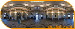
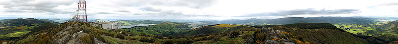
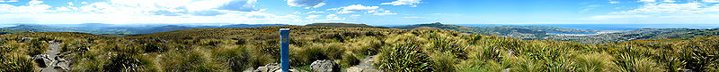
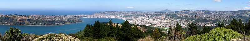
Panoramas
Notable people
Events
Annual events
- January – Whare Flat Folk Festival ends
- January – Southern Festival of Speed classic car road-race
- February – New Zealand Masters Games (Biennial event)
- February – Otago University Students' Association & Otago Polytechnic Orientation Weeks
- February – Dunedin Summer Festival
- March - Fringe Festival
- March – Id Dunedin Fashion Show (to be run in early April in 2010)
- May – Capping week (University of Otago) including the Capping Show run by the Otago University Students' Association
- May – Otago Rally
- May – Regent Theatre 24-hour book sale (reputedly the southern hemisphere's largest regularly-held second-hand book sale)[45]
- July – New Zealand International Science Festival (every second year)
- July – Taste Otago Dunedin Food and Wine Festival
- July – Cadbury Chocolate Carnival
- July- Dunedin International Film Festival
- August/September The German play at Otago University
- August/September - [Undie 500]
- October – Otago Festival of the Arts – every second year (even numbered years)
- October – Rhododendron Week
- December - Samstock Music Festival
- December – Santa Parade
- December – Whare Flat Folk Festival begins
- December – New Year's Eve Party Octagon
Past events
- 1865 – New Zealand Exhibition (1865)
- 1889 – New Zealand and South Seas Exhibition (1889)
- 1898 – Otago Jubilee Industrial Exhibition (1898)
- 1925 – New Zealand and South Seas International Exhibition (1925)
Notable buildings and landmarks
- Dunedin Railway Station
- Dunedin Town Hall
- Larnach Castle
- Cargill's Castle
- Cadbury World
- Olveston
- Speight's Brewery
- University of Otago Registry Building
- University of Otago Clocktower complex
- Regent Theatre
- Fortune Theatre
- Municipal Chambers
- Allied Press Building
- Dunedin Public Hospital
- Meridian Mall
- The Octagon
Museums, art galleries, and libraries
- Otago Museum
- Otago Settlers Museum
- Dunedin Public Art Gallery
- Dunedin Public Libraries
- Hocken Library
Churches
- All Saints Church, Dunedin
- St. Paul's Cathedral
- First Church
- Knox Church
- St. Joseph's Cathedral
- Kaikorai Presbyterian Church
- Church of Jesus Christ of Latter-day Saints
- Hanover Street Baptist Church — now the Monkey Bar
- Trinity Wesleyan Church — now the Fortune Theatre
Parks and gardens
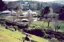
- Botanical Gardens
- Dunedin Chinese Garden
Places of education
Tertiary
- University of Otago
- Otago Polytechnic
- Aoraki Polytechnic (Dunedin campus)
- Dunedin College of Education
Secondary
- Bayfield High School
- Otago Boys' High School
- Otago Girls' High School
- Columba College
- St. Hilda's Collegiate School
- John McGlashan College
- Kavanagh College
- Logan Park High School
- Kaikorai Valley College
- King's High School
- Queen's High School
- Taieri College
Sport
Major teams
- The Highlanders – Super 14 rugby team (represents Otago & Southland provinces)
- Otago Rugby Football Union – Air New Zealand Cup rugby
- Otago Volts and Otago Sparks – men's and women's cricket teams
- Southern Steel – ANZ Championship netball team (represents Otago & Southland Netball- Based in Invercargill)
- Otago United – football (soccer) team in the New Zealand Football Championship
- Otago Nuggets – National Basketball League basketball team (Now defunct)
- Dunedin Thunder- New Zealand Ice Hockey League Ice Hockey Team
- Caversham AFC- Soccersouth Premier League
Major grounds and stadia
- Caledonian Ground
- Carisbrook Notable for being the southernmost venue on the planet that hosts Test Cricket
- Dunedin Ice Stadium
- The Edgar Centre
- Forbury Park Raceway
- Forsyth Barr Stadium at University Plaza (currently under construction)
- Logan Park
- Moana Pool
- Tonga Park
- University Oval
International relations
Twin towns – Sister cities
Dunedin is twinned with several cities throughout the world. These include:
|
Further reading
- Herd, J. & Griffiths, G. J. (1980). Discovering Dunedin. Dunedin: John McIndoe. ISBN 0-86868-030-3.
- Smallfield, J. & Heenan, B. (2006) Above the belt: A history of the suburb of Maori Hill. Dunedin: Maori Hill History Charitable Trust. ISBN 1-877139-98-X.
References
Bibliography
- Anderson, Atholl (1983), When All the Moa-Ovens Grew Cold : nine centuries of changing fortune for the southern Maori, Dunedin, NZ: Otago Heritage Books
- Anderson, Atholl (1998), The Welcome of Strangers : an ethnohistory of southern Maori A.D. 1650–1850, Dunedin, NZ: University of Otago Press with Dunedin City Council, ISBN 1-877133-41-8 pb
- Anderson, Atholl; Allingham, Brian; Smith, Ian W G (1996), Shag River Mouth : the archaeology of an early southern Maori village, Canberra, Australia: Australian National University, ISBN 0-7315-0342-1, OCLC 34751263
- Bathgate, Alexander (ed) (1890), Picturesque Dunedin, Dunedin, NZ: Mills, Dick & Co., OCLC 154535977
- Beaglehole, J C (ed) (1955–67), The Journals of Captain James Cook, London, UK: The Hakluyt Society
- Begg, A Charles; Begg, Neil Colquhoun (1979), The world of John Boultbee : including an account of sealing in Australia and New Zealand, Christchurch, NZ: Whitcoulls, ISBN 0723306044
- Bishop, Graham; Hamel, Antony (1993), From sea to silver peaks, Dunedin: John McIndoe, ISBN 0-86868-149-0
- Collins, Roger; Entwisle, Peter (1986), Pavilioned in Splendour, George O'Brien's Vision of Colonial New Zealand, Dunedin, NZ: Dunedin Public Art Gallery, ISBN ISBN 0-9597758-1-1
- Dann, Christine; Peat, Neville (1989), Dunedin, North and South Otago, Wellington: GP Books, ISBN 0-477-01438-0
- Dunn, Michael (2005), Nerli an Italian Painter in the South Pacific, Auckland University Press., ISBN 1-86940-335-5
- Entwisle, Peter (1984), William Mathew Hodgkins & his Circle, Dunedin, NZ: Dunedin Public Art Gallery, ISBN 0-473-00263-0
- Entwisle, Peter (1998), Behold the Moon, the European Occupation of the Dunedin District 1770–1848, Dunedin, NZ: Port Daniel Press., ISBN 0-473-05591-0
- Entwisle, Peter (2005), Taka, a Vignette Life of William Tucker 1784–1817, Dunedin, NZ: Port Daniel Press., ISBN 0-473-10098-3
- Entwisle, Peter; Dunn, Michael; Collins, Roger (1988), Nerli An Exhibition of Paintings & Drawings, Dunedin, NZ: Dunedin Public Art Gallery, ISBN 0-9597758-4-6
- Hamel, J (2001), The Archaeology of Otago, Wellington, NZ: Department of Conservation, ISBN 0-478-22016-2
- Hayward, Paul (1998), Intriguing Dunedin Street Walks, Dunedin, NZ: Express Office Services
- Hocken, Thomas Moreland (1898), Contributions to the Early History of New Zealand (Settlement of Otago), London, UK: Sampson Low, Marston and Company, OCLC 3804372
- McCormick, E H (1954), The Expatriate, a Study of Frances Hodgkins, Wellington, NZ: New Zealand University Press., OCLC 6276263
- McCormick, E H (1959), The Inland Eye, a Sketch in Visual Autobiography, Auckland, NZ: Auckland Gallery Associates, OCLC 11777388
- McDonald, K C (1965), City of Dunedin, a Century of Civic Enterprise, Dunedin, NZ: Dunedin City Corporation, OCLC 10563910
- McLintock, A H (1949), The History of Otago; the origins and growth of a Wakefield class settlement, Dunedin, NZ: Otago Centennial Historical Publications, OCLC 154645934
- McLintock, A H (1951), The Port of Otago, Dunedin, NZ: Otago Harbour Board
- Morrell, W P (1969), The University of Otago, a Centennial History, Dunedin, NZ: University of Otago Press., OCLC 71676
Notes
- ↑ [1]
- ↑ "Supersport's Good Week / Bad Week: An unhappy spectator". The New Zealand Herald. 1 May 2009. http://www.nzherald.co.nz/sport/news/article.cfm?c_id=4&objectid=10569715. Retrieved 2009-09-18.
- ↑ 3.0 3.1 Irwin, Geoff; Walrond, Carl (2009-03-04). "When was New Zealand first settled? - The date debate". Te Ara Encyclopedia of New Zealand. http://www.teara.govt.nz/en/when-was-new-zealand-first-settled/1. Retrieved 2010-02-14.
- ↑ Dunedin Town Board
- ↑ "Mayor Peter Chin". Dunedin City Council. http://www.dunedin.govt.nz/your-council/councillors/mayor-peter-chin. Retrieved 2008-09-06.
- ↑ "Subnational population estimates at 30 June 2010 (boundaries at 1 November 2010)". Statistics New Zealand. 26 October 2010. http://www.stats.govt.nz/~/media/Statistics/Methods%20and%20Services/Tables/Subnational%20population%20estimates/subnational-pop-estimate-jun2001-2010.ashx. Retrieved 26 October 2010.
- ↑ (Hamel 2001); (Anderson, Allingham & Smith 1996); (Anderson 1998)
- ↑ (Anderson 1983)
- ↑ (Anderson, Allingham & Smith 1996) & (Hamel 2001)
- ↑ (Anderson 1998)
- ↑ Turton, Hanson "Introductory"in (Bathgate 1890); (Entwisle 2005)
- ↑ 12.0 12.1 (McLintock 1949)
- ↑ (Anderson 1983) & (Anderson 1998)
- ↑ Boultbee, J in (Begg & Begg 1979)
- ↑ Cook, James in (Beaglehole (ed) 1955–67)
- ↑ (Entwisle 2005)
- ↑ (Entwisle 1998)
- ↑ Byrne, T. B.. "Wing, Thomas 1810–1888". Dictionary of New Zealand Biography. http://www.dnzb.govt.nz/DNZB/alt_essayBody.asp?essayID=1W33. Retrieved 2009-03-17.
- ↑ Somerville, Ross. "Tuckett, Frederick 1807? – 1876". Dictionary of New Zealand Biography. http://www.dnzb.govt.nz/DNZB/alt_essayBody.asp?essayID=1T108. Retrieved 2009-03-17.
- ↑ (Hocken 1898)
- ↑ (McLintock 1949); (McDonald 1965)
- ↑ Betteridge, Chris (28 July 2004). "Landscapes of Memory – breathing new life into old cemeteries" (PDF). NZ Historic Places Trust. p. 2. http://www.historic.org.nz/aboutus/OtagoBranch/gfx/Lawson%20Lecture%202004.pdf. Retrieved 2008-05-14.
- ↑ (Morrell 1969)
- ↑ (McLintock 1951)
- ↑ (McLintock 1949); (McDonald 1965); (Entwisle 1984)
- ↑ (Entwisle 1984)
- ↑ (Collins & Entwisle 1986)
- ↑ (McCormick 1954); (Entwisle 1984); (Entwisle, Dunn & Collins 1988); (Dunn 2005)
- ↑ (McCormick 1959)
- ↑ Roy Shuker Understanding popular music Routledge, 2001
- ↑ Dunedin City council page
- ↑ Thread fashion magazine article
- ↑ Schaer, Cathrin (2008-03-03). "Rain fails to dampen Dunedin's fashion parade". New Zealand Herald (APN Holdings). http://www.nzherald.co.nz/category/story.cfm?c_id=151&objectid=10495751.
- ↑ "Steepest Streets in Dunedin". Dunedin City Council. http://www.cityofdunedin.com/city/?page=roading_steep_street. Retrieved 2008-05-16.
- ↑ 35.0 35.1 35.2 35.3 (Dann & Peat 1989)
- ↑ (Bishop & Hamel 1993)
- ↑ Lambert, M. (ed.) (1988) Air New Zealand almanac. Wellington, NZ: New Zealand Press Association, p. 394-5. Long-term average, 1951–1980.
- ↑ A Descriptive Atlas of New Zealand, A.H. McLintock (ed), New Zealand Government Printer, 1959 (see Map 8)
- ↑ "CliFlo data Musselburgh (5402, 15752)". NIWA. http://cliflo.niwa.co.nz/. Retrieved 2007-10-15.
- ↑ 40.0 40.1 40.2 40.3 40.4 Quickstats about Dunedin City
- ↑ Community archive. Retrieved 2 November 2009.
- ↑ Otago Ferries Inc. Retrieved 2 November 2009.
- ↑ Hayward 1998, p.65
- ↑ Hayward 1998, p.66
- ↑ "NZ’s biggest book sale reaches 25 year milestone". Scoop. 2005-05-09. http://www.scoop.co.nz/stories/CU0505/S00062.htm. Retrieved 2009-07-25.
- ↑ "Edinburgh – Twin and Partner Cities". © 2008 The City of Edinburgh Council, City Chambers, High Street, Edinburgh, EH1 1YJ Scotland. http://www.edinburgh.gov.uk/internet/city_living/CEC_twin_and_partner_cities. Retrieved 2008-12-21.
External links
- City of Dunedin official website
- Dunedin travel guide from Wikitravel
- LiveDunedin – Art, Culture and Lifestyle events in Dunedin (weekly listing)
- Profiles of relevant websites categorised geographically
- Tourism Dunedin
- Dunedin Directory and Information website
- Dunedin Street Map
|
|||||||||||||||||||||||
|
|||||||||||||||||||
|
||||||||||||||||||||||||||||||||