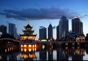
Guiyang
| Guiyang 贵阳 |
|
|---|---|
| — Prefecture-level city — | |
| 贵阳市 | |
 |
|
.png) |
|
 Guiyang
|
|
| Coordinates: | |
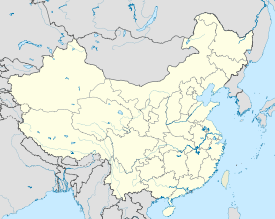
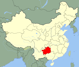
| Country | China |
| Province | Guizhou |
| Area | |
| - Total | 8,034 km2 (3,101.9 sq mi) |
| Population (2008) | |
| - Total | 3,930,000 |
| - Density | 489.2/km2 (1,266.9/sq mi) |
| Time zone | China Standard (UTC+8) |
| Postal code | 550000 |
| Area code(s) | +86-851 |
| Website | http://www.gygov.gov.cn/ |
| Guiyang | |||||||||||||||
|---|---|---|---|---|---|---|---|---|---|---|---|---|---|---|---|
| Simplified Chinese | 贵阳 | ||||||||||||||
| Traditional Chinese | 貴陽 | ||||||||||||||
| Hanyu Pinyin | Guìyáng | ||||||||||||||
| Literal meaning | valuable light | ||||||||||||||
|
|||||||||||||||
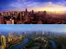
Guiyang (simplified Chinese: 贵阳; traditional Chinese: 貴陽; pinyin: Guìyáng) is the capital of Guizhou Province, the People's Republic of China.
Guiyang is located in central Guizhou province, situated on the east of the Yungui Plateau, and on the north bank of the Nanming River, a branch of the Wu River. The city has an elevation of about 1,100 meters. It has an area of 8,034 square kilometers.[1]
Contents |
History
The city was first constructed as early as 1283 AD during the Yuan Dynasty. It was originally called Shunyuan (順元), meaning obeying the Yuan (the Mongol rulers).
Originally the area was populated by non-Chinese. The Sui dynasty (AD 581–618) had a commandery there, and the Tang dynasty (618–907) a prefecture. They were, however, no more than military outposts, and it was not until the Yuan (Mongol) invasion of southwest China in 1279 that the area was made the seat of an army and a "pacification office." Chinese settlement in the area also began at that time, and, under the Ming (1368–1644) and Qing (1644–1911) dynasties, the town became the seat of a superior prefecture named Guiyang.
Locally Guiyang was an important administrative and commercial center with two distinct merchant communities, consisting of the Sichuanese, who lived in the "new" northern part of the city, and those from Hunan, Guangdong, and Guangxi province, who lived in the "old" southern part. Nevertheless, until the Sino-Japanese War (1937–45), Guiyang was no more than the capital of one of China's least-developed provinces. As elsewhere in the southwest, considerable economic progress was made under the special circumstances of wartime. Road transport infrastructure with Kunming in Yunnan province and with Chongqing in Sichuan (China's wartime provisional capital) and into Hunan were established. Work was begun on a railway from Liuzhou in Guangxi, and after 1949 this development was accelerated. Guiyang has subsequently become a major provincial city and industrial base. In 1959 the rail network in Guangxi was completed, allowing seamless connection from Guizhou to Chongqing to the north, to Kunming to the west, and Changsha to the east.
Geography
{{ Subst:Weather box maker chart | Guiyang | 2.7 | 8.8 | 21 | 4.0 | 10.8 | 20 | 7.8 | 16.1 | 33 | 12.7 | 21.2 | 88 | 16.3 | 24.1 | 165 | 19.1 | 26.4 | 225 | 20.7 | 28.3 | 177 | 20.2 | 28.5 | 127 | 17.4 | 25.1 | 100 | 13.3 | 20.5 | 98 | 9.0 | 15.9 | 47 | 4.7 | 11.6 | 18 |source = CMA |float=left |clear=both }}
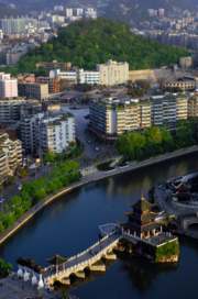
Guiyang has grown exponentially since the 1990s. The city's heart is around the 大十字 (literally "Big Ten") which is a cross, resembling the Chinese character for ten, and 喷水池 (literally "Fountain Pool") which is a traffic intersection which had a large fountain at its center, until the fountain was paved over in early 2010 to help improve the flow of traffic.
The city is situated on the Nanming River, a headstream of the Wu River, which eventually joins the Yangtze River at Fuling in Sichuan province. Guiyang is a natural transportation center, with comparatively easy access northward to Sichuan, eastward to Guangxi and Guangdong, westward to Yunnan, and northeast to Hunan province.
The total area of land is 804,667 ha., including cultivated land of 288,979 ha., accounting for 35.91%; garden land of 5616 ha., accounting for 0.70%; forest land of 266,258 ha., accounting for 33.09% (15.97% of forest coverage); grazing land of 28,860 ha., accounting for 3.59%; water surface area (including residential area, industrial land, traffic land and water conservancy facilities) of 48276 ha., accounting for 6.00%; unused land of 15143 ha., accounting for 18.82%.
The land area per capita is 0.26 ha. and the cultivated land area per capita is 0.093 ha. As for agricultural population, the land area per capita is 0.46 ha., less than a half of the national average and the cultivated land per capita is 0.17 ha., being one-third of the national average.Unused land in Guiyang is 151431 ha. in which there are 35348 ha. wasteland, 72191 ha. exposed conglomerate, 4301 ha. field ridge, 334 ha. exposed land and 236 ha. mudflat.The kind of soil in Guiyang covers 8 classifications, that is, yellow soil, brown soil, calcareous soil, purple soil, moist soil, bog soil, rice soil and meadow soil, in which there are 301600 ha. yellow soil, 196600 ha. calcareous soil and 80100 ha. rice soil, accounting for 49059%, 32.33% and 13.17% respectively.
Climate
Guiyang has a four-season, humid subtropical climate (Koppen Cwa), tempered by its low latitude and high elevation. It has fairly mild winters, warm summers and a monsoon season, where the majority of the year's 1,118 mm (44.0 in) of precipitation falls. The mean temperature in January is 5.8 °C (42.4 °F) and for July 24.5 °C (76.1 °F). Rain falls throughout the year, with occasional flurries in winter. At only 1150 hours of sunshine, it is also one of China's least sunny cities. Relative humidity is consistent throughout the year.
In the year of 2000, Guiyang had an average temperature of 13.9℃, lower than normal; the rainfall of 1424.5 mm, higher than normal; the sunshine time of 1124.5 hours, less 161 hours than usual years. The climates in all seasons are as follows: in the winter, dry and warm in early days, as well as cold, excessive rain and freezing snow in middle and later days; in the spring, lower average temperature, normal rainfall, excessive rain; in the summer, lower average temperature, excessive and well-distributed rainfall, no excessive rainstorm; in the autumn, lower average temperature, lower rainfall, usual sunshine time equally with the average value.
| Climate data for Guiyang(1971-2000) | |||||||||||||
|---|---|---|---|---|---|---|---|---|---|---|---|---|---|
| Month | Jan | Feb | Mar | Apr | May | Jun | Jul | Aug | Sep | Oct | Nov | Dec | Year |
| Average high °C (°F) | 8.8 (47.8) |
10.8 (51.4) |
16.1 (61) |
21.2 (70.2) |
24.1 (75.4) |
26.4 (79.5) |
28.3 (82.9) |
28.5 (83.3) |
25.1 (77.2) |
20.5 (68.9) |
15.9 (60.6) |
11.6 (52.9) |
19.8 (67.6) |
| Average low °C (°F) | 2.7 (36.9) |
4.0 (39.2) |
7.8 (46) |
12.7 (54.9) |
16.3 (61.3) |
19.1 (66.4) |
20.7 (69.3) |
20.2 (68.4) |
17.4 (63.3) |
13.3 (55.9) |
9.0 (48.2) |
4.7 (40.5) |
12.3 (54.1) |
| Precipitation mm (inches) | 20.5 (0.807) |
20.1 (0.791) |
32.8 (1.291) |
87.6 (3.449) |
164.6 (6.48) |
225.2 (8.866) |
177.0 (6.969) |
126.8 (4.992) |
100.1 (3.941) |
97.5 (3.839) |
47.4 (1.866) |
18.1 (0.713) |
1,117.7 (44.004) |
| Avg. precipitation days (≥ 0.1 mm) | 13.7 | 12.8 | 13.3 | 15.6 | 18.4 | 16.7 | 15.3 | 14.1 | 13.0 | 14.4 | 12.1 | 10.3 | 169.7 |
| Sunshine hours | 41.2 | 47.1 | 81.8 | 103.5 | 108.4 | 104.2 | 154.4 | 167.1 | 119.4 | 91.4 | 69.0 | 62.4 | 1,149.9 |
| Source: 中国气象局 国家气象信息中心 | |||||||||||||
Administrative divisions
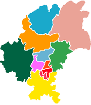
- Wudang District (乌当区)
- Nanming District (南明区)
- Yunyan District (云岩区)
- Huaxi District (花溪区)
- Baiyun District (白云区)
- Xiaohe District (小河区)
- Qingzhen City (清镇市)
- Kaiyang County (开阳县)
- Xiuwen County (修文县)
- Xifeng County (息烽县)
- Jinyang New District (金阳新区)
Economy
Guiyang is the economic and commercial hub of Guizhou Province. The GDP per capita was ¥19,564 (US$2,817) in 2008, ranked no. 206 among 659 Chinese cities. The city is also a large center for retail and wholesale commercial activities with operations of major domestic and international general retailers such as Wal-Mart, Carrefour, RT-Mart, Beijing Hualian, Parksons, and Xingli Group as well as consumer electronics and appliance sellers Gome and Suning. Wholesale operations include large regional produce, furniture, and industrial and construction machinery depots. Wal-Mart's southwest China regional vegetable and produce distribution center is located in Guiyang.
Hydro-electric power generators are located along the city's main rivers including the Wu River. By 2007, the city's hydro electric plants supplied over 70% of the city's electricity. Coal is mined in the locality of Guiyang and Anshun, and there are large thermal generating plants at Guiyang and Duyun, supplying electricity for a portion of the city's industry. A large iron and steel plant came into production in Guiyang in 1960, supplying the local machinery-manufacturing industry.
Large deposits of bauxite have been discovered to the north, and by the 1970s Guiyang had become a major producer of aluminum. Guiyang also manufactures aerospace engine parts and equipment, industrial and mining equipment, as well as railway vehicles and equipment. It has a large chemical industry, producing fertilizers, and a rubber industry, manufacturing automobile tires. Guiyang also has a sizable domestic pharmaceuticals industry, producing traditional Chinese medicines as well as western medicines, textile plants, and makes glass, paper, and other consumer goods.
Demographics
Guiyang is populated by 23 different minorities, the most populous of which is the Miao people, in addition to the ethnic Han.
As of 2008 , the total population of Guiyang municipality was 3.93 million, among which 2.72 million were urban residents.
Transport
- Transportation in Guiyang consists of an extensive network of roads, railways, river and air transport as well as public transportation system with bus system and many taxis. In 2012 the city will also add a city-wide light rail network with 4 rail lines.
- The relatively recently constructed Longdongbao international airport conducts air traffic. *The main southern railway station is being rebuilt in 2008.
- There are four high-speed rail lines to and from Chengdu, Sichuan, Chongqing, Guangzhou, Guandong, Kunming, Yunnan, and Shanghai that will commence operations in 2012. The high speed railway lines will provide rapid freight service from two marshalling yards, and passenger service from a new hi-speed railway station in the city's Jinyang New District as well as from the city's existing Central Railway station.
- The city is located at the junction of four major segments of the national highway grid: the Gui-Huang, Gui-Zun, Gui-Bi, and Gui-Xin Expressways.
- The Gui-Huang Expressway (G60) links Guiyang with the cities and tourist areas of central and western Guizhou including Anshun, Guanling,and the Huangguoshu Waterfall. The expressway continues west to Yunnan Province as the Gui-Kun Expressway and terminates at Yunnan's capital city of Kunming.
- The Gui-Zun Expressway (G75) begins in Guiyang and runs north 180 km to the regional Guizhou city of Zunyi and is the most heavily travelled major highway in Guiyang. In Zunyi, the expressway becomes the Zunyi-Chongqing Expressway and runs a further 210 km north to its terminus in Chongqing.
- The Gui-Bi Expressway (G76) links Guiyang with the regional cities of Bijie and Dafang in northwest Guizhou Province, southeastern Sichuan Province, and the Sichuan cities of Luzhou, Neijiang, and Chengdu - Sichuan's provincial capital. The Gui-Bi Expresway begins at an interchange with the Gui-Zun Expressway in the city's Xiuwen County approximately 20 km north of the city center, before terminating at the city of Bijie. In the city of Dafang, approximately 40 km east of Bijie, the Gui-Bi Expressway connects with the new Sichuan-Guizhou Expressway, a modern highway providing access to Luzhou and central Sichuan.
- The Gui-Xin Expressway begins at the junction of the Guiyang Outer Ring Road (G75-G60.01) and the Tang Ba Guan Road, approximately 5 km southeast of the city center. The Gui-Xin Expressway (G60-G75) runs east and southeast through the Guangxi Zhuang Autonomous Region (G76) and its capital city of Guilin before entering Guangdong Province and terminating at the city of Guangzhou.
- Approximately 170 km east of Guiyang in the regional city of Kaili, the Hunan-Guizhou Expressway (G56-G60) links with the Gui-Xin Expressway providing high-speed vehicular access to and from Guiyang to the eastern Guizhou city of Tongren before continuing through Hunan Province to the major cities of Huaihua, Changde, and Changsha.
- In 2009 Guiyang added a modern orbital expressway to its highway network. The Guiyang Outer Ring Road (Guiyang Orbital Highway) opened in December 2009 and is a six to eight lane divided high-speed expressway that provides efficient links to and from large employment centers in the Jinyang New District, Baiyun District, Huaxi District, the Guiyang Longdongbao International Airport, the major multi-lane national highways, and the city's main roadways, allowing vehicular traffic to circumnavigate the heavy traffic of the city's inner city areas.
- China National Highway 210
Education
The city is the cultural and educational center of Guizhou province and has a university, a teacher-training college, and a medical school.
- Guizhou University
- Guizhou Normal University
- Guiyang Medical University
- Guizhou University of Finance and Economics
- Guizhou Nationalities University
- Guiyang University
- Commercial College of Guizhou
- Institute Of Geochemistry, Chinese Academy of Sciences
- Guiyang College of Traditional Chinese Medicine
Religion
On October 15, 1696, the city was made the seat of the Roman Catholic Apostolic Vicariate of Kweichow. This was suppressed in 1715 and restored in 1846. In 1924 it was renamed as the Apostolic Vicariate of Guiyang, and in 1946 it was promoted to its current status as the Roman Catholic Archdiocese of Guiyang.
International relations
Twin towns — Sister cities
Guiyang is twinned with:
References
- ↑ "Profile of Guiyang" (in Chinese). http://www.xzqh.org/QUHUA/52gz/01guiyang.htm. Retrieved 2008-06-11.
External links
|
|||||||||||||||
|
||||||||||||||||||||||
|
|||||||