Hohhot
| Hohhot 呼和浩特 Kökeqota |
|
|---|---|
| — Prefecture-level city — | |
| City of Hohhot · 呼和浩特市 | |
 |
|
 |
|
| Coordinates: | |
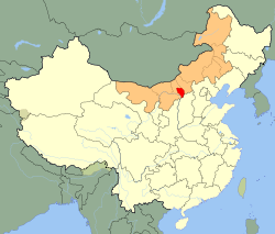
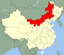
| Country | China |
| Region | Inner Mongolia |
| County-level divisions | 10 |
| Township divisions | 116 |
| Established | 1580 |
| Government | |
| - CPC Committee Secretary | Han Zhiran (韩志然) |
| - Mayor | Tang Aijun (汤爱军) |
| Area | |
| - Prefecture-level city | 17,000 km2 (6,563.7 sq mi) |
| - Urban | 149 km2 (57.5 sq mi) |
| Elevation | 1,065 m (3,494 ft) |
| Population (2004) | |
| - Prefecture-level city | 2,580,000 |
| - Density | 151.8/km2 (393.1/sq mi) |
| - Urban | 1,520,000 |
| - Urban density | 10,201.3/km2 (26,421.4/sq mi) |
| Time zone | China Standard Time (UTC+8) |
| Postal code | 010000 |
| Area code(s) | 471 |
| License plate prefixes | 蒙A |
| GDP (2008) | CNY 131.6 billion |
| - per capita | CNY 51,016 |
| Local Dialect | Jin: Hohhot dialect |
| Website | http://www.huhhot.gov.cn |
| Hohhot | |||||||||||
|---|---|---|---|---|---|---|---|---|---|---|---|
| Chinese | 呼和浩特 | ||||||||||
| Literal meaning | blue city or calling for peace, abundant, & unique | ||||||||||
|
|||||||||||
Hohhot (Mongolian: ![]() , Chinese: 呼和浩特; pinyin: Hūhéhàotè, abbreviated Hū Shì (Chinese: 呼市); also romanized as Huhehot or Huhhot), is a city in north-central China and the capital of the Inner Mongolian Autonomous Region, serving as the region's administrative, economic, and cultural centre.
, Chinese: 呼和浩特; pinyin: Hūhéhàotè, abbreviated Hū Shì (Chinese: 呼市); also romanized as Huhehot or Huhhot), is a city in north-central China and the capital of the Inner Mongolian Autonomous Region, serving as the region's administrative, economic, and cultural centre.
The city was founded by Mongol ruler Altan Khan in the late 16th century. It was chosen as the region's administrative centre in 1952, replacing Ulanhot. A city with a rich cultural background, Hohhot is known for its historical sites and temples and is one of the major tourist destinations of Inner Mongolia. It is also nationally known as the home of China's dairy giants Mengniu and Yili, and was declared "Dairy Capital of China" by the China Dairy Industry Association and the Dairy Association of China in 2005.
The name of the city in Mongolian means "Blue City." The color blue in Mongolian culture is associated with the sky, eternity and purity; in Chinese, the name can be translated as Qīng Chéng (Chinese: 青城), literally, "Blue/Green City."[1]
Contents |
History
Hohhot was founded by Altan Khan around 1580. Altan Khan and his successors constructed temples and fortress in 1579, 1602 and 1727. The Tumed Mongols had long been semiagricultural there. Hui merchants gathered north of the gate of the city's fortress, building a mosque in 1693. Their descendants forms the nucleus of the modern Hui people's district.
The Qing Dynasty built strong garrison town near Hohhot, supervising southwestern Inner Mongolia in 1735-39. In 1913, the government of the new Republic of China united the garrison town and Hohhot as Guisi. With the occupation of the Japanese Empire in 1937, the city was renamed Hohhot. After the World War II, Prince Demchugdongrub's autonomous government in Hohhot surrendered to the Republic of China.
Until 1954, Hohhot was referred to in Chinese as Guisui (歸綏 pinying: Guīsuī, Wade-Giles: Kweisui), which is the abbreviation of the two districts of the city:
- Guihua (歸化, arch. Kwei-hwa): Southeastern old section, business district, established by Altan Khan around 1580.
- Suiyuan (綏遠): Northeastern "New Town", government district. Established in the 17th century by the Manchus.
The two sections later became Guihua District (歸化縣) of the Qing Empire, renamed to Guisui County (歸綏縣) in 1913, and upgraded to a city in 1950. It was the capital of the now-defunct Suiyuan Province. In 1952, under Inner Mongolian chairman Ulanhu, the city became the capital of Inner Mongolia. Suiyuan was annexed to the Inner Mongolian autonomous region two years later.
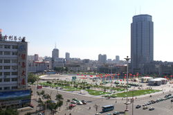
The city has seen significant development since China's reform and opening began. The city's far east side began development around 2000 and is now home to an artificial lake called Ruyi He, a large number of condominiums, the municipal government, and most of the Autonomous Region's government buildings. The Hohhot City Stadium was built on the city's north side.
Subdivisions
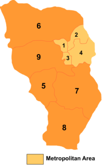
The city is administratively at the prefecture-level, meaning that it administers both its urban area and the rural regions in its vicinity. The administrative area includes 4 counties, 4 districts, and a county-level banner; they are further divided into 20 urban sub-districts, and 96 townships.
| Map | # | Name | Hanzi | Hanyu Pinyin | Population (2004 est.) | Area (km²) | Density (/km²) |
|---|---|---|---|---|---|---|---|
 |
|||||||
| 1 | Huimin District | 回民区 | Huímín Qū | 220,000 | 175 | 1,257 | |
| 2 | Xincheng District | 新城区 | Xīnchéng Qū | 320,000 | 700 | 457 | |
| 3 | Yuquan District | 玉泉区 | Yùquán Qū | 190,000 | 213 | 892 | |
| 4 | Saihan District | 赛罕区 | Sàihǎn Qū | 360,000 | 1,013 | 355 | |
| 5 | Togtoh County | 托克托县 | Tuōkètuō Xiàn | 200,000 | 1,313 | 152 | |
| 6 | Wuchuan County | 武川县 | Wǔchuān Xiàn | 170,000 | 4,885 | 35 | |
| 7 | Horinger County | 和林格尔县 | Hélíngé'ěr Xiàn | 190,000 | 3,401 | 56 | |
| 8 | Qingshuihe County | 清水河县 | Qīngshuǐhé Xiàn | 140,000 | 2,859 | 49 | |
| 9 | Tumed Left Banner | 土默特左旗 | Tǔmòtè Zuǒ Qí | 350,000 | 2,712 | 129 |
Geography and climate
| Hohhot | ||||||||||||||||||||||||||||||||||||||||||||||||||||||||||||
|---|---|---|---|---|---|---|---|---|---|---|---|---|---|---|---|---|---|---|---|---|---|---|---|---|---|---|---|---|---|---|---|---|---|---|---|---|---|---|---|---|---|---|---|---|---|---|---|---|---|---|---|---|---|---|---|---|---|---|---|---|
| Climate chart () | ||||||||||||||||||||||||||||||||||||||||||||||||||||||||||||
|
||||||||||||||||||||||||||||||||||||||||||||||||||||||||||||
|
||||||||||||||||||||||||||||||||||||||||||||||||||||||||||||
Located in the south central part of Inner Mongolia, Hohhot is encircled by the Daqing Shan (大青山, lit. Great blue Mountains) to the north and the Hetao Plateau to the south. Hohhot features a cold semi-arid climate (Koppen BSk), marked by long and very cold winters, very warm summers, and strong winds, especially in spring: the January average is −10.9 °C (12 °F), while the July average is 22.5 °C (72.5 °F). Winter temperatures have been as low as −30.5 °C (−23 °F) and summer temperatures as high as 38.5 °C (101 °F).[2] The annual precipitation is app. 400 millimetres (15.7 in), with nearly two-thirds of it falling from June to August. Hohhot is a popular destination for tourists during the summer months because of the nearby Zhaohe grasslands. More recently, due to desertification, the city sees sandstorms on almost an annual basis.
| Climate data for Hohhot (1971-2000) | |||||||||||||
|---|---|---|---|---|---|---|---|---|---|---|---|---|---|
| Month | Jan | Feb | Mar | Apr | May | Jun | Jul | Aug | Sep | Oct | Nov | Dec | Year |
| Average high °C (°F) | −5.0 (23) |
−0.4 (31.3) |
7.0 (44.6) |
16.3 (61.3) |
23.2 (73.8) |
27.3 (81.1) |
28.5 (83.3) |
26.4 (79.5) |
21.2 (70.2) |
14.1 (57.4) |
4.4 (39.9) |
−3.2 (26.2) |
13.3 (55.9) |
| Average low °C (°F) | −16.8 (1.8) |
−12.8 (9) |
−5.5 (22.1) |
1.6 (34.9) |
8.2 (46.8) |
13.3 (55.9) |
16.4 (61.5) |
14.8 (58.6) |
8.3 (46.9) |
1.0 (33.8) |
−7.0 (19) |
−14.2 (6.4) |
0.6 (33.1) |
| Precipitation mm (inches) | 2.6 (0.102) |
5.2 (0.205) |
10.2 (0.402) |
13.5 (0.531) |
27.6 (1.087) |
47.2 (1.858) |
106.5 (4.193) |
109.1 (4.295) |
47.4 (1.866) |
20.7 (0.815) |
6.2 (0.244) |
1.8 (0.071) |
397.9 (15.665) |
| Avg. precipitation days (≥ 0.1 mm) | 2.5 | 2.8 | 3.4 | 3.7 | 6.0 | 8.9 | 12.9 | 12.7 | 8.3 | 4.5 | 2.4 | 1.8 | 69.9 |
| Sunshine hours | 180.7 | 198.3 | 245.5 | 268.6 | 294.5 | 291.3 | 264.9 | 255.2 | 252.1 | 244.8 | 195.3 | 171.0 | 2,862.2 |
| Source: China Meteorological Administration [2] | |||||||||||||
Culture and demographics
As of 2005, 87.3% is Han Chinese, 9.6% of the city's registered population is of ethnic Mongol origin, 1.6% is Hui, 1.2% is Manchu, and the rest belong to smaller minorities, including Korean and Uyghur.[3] Most Han in Hohhot are descendants of people from Shanxi who have settled in the area over the past several decades, or those who have migrated from Northeastern China and Hebei province after the founding of the People's Republic of China in 1949, supported by government initiatives at the time to promote the development of border regions. Having been integrated into mainstream urban society, most Mongolians in the city speak fluent standard Mandarin in addition to Mongolian. However, younger speakers are moving towards speaking Mandarin amongst themselves as well. A significant portion of the population is of mixed ethnic origin.[4]
The majority of Hohhot residents can converse fluently in Mandarin, but there exists a linguistic divide between "old-town" folk (comprising today's Huimin District), with a large Muslim Hui minority, who tend to converse in raw Hohhot dialect, a branch of the Jin language from neighboring Shanxi province. This spoken form can be difficult to understand for a standard Mandarin speaker or even Mandarin speakers from the other side of the city. The newer residents, mostly concentrated in Xincheng and Saihan Districts, speak Hohhot-based Mandarin Chinese, the majority also with a noticeable accent and some unique vocabulary. (See Hohhot dialect for further details)
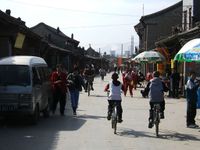
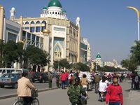
Due to its relatively diverse cultural make-up, and despite its characteristics as a mid-sized Chinese industrial city, the Hohhot street scene has no shortage of ethnic minority elements. Tongdao Road, a major street in the old town area, is decorated with Islamic and Mongol exterior designs on all its buildings. A series of government initiatives in recent years have emphasized Hohhot's identity with ethnic minority groups, especially in increasing Mongolian-themed architecture around the city. All street signs as well as public transportation announcements are regulated to be in both Chinese and Mongolian.
Food specialty in the area is mostly focused on Mongolian cuisine and dairy products. Commercially, Hohhot is known for being the base of nationally renowned dairy giants Yili and Mengniu. The Mongolian drink suutei tsai ("naicha" 奶茶 in Chinese, "milk tea" in English), which has become a typical breakfast selection for anyone living or visiting the city. The city also has rich traditions in the making of hot pot and shaomai. There is also a large selection of Korean and Muslim restaurants, in addition to cuisine from other regions of China.
Transportation
Hohhot lies on the Jingbao Railway from Beijing to Baotou. Trains to Beijing link to destinations to the south and the northeast. The most prominent rail link with Beijing is the overnight K90 train, which has served the Hohhot-Beijing line since the 1980s and is referred to colloquially as the "9-0" by locals. Westbound trains go through Baotou and Lanzhou. There are also rail links to most major Inner Mongolian cities and to Ulaanbaatar.
Hohhot's Baita International Airport (IATA:HET) is about half an hour from the city centre by car. It has direct flights to Beijing, Shanghai, Shenzhen, Chengdu, Wuhan, Hong Kong etc., and to Ulaanbaatar, Mongolia. Long distance buses connect Hohhot to Baotou (via the Hubao Expressway) and to other areas in Inner Mongolia.
The city's public transit system is composed of nearly one hundred bus routes and a large fleet of taxicabs, which are normally green. The bus fare is 1 yuan. The taxi fare begins at 6 yuan.
Hohhot's major north-south thoroughfares are called "Lu" and its east-west thoroughfares are called "Jie". This is roughly equivalent to dividing roads into "street" and "avenue" designation according to direction. The largest interchange is near the site of the city's Drum Tower, after which it is named. Several major streets are named after Inner Mongolian leagues; among these, Hulun Buir, Xilin Gol and Xing'an run north-south, while Ulan Chaab runs east-west.
An expressway built in 1997 links Hohhot with Baotou, then known as the Hubao Expressway. Recently this expressway has been expanded eastwards to Zhangjiakou, and onto Beijing as the Jingbao Expressway, which is part of a larger project to connect Beijing to Urumqi.[5] The city is en route of China National Highway 110, which runs from Yinchuan to Beijing. China National Highway 209 begins in Hohhot and is southbound towards southern China, with its southern terminus in Guangxi. Hohhot is connected to its northern counties through the Huwu Highway, which was completed in 2006. Previously travel to the northern counties consisted of lengthy navigation through mountainous terrain.
Education
Universities located in Hohhot include:
- Inner Mongolia University
- Inner Mongolia University of Agriculture
- Inner Mongolia Normal University
- Inner Mongolia University of Technology
- Inner Mongolia College of Medicine
- Inner Mongolia College of Finance and Economics
- Hohhot College of Education
- Hohhot College of Police
High Schools located in Hohhot include:
- Hohhot No.2 Middle School
- Affiliated Middle School to Inner Mongolia Normal University
Artifacts
There are over 50 sets of murals in southeastern Hohhot, including a "Horse-tending Image" (牧馬圖). Over 50 pre-modern Buddhist temples and towers.
Landmarks
- Tomb of Wang Zhaojun: Located to about nine kilometers to the south of the center of Hohhot. It is said to be the resting place of Wang Zhaojun, a commoner woman from the Chinese Han Empire who married a Xiongnu king, Chanyu. .
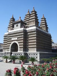
- Temple of the Five Pagodas: Constructed in 1732 with architecture very similar to that of Indian temples. In its walls there are more than 1,500 figures of Buddha.
- Da Zhao Temple: A Buddhist monastery constructed in 1579, the oldest in the city[6].
- Inner Mongolia Museum: Main exhibits include dinosaur fossils, historical artifacts of nomadic peoples, and the cultural life of modern nomadic peoples.
Notes
- ↑ Chinese "qing" has traditionally been a color between "blue" and "green" in English, leading some modern sources to translate Qing Cheng into English as "Green City" instead of "Blue City," including, for example, the official website of Hohhot.
- ↑ 2.0 2.1 2.2 "中国气象科学数据分享服务网". China Meteorological Administration. http://cdc.cma.gov.cn/shuju/index3.jsp?tpcat=SURF&dsid=SURF_CLI_CHN_MUL_MMON_19712000_CES&pageid=3. Retrieved 2009-03-17.
- ↑ Local customs of Hohhot «呼和浩特风情百话», Wei Duo 魏铎, Inner Mongolia People's Press, 2006. In Chinese. ISBN 7-204-07483-1/I 1586
- ↑ Official population data classifies mixed individuals as belonging to a single ethnicity. People with mixed Han and minority origin usually identify themselves legally as belonging to the minority. As a result, minorities may be overrepresented in the statistics.
- ↑ Qianlong
- ↑ 大召寺(Chinese)
External links
- Hohhot government website
- Hohhot travel guide from Wikitravel
|
|||||||||||||||
|
||||||||||||||||||||||
|
|||||||