Malé
|
Malé |
|
|---|---|
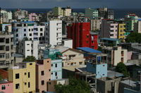
| Malé Island from west,with Hulhule in the background | |
| Island summary | |
| Belongs to | Capital District |
| Location | |
| Area | 5.798 km² |
| Population | 103,693 (2006) |

Malé (Dhivehi: މާލެ), (pronounced: /məːle/) is the capital and most populous city in the Republic of Maldives. It is located at the southern edge of North Malé Atoll (Kaafu Atoll). It is also one of the Administrative divisions of the Maldives. Traditionally it was the King's Island, from where the ancient Maldive Royal dynasties ruled and where the palace was located. The city was also called Mahal. Formerly it was a walled city surrounded by fortifications and gates (doroshi). The Royal Palace (Gan'duvaru) was destroyed along with the picturesque forts (kotte) and bastions (buruzu) when the city was remodelled under President Ibrahim Nasir's rule after the abolition of the monarchy. In recent years, the island has been considerably expanded through landfilling operations.
Contents |
Overview
Although Malé is geographically located in Male, Kaafu Atoll, administratively it is not considered part of it. The central part of the city is formed by Malé Island. Three more islands are part of the city. A commercial harbour is located on Malé Island. It is the heart of all commercial activities in the country.
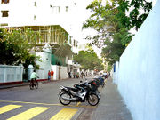
The central island is heavily urbanized, with the built-up area taking up essentially its entire landmass. Slightly less than one third of the nation's population lives in the capital city. Many, if not most, Maldivians and foreign workers in Maldives find themselves in occasional short term residence on the island since it is the only entry point to the nation and the centre of all administration and bureaucracy.
Economy
Maldivian, the airline of the Maldives, has its head office in Malé.[1]
Subdivisions
The city is divided into six divisions, four of which are on Malé Island: Henveiru, Galolhu, Maafannu and Macchangolhi. The nearby island of Vilingili, formerly a tourist resort and prior to that a prison, is the fifth division (Vilimalé). The sixth division is Hulhumalé, an artificial island settled since 2004. In addition, the airport Island Hulhule is part of the city. There are plans for creating a port island on Gulhi Falu reef.[2]
| Nr. | Division | Area (ha) |
Population Census 2006 |
Population Density |
Coordinates | Remarks |
|---|---|---|---|---|---|---|
| 1 | Henveiru | 59.1 | 23,597 | 39,927.2 | Malé Island | |
| 2 | Galolhu | 27.6 | 19,414 | 70,340.6 | ... | Malé Island |
| 3 | Machchangolhi | 32.6 | 19,580 | 60,061.3 | ... | Malé Island |
| 4 | Maafannu | 75.9 | 29,964 | 39,478.3 | ... | Malé Island |
| 1-4 | Malé (Island) | 195.2 | 92,555 | 47,415.5 | Malé Island | |
| 5 | Vilimalé | 31.8 | 6,956 | 21,874.2 | ... | Villingili Island |
| 6 | Hulhumalé | 200.9 | 2,866 | 1,426.6 | ... | artificial island |
| - | Hulhule | 151.9 | 1,316 | 866.4 | ... | airport island |
| - | Gulhi Falhu | - | - | - | ... | planned port island |
| Malé (city) | 579.8 | 103,693 | 17,884.3 |
The Island of Malé is the second most densely populated island worldwide, after Ap Lei Chau of Hong Kong and it is the 168th most populous island in the world. Since there is no surrounding countryside, all infrastructure has to be located in the city itself. Water is provided from desalinated ground water; the water works pumps brackish water from 50-60m deep wells in the city and desalinates that using reverse osmosis.[3] Electric power is generated in the city using diesel generators.[4] Sewage is pumped unprocessed into the sea.[5] Solid waste is transported to nearby islands, where it is used to fill in lagoons. The airport was built in this way, and currently the Thilafushi lagoon is being filled in.[6][7]
Many government buildings and agencies are located on the waterfront. Malé International Airport is on adjacent Hulhule Island which includes a seaplane base for internal transportation. Several land reclamation projects have expanded the harbour.

Etymology
The name Malé is taken from the word महालय "Mahaalay" which has come from the Sanskrit language. The name is derived from मह maha, meaning "big" or "great" and आलय aalay meaning house. Generally the word Mahaalay is used for the palace of a king or capital (king's island) in Sanskrit, e.g. Mahaalay of King Asok.[8] However, the folktale below suggests a different origin of the name.
The whole island group, the Maldives, is named after its capital. The word "Maldives" means "The islands (dives) of Malé'".[9]
Origins of Malé
The first settlers in the Maldive islands were Dravidian people[10] from the nearest shores, which are in the modern Indian Subcontinent and coastal Ceylon. Comparative studies of Maldivian linguistic, oral and other cultural traditions, in addition to folklore, point to a strong Dravidian influence on Maldivian society, centered in Malé, from ancient times. The people of Giraavaru, an island located in Malé Atoll (now a tourist resort, after the forced diaspora of its inhabitants) claim to descend from the first settlers of the Maldives, ancient Tamils.[11]
It is said that Giraavaru fishermen used to go regularly to a certain large sandbank (finolhu) at the southern end of their atoll to clean tuna fish after a good catch. Owing to the large amount of tuna fish offal and blood, the waters around that sandbank looked like a big pool of blood (maa ley gandeh). "Maa" (from the Sanskrit मह "Maha"), meaning big, and "Lē" meaning blood. Traditionally the first inhabitants of the Maldives, which include the Giravaru people, didn't have kings. They lived in a simple society and were ruled by local headmen. But one day a prince from the Subcontinent called Koimala arrived to Malé Atoll sailing from the North on a big ship. The people of Giraavaru spotted his vessel from afar and welcomed him. They allowed Prince Koimala to settle on that large sandbank in the midst of the waters tainted with fish blood. Trees were planted on the sandbank and it is said that the first tree that grew on it was the papaya tree. However this could refer to any tree that bears edible fruit as the archaic Dhivehi word (and Mahal word even today) for fruit was the same as that for the papaya (falhoa)[12]. As time went by the local islanders accepted the rule of this Northern Prince. A palace was built and the island was formally named Maa-le (Malé), while the nearest island was named Hulhu-le.
The names of the main four wards or divisions of Malé Island are said to have been given by the aboriginal Giraavaru fishermen: Maafannu from "maa" (big) and "fannu" (a place where a village path meets the sea), Henveiru from "en-beyru" (out where fishermen got their bait), Galolhu from "galu-olhu" (stone groove) and, Macchangolhi from "mathi-angolhi" (windward path-fork).
See also
- Effect of the 2004 Indian Ocean earthquake on the Maldives
- Hulhumalé
Footnotes
- ↑ Island.com.mv, Maldivian. Retrieved November 23, 2009.
- ↑ Gulhifalhu.com, Global Business Park Gulhi Falhu
- ↑ Malé Water & Sewage Company Pvt Ltd. "Malé Water & Sewage FAQ". http://www.mwsc.com.mv/faqs/faq.shtml. Retrieved 2008-11-12.
- ↑ Stelco. "Stelco Corporate Profile". http://www.stelco.com.mv/about.html. Retrieved 2008-11-12.
- ↑ Malé Water & Sewage Company Pvt Ltd. "Malé Water & Sewage FAQ". http://www.mwsc.com.mv/faqs/faq.shtml#a3. Retrieved 2008-11-12.
- ↑ United Nations Environmental Programme. "Management of Solid Waste and Sewage" (PDF). http://www.rrcap.unep.org/reports/soe/maldives_solid.pdf. Retrieved 2008-11-12.
- ↑ Abdullah Waheed. "Gold in Garbage — the Experience from Maldives" (PDF). http://www.searo.who.int/LinkFiles/Public_Information_&_Events_vol3-1_goldingar.pdf. Retrieved 2008-12-11.
- ↑ Vaman Shivram Apte; Sanskrit English Dictionary
- ↑ Caldwell, Comparative Dravidian Grammar, p. 27-28
- ↑ Xavier Romero-Frias, The Maldive Islanders, A Study of the Popular Culture of an Ancient Ocean Kingdom
- ↑ Maloney, Clarence. "Maldives People". http://www.iias.nl/iiasn/iiasn5/insouasi/maloney.html. Retrieved 2008-06-22.
- ↑ A Concise Ethymological Vocabulary of Dhivehi Language. Hasan A. Maniku. Speedmark. Colombo 2000
References
- H. C. P. Bell, The Maldive Islands, An account of the physical features, History, Inhabitants, Productions and Trade. Colombo 1883, ISBN 81 206 1222 1
- H.C.P. Bell, The Maldive Islands; Monograph on the History, Archaeology and Epigraphy. Reprint Colombo 1940. Council for Linguistic and Historical Research. Male’ 1989
- H.C.P. Bell, Excerpta Maldiviana. Reprint Asian Educational Services. New Delhi 2002
- Xavier Romero-Frias, The Maldive Islanders, A Study of the Popular Culture of an Ancient Ocean Kingdom. Barcelona 1999, ISBN 84 7254 801 5
|
||||||||||||||||||||||||||||
