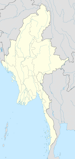
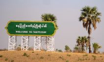
Naypyidaw
| Naypyitaw နေပြည်တော် |
|
|---|---|
| — Capital City — | |
 |
|
 Naypyitaw
|
|
| Coordinates: | |
| Country | Burma |
| Admin. division | Union Territory[1] |
| Subdivisions | 8 townships |
| Settled | 2005 |
| Incorporated | 2008 |
| Government[2] | |
| - Mayor | Colonel Thein Nyunt |
| Area[3] | |
| - Total | 2,723.7 sq mi (7,054.37 km2) |
| Population (2009)[4] | |
| - Total | 925,000 |
| [5] | |
| Time zone | MST (UTC+6:30) |
| Area code(s) | 067 |
Naypyidaw (Burmese: နေပြည်တော်; MLCTS: nepranytau, officially spelled Nay Pyi Taw and Naypyitaw; pronounced [nèpjìdɔ̀]) is the capital of Burma, also known as Myanmar. It is administered as a Union Territory, as per the 2008 Constitution.[1] On 6 November 2005, the administrative capital of Burma was officially moved to a greenfield site 2 miles (3.2 km) west of Pyinmana, and approximately 200 miles (320 km) north of Yangon (Rangoon), the previous capital. The capital's official name was announced on 27 March 2006, Burmese Armed Forces Day. Much of the city is still under construction, which is set to be completed by around 2012.[6] As of 2009, the population was 925,000,[5] which makes it Burma's third largest city, behind Yangon and Mandalay.
Contents |
Etymology
Nay Pyi Daw is generally translated as "royal capital",[7] "seat of the king" or "abode of kings".[3] Traditionally, it was used as a suffix to the names of royal capitals, such as Mandalay, which was called ရတနာပုံနေပြည်တော် (Yadanabon Naypyidaw). The name literally means "royal city of the sun" in Burmese.
History
Naypyidaw has a short history, having been founded on a greenfield site in the scrubland 2 miles (3.2 km) west of Pyinmana, and approximately 200 miles (320 km) north of Yangon, with construction starting in 2002.[3] At least 25 construction companies were hired by the military government to work on the city, including Asia World and Htoo Ltd.[8] The military government began moving government ministries from Yangon to Naypyidaw on 6 November 2005 at the astrologically auspicious time of 6:37 a.m.[9] Five days later, on 11 November at 11 a.m., a second convoy of 1,100 military trucks carrying 11 military battalions and 11 government ministries left Yangon. The ministries were expected to be mostly in place by the end of February 2006; however, the hasty move led to a lack of schools and other amenities which separated the government employees from their families for the time being. The government originally prohibited families of government workers from moving to the new capital.[10] Military headquarters were located in a separate compound from the government ministries, and civilians have been banned from entering either. Vendors are restricted to a commercial zone near the government offices. For official works, officers use "NPT" as a synonym.
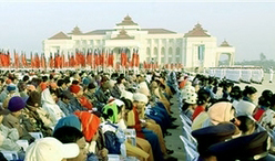
On 27 March 2006, more than 12,000 troops marched in the new capital in its first public event: a massive military parade to mark Armed Forces Day—which is the anniversary of Burma's 1945 uprising against Japanese occupation. Filming was restricted to the concrete parade ground which contains three enormous sculptures—depictions of the Burmese kings Anawrahta, Bayinnaung and Alaungpaya, who are considered the three most important kings in Burmese history. The city was officially named Naypyidaw during these ceremonies.[11]
Rationale for moving the capital
Naypyidaw is more centrally and strategically located than the old capital Yangon. It is also a transportation hub located adjacent to the Shan, Kayah and Karen states. It was felt that a stronger military and governmental presence nearby might provide stability to those chronically turbulent regions.[12] The official explanation for moving the capital was that Yangon had become too congested and crowded with little room for future expansion of government offices.[3]
Some Western diplomats speculated that the government were concerned with the possibility of foreign invasion, as Yangon is on the coast and therefore vulnerable to a seaborne landing.[13][14] Indian journalist Siddharth Varadarajan, who visited Naypyidaw in January 2007, described the vastness of the new capital as "the ultimate insurance against regime change, a masterpiece of urban planning designed to defeat any putative "colour revolution" – not by tanks and water cannons, but by geometry and cartography".[15]
Geography
Naypyidaw is located between the Bago Yoma and Shan Yoma mountain ranges. The city covers an area of 7,054.37 square km and has a population of 924,608, according to official figures.[5]
Chaungmagyi Dam is located a few kilometers to the north of Naypyidaw, while Ngalaik Dam is a few kilometers to the south. The Yezin Dam is further away, to the northeast.
Cityscape
Naypyidaw is organized into a number of zones. The city is still lacking many of the facilities one would expect in a capital city.
Residential zones
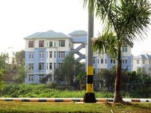
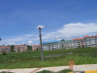
The residential areas are carefully organized, and apartments are allotted according to rank and marital status.[16] The city currently has 1,200 four-story apartment blocks.[17] There are many large apartment buildings with red, green, or blue roofs. Some of these apartment buildings are color coded according to ministry, with (for example) Ministry of Health employees living in buildings with blue roofs, while Ministry of Agriculture employees live in those with green roofs.[16] High ranking government officials live in mansions.[18]
Military zones
High-ranking military officers and other key officials live 11 km away from regular government employees in a complex said to consist of tunnels and bunkers; this area is restricted to the public.[16] The city also has a military zone, which is also inaccessible to citizens or other personnel without written permission.[6]
Ministry zone
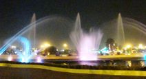
A parliamentary complex consisting of 31 buildings[19] and a new presidential palace are under construction, and expected to be complete before the 2010 general elections.[16] The city hall building resembles a Soviet government building, but has a Burmese-style roof. Behind the city hall, there is a park with a playground and artificial waterfall, which hosts a musical light show every day.[16]
Hotel zone
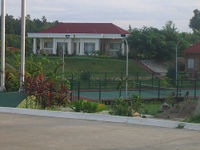
The "Hotel Zone" has a handful of villa-style hotels that dot the hills on the outskirts of town. This zone will become the city's downtown area.
There are currently twelve hotels located in or near Naypyidaw. Eight of these are located within the Naypyidaw Hotel Zone, and two are located in Laeway (Lewe) on the Yangon-Mandalay Road.[20]
Shopping
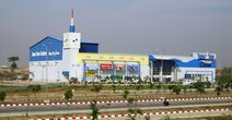
Naypyitaw Myoma Market is currently the commercial centre of Naypyidaw. Other shopping areas include Thapye Chaung Market and Junction Centre Naypyidaw. Built by the Shwe Taung Development company, Junction Centre is the first privately operated shopping centre project in Naypyidaw. It opened in August 2009.[5]
There are a few restaurants and food hawker stalls located at Myoma Market and also near Thapye Chaung Market. More dining options are available a few miles away in Pyinmana and in Lewe.[20]
Recreation

Ngalaik Lake Gardens is a small water park situated along the Ngalaik Dam, near Kyweshin Village on Ngalaik Lake (approximately seven miles from Naypyidaw). Opened in 2008, facilities at the Ngalaik Lake Gardens include water slides, natural resorts, lodging and a beach. The gardens are open to the public during Thingyan holidays.[21]
The Naypyidaw Zoological Gardens opened in 2008 with some 420 animals and a climate-controlled penguin house. It is the largest zoo in Burma.[22][23]
Also opened in 2008, the 200-acre (0.81 km2) National Herbal Park has exhibits of plants having medicinal applications from all of the major regions of Burma. There are thousands of plants at the park, representing hundreds of different species.[24]
Naypyidaw also has two golf courses (Nay Pyi Taw City Golf Course and Yaypyar Golf Course), and a gem museum.[20]
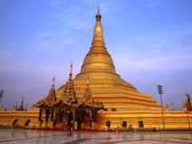
Uppatasanti Pagoda
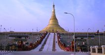
A large pagoda, called Uppatasanti Pagoda, similar in size and shape to the Shwedagon Pagoda in Yangon, was completed in 2009.[25] This new pagoda is named the Uppatasanti or "Peace Pagoda". The stake-driving ceremony for the pagoda was held on 12 November 2006.[26] The invitation card for the ceremony opened with a phrase "Rajahtani Naypyidaw (the royal capital where the king resides)". The pagoda is just 30 cm shorter than the Shwe Dagon Pagoda.[27] Uppatasanti translates roughly to "Protection against Calamity". It is the name of a sutra prepared by a monk in the early 16th century. It is to be recited in time of crisis, especially in the face of foreign invasion.[28]
International zone
The government has given two hectares of land for foreign embassies and headquarters of United Nations missions.[10]
Culture
Entertainment
The Myanmar Academy Awards are held annually in Naypyidaw given to the highest achievers in Burmese cinema.[29] There is a movie theater in the Junction Centre Mall in Naypyidaw. There are two others in nearby Pyinmana, and one in Tatkon.[20]
Economy
Demographics
Administration
The district level Naypyidaw Capital Region consists of the city proper (downtown) and eight surrounding townships.[5] Downtown is further divided into four wards. Pyinmana, Lewe, and Tatkon townships were all formerly part of Yamethin District. Oathara Thiri, Dekkina Thiri, Poppha Thiri, Zapu Thiri, and Zeyar Thiri are all new townships currently under construction. As of December 2009, most government ministry offices have been relocated to the administrative capital. Only the offices of ministries' directorates remain in Yangon.[5]
| City Proper (Wards) | Pre-Existing Townships | New Townships |
|---|---|---|
|
|
|
Education
Naypyidaw
- No. 1 Basic Education High School
Yezin (a few miles northeast of Naypyidaw and Pyinmana)
- Yezin University of Veterinary Science
- Yezin Agricultural University
- University of Forestry
Transportation
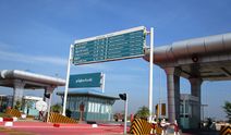
Public transport services are limited between neighborhoods.[16] The eight-lane, 323.2-km Yangon-Naypyidaw highway links Naypyidaw with Yangon directly, and is part of the 563 km-long overall Yangon-Naypyidaw-Mandalay highway. There is also a 20-lane boulevard, but like most roads in the city, it is largely empty.[30]
Rail
Naypyidaw is currently served by Pyinmana Station and Lewe Stations. Only Pyinmana station is on the Yangon to Mandalay rail line. Lewe station is located on the way from Pyinmana to Kyauk Pa Daung. It takes nine hours by train to get from Yangon to Pyinmana. Trains leave at 12:00 and arrive at 21:30 local time.[31]
Naypyidaw railway station (published as Nay Pyi Taw railway station) has been opened at milepost No. (233/0) on the between Ywataw station and Kyihtaunggan station on Yangon-Mandalay railroad with the station area of 9,000' x 4,000' and covered area of 826.5 acres. The inauguration fo the construction has been started on 8 December 2006 and Naypyidaw railway station was opened on 5 July 2009 even though the construction of overpass, Locomotive Shed, concrete road at the entrance to the station, a car park in the front of the station, No.3 lounge and platform have not been done yet.[32]
Myanma Railways has announced that passengers traveling on all trains except mail and local ones are to get off only at Nay Pyi Taw Station as they will not stop at Pyinmana Station. after the inauguration of Nay Pyi Taw Station on Sunday 5 July 2009.[33]
Air
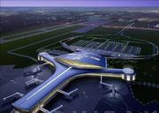
Naypyidaw Airport, also known as Ayelar Airport, is located 10 miles (16 km) southeast of the city, between the towns of Ela and Lewe. It is served by all domestic airlines--Air Bagan, Air Mandalay, Myanma Airways and Yangon Airways--with regular flights to Yangon and other cities across the country.[34] Since April 2009, the airport is undergoing major construction to handle up to 3.5 million passengers per year.[35]
Buses and cars
Government ministries run shuttle buses in the morning and evening to their respective buildings.[36]
The city has a Central Bus Station,[3] and only one taxi company, which is owned by the military.[16]
Healthcare
Nay Pyi Taw Hospital opened in 2006.[6] The nearby towns of Lewe, Pyinmana, and Tatkon each have one hospital.[20]
Communications
The city has CDMA mobile phone coverage starting from 2009. Private telephone lines to employees living in government apartments are not allowed, so public telephones must be used.[10] Naypyidaw is the only place in Burma where electricity is available 24 hours a day.[16][37]
Gallery
|

References
- ↑ 1.0 1.1 "တိုင်းခုနစ်တိုင်းကို တိုင်းဒေသကြီးများအဖြစ် လည်းကောင်း၊ ကိုယ်ပိုင်အုပ်ချုပ်ခွင့်ရ တိုင်းနှင့် ကိုယ်ပိုင်အုပ်ချုပ်ခွင့်ရ ဒေသများ ရုံးစိုက်ရာ မြို့များကို လည်းကောင်း ပြည်ထောင်စုနယ်မြေတွင် ခရိုင်နှင့်မြို့နယ်များကို လည်းကောင်း သတ်မှတ်ကြေညာ" (in Burmese). Weekly Eleven News. 2010-08-20. http://www.news-eleven.com/index.php?option=com_content&view=article&id=4375:2010-08-20-12-39-51&catid=42:2009-11-10-07-36-59&Itemid=112. Retrieved 2010-08-23.
- ↑ "News Briefs". The Myanmar Times. Myanmar Consolidated Media. 20 March 2006. http://www.myanmar.com/myanmartimes/MyanmarTimes16-309/news_brief.htm. Retrieved 1 April 2006.
- ↑ 3.0 3.1 3.2 3.3 3.4 Pedrosa, Veronica (20 November 2006). "Burma's 'seat of the kings'". Al Jazeera. http://english.aljazeera.net/NR/exeres/80733C47-7F1C-45EB-BB8E-805DB15BFE67.htm. Retrieved 21 November 2006.
- ↑ "World Urbanization Prospects 2007". 2008. http://esa.un.org/unup/p2k0data.asp. Retrieved 24 September 2008.
- ↑ 5.0 5.1 5.2 5.3 5.4 5.5 "Construction of Myanmar new capital continues". People's Daily Online. 24 December 2009. http://english.people.com.cn/90001/90777/90851/6851523.html.
- ↑ 6.0 6.1 6.2 Marshall Cavendish Corporation (2007). World and Its Peoples: Eastern and Southern Asia. Marshall Cavendish. p. 650.
- ↑ "An Introduction to the Toponymy of Burma (October 2007) - Annex A" p. 8, The Permanent Committee on Geographic Names (PCGN), United Kingdom
- ↑ http://www.irwaddy.org/article.php?art_id=9735
- ↑ "Moving Target". The Irrawaddy. 9 November 2005. http://www.irrawaddy.org/article.php?art_id=5147. Retrieved 15 July 2007.
- ↑ 10.0 10.1 10.2 Ntay, Hla Hla (February 23, 2007). Myanmar's new capital offers little in the way of luxuries. Agence France-Presse.
- ↑ "Burma's new capital stages parade". BBC News (BBC). 27 March 2006. http://news.bbc.co.uk/2/hi/asia-pacific/4848408.stm. Retrieved 6 April 2006.
- ↑ McGeown, Kate (November 8, 2005). Burma's confusing capital move. BBC News.
- ↑ McGeown, Kate (June 17, 2006). Burma's confusion over capital. BBC News.
- ↑ Zaw, Aung (November 9, 2005). Moving Target. The Irrawaddy.
- ↑ "Naypyitaw - Dictatorship by Cartography". Himal Southasian. February 2007. http://svaradarajan.blogspot.com/2007/02/dictatorship-by-cartography-geometry.html. Retrieved 29 August 2007.
- ↑ 16.0 16.1 16.2 16.3 16.4 16.5 16.6 16.7 Living in a ghost town. Bangkok Post. October 18, 2009.
- ↑ Peck, Grant (5 October 2007). "Myanmar's Remote Capital Is Still a Work in Progress". The New York Times. http://www.nytimes.com/2007/10/05/world/asia/05Naypyitaw.html?fta=y. Retrieved 20 May 2010.
- ↑ http://www.flickr.com/photos/securitywatch/238965374
- ↑ http://www.reuters.com/article/idUSTRE60G08C20100117
- ↑ 20.0 20.1 20.2 20.3 20.4 Myanmar Yellow Pages: Nay Pyi Taw Listings
- ↑ Briefing on construction of Nay Pyi Taw Ngalaik Lake Gardens
- ↑ "Myanmar unveils zoo in remote new capital". AFP. 27 March 2008. http://www.breitbart.com/article.php?id=080326075910.p8eo5136&show_article=1.
- ↑ "Built to Order: Myanmar’s New Capital Isolates and Insulates Junta". The New York Times. 24 June 2008. http://www.nytimes.com/2008/06/24/world/asia/24myanmar-sub.html?_r=1&pagewanted=all&oref=slogin.
- ↑ Myanmar sets up herbal park to promote traditional medicines
- ↑ Than Shwe offers golden lotus to Uppatasanti
- ↑ Uppatasanti Pagoda, replica of Shwedagon Pagoda in Nay Pyi Daw
- ↑ Naypyidaw’s Version of Shwedagon Pagoda Nears Completion
- ↑ Weekly Eleven News Journal, Vol. 1, No. 44 (16 August 2006), p. 9.
- ↑ "Naypyidaw’s Oscar Event". The Irrawaddy (IPG). 12 February 2008. http://www.irrawaddy.org/multimedia.php?art_id=10277.
- ↑ Tun, Aung Hla (16 January 2010). "As poll looms, Myanmar still building parliament". Reuters. http://www.reuters.com/article/idUSTRE60G08C20100117.
- ↑ "Import, export licensing moving to Naypyidaw". The Myanmar Times. Myanmar Consolidated Media. 29 May 2006. http://www.myanmar.com/myanmartimes/MyanmarTimes16-318/b001.htm. Retrieved 29 June 2006.
- ↑ "New railway station reflects dignity of Nay Pyi Taw". The New Light of Myanmar. Ministry of Information. 24 November 2009. http://myanmargeneva.org/NLM2009/eng/11Nov/n091124.pdf. Retrieved 22 July 2010.
- ↑ "Railway schedules of Pyinmana Station to be shifted to Nay Pyi Taw Station". The New Light of Myanmar. Ministry of Information. 27 June 2009. http://myanmargeneva.org/NLM2009/eng/6Jun/n090627.pdf. Retrieved 22 July 2010.
- ↑ "News Briefs (New air destinations)". The Myanmar Times. Myanmar Consolidated Media. 12 June 2006. http://www.myanmar.com/myanmartimes/MyanmarTimes16-320/news_brief.htm. Retrieved 29 June 2006.
- ↑ "Myanmar building new airport for capital". Asia One. http://www.asiaone.com/Travel/News/Story/A1Story20090425-137499.html. Retrieved 1 October 2009.
- ↑ Varadarajan, Siddharth (January 21, 2007). In phantom capital, a city slowly takes shape. The Hindu.
- ↑ Beaton, Helen (September 18, 2008). Penguins and golf in Burma's hidden capital. The Independent.
External links
- Nay Pyi Daw - A photo album
- Inside Napyidaw, The Flying Dutchman blog, 15 June 2007 (one of first two tourists to visit Naypyidaw, includes lots of photos)
- Abode of Kings in a Derelict Kingdom, Disposable Words blog, 15 June 2007 (other of first two tourists to visit Naypyidaw, more photos)
- Myanmar Yellow Pages: Nay Pyi Taw Listings
- MyanmaThadin Burmese Activists Urge Japan to Increase Pressure on Naypyidaw
|
||||||||||||||