Niamey
| Niamey | |
|---|---|
 |
|
 Niamey
|
|
| Coordinates: | |
| Country | |
| Region | Niamey Urban Community |
| Communes Urbaines | 5 Communes |
| Districts | 44 Districts |
| Quartiers | 99 Quarters |
| AreaNiamey Urban Community[1] | |
| - Total | 239.30 km2 (92.4 sq mi) |
| Elevation[2] | 207 m (679 ft) |
| Population (2006 census[3]) | |
| - Total | 774,235 |
| - Density | 2,597/km2 (6,726.2/sq mi) |
| Niamey Urban Community | |
| Time zone | WAT (UTC+1) |
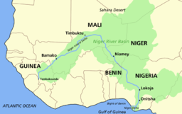
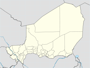
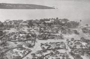
Niamey (French pronunciation: [njaˈmɛ]) is the capital of the West African nation of Niger. It is Niger's largest city, lying on the Niger River, mostly on the east bank. It is an administrative, cultural and economic center. Niamey's population, officially 774,235 at the 2006 census,[3] is estimated much higher. Niamey is located at 13°31'17" North, 2°6'19" East (13.521389, 2.105278).[4]
The city is located in a pearl millet growing region, while manufacturing industries include bricks, ceramic goods, cement and weaving.
Niamey was probably founded in the eighteenth century, but was of little importance to most of the country until the French developed a colonial post in the 1890s. This rapidly grew into an important center. In 1926 it became the capital of Niger, and the population gradually increased, from about 3,000 in 1930 to around 30,000 in 1960, 250,000 in 1980 and - by some estimates - 800,000 in 2000. The major cause of the increase has been immigration during droughts.
Contents |
Geography and Climate
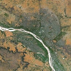
Covering an area of over 250 km² the metropolitan area sits atop two plateaus reaching 218 m in altitude, bisected by the Niger River. At Niamey, the river, running almost straight SSE from Gao, Mali, makes a series of wide bends. The city was founded on the east ("left bank") of the river as it meanders from a west to east flow to run almost directly south. A series of marshy islands begin at Niamey and extend south in the river.
The climate is hot semi-arid (Köppen climate classification BSh), with an expected rainfall of between 500 mm (20 in) and 750 mm (30 in) a year, mostly beginning with a few storms in May, then accelerating to a rainy season usually lasting from sometime in June to early September, when the rains taper off rather quickly. Most of the rainfall is from late June to mid August. There is practically no rain from mid-October to April. Niamey is remarkably hot throughout the year. Average monthly high temperatures reach 38°C (100°F) six months out of the year and in no month does average high temperatures fall below 32°C (90°F). During the dry season, particularly from November through February, nights are generally relatively cool. Average nighttime lows between November and February range from 14°C-18°C (57°F-64°F).
| Climate data for Niamey | |||||||||||||
|---|---|---|---|---|---|---|---|---|---|---|---|---|---|
| Month | Jan | Feb | Mar | Apr | May | Jun | Jul | Aug | Sep | Oct | Nov | Dec | Year |
| Source: BBC Weather [5] | |||||||||||||
Population
| Year | Population (estimate) |
|---|---|
| 1901 | 600 |
| 1930 | 3,000 |
| 1960 | 30,000 |
| 1980 | 250,000 |
| 2005 | 750,000 |
While Niamey's population has grown steadily since independence, the droughts of the early 1970s and 1980s, along with the economic crisis of the early 1980s, have propelled an exodus of rural inhabitants to Niger's largest city. Under the Military government of General Seyni Kountché, there were strict controls on residency, and the government would regularly round up and "deport" those without permits back to their villages.[6] The growing freedoms of the late 1980s and 1990s, along with the Tuareg Rebellion of 1990s and famine in the 2000s, have reinforced the process of immigration, with large informal settlements appearing on the outskirts of the cities. Noticeable in the city's centre since the 1980s are groups of poor, young, or handicapped beggars. Within the richer or more trafficked neighbourhoods, these beggars have in fact formed a well regulated hierarchical system in which beggars garner sadaka (alms) according to cultural and religious norms.[6]
Sites and institutions
Attractions in the city include the Niger National Museum, incorporating a zoo, a museum of vernacular architecture, a craft centre, and exhibits including dinosaur skeletons and the Tree of Ténéré. There are also American, French and Nigerien cultural centres, seven major market centers including the large Niamey Grand Market, a traditional wrestling arena and a horse track.
The city is also the site of Diori Hamani International Airport, the National School of Administration, Abdou Moumouni University, which lies on the right bank of the river, and many institutes (Centre numérique de Niamey, IRD, ICRISAT, Hydrologic Institute, etc.) AMU has seen a number of protest actions over the years, including the 2006 Abdou Moumouni University protests.
Several hospitals are located in Niamey, including the National Hospital and Lamordé University Hospital.
In December 2005 it was the host of the Jeux de la Francophonie.
Niamey makes up a special capital district of Niger, which is surrounded by the department of Tillabéri.
Street addressing
Many major West African cities only developed street numbering schemes in the 1990s. Niamey's 2001-2002 street addressing project, although coming later to this process, was regarded as somewhat of a model in its speed, efficiency, and cost. Although receiving some funding and advisement from the International Agency of Mayors of the Francophonie (AIMF), the process was planned and carried out by the Niamey's Municipal government (Communaute Urbaine de Niamey) in 15 months during 2001-2002. A wide ranging public education campaign was carried out during the planning stages, and elements of the Tax assessment and utility planning authorities collaborated in the block by block assessment of the city, and a street address database was compiled with this data and the name of inhabitants or business for every doorway (over 50,000 addresses). The address system divides the city into 44 formal, named "Districts", based on pre-existing neighbourhoods. Each District is given a two letter prefix ("Grand Marché", for instance, is "GM"). All streets are numbered ordinarily, with streets roughly parallel to the river using even numbers, and cross streets odd numbers. Doorway numbers (addresses) begin at the river and increase as they move away, with alternating even-odd address numbers on opposite sides of the street. Thus a street address in "Grand Marché" District might be "4735, Rue GM 12, Niamey" ("Rue" being the French word for street). 100,000 street signs were installed during the process.[7]
Religion
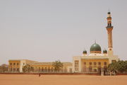
More than 90% of Niger is populated by Muslims, and as such Niamey hosts the largest mosque in the country, the Grand Mosque of Niamey. The city is the headquarters of the Roman Catholic Archdiocese of Niamey.
Niamey Urban Community
The city of Niamey itself is governed as an autonomous first-level administrative block, the Niamey Urban Community (fr. Communauté Urbaine de Niamey, CUN). It includes five Urban Communes, divided into 44 "Districts" and 99 "Quartiers", including formerly independent towns. It is a co-equal first division subdivision with the seven Regions of Niger. The Niamey Urban Community includes an elected government and mayor of the government of greater Niamey.
Until 1998, it was part of Tillabery Region, which prior to 1992 was named the Niamey Department, and remains surrounded on all sides by Tillabery Region.[8] Under the devolution process begun in the mid 1990s[9] and formalised in the 1999 Constitution of Niger, the CUN contains five "Urban Communes" and no "Rural Communes". As all Nigerien Urban Communes, they are divided into Quarters ("Quartiers") with elected boards.
The CUN includes 99 Quarters:[10]
- Niamey I commune, 20 Quarters
- Niamey II commune, 17 Quarters
- Niamey III commune, 17 Quarters
- Niamey IV commune, 17 Quarters
- Niamey V commune, 28 Quarters
The CUN includes land where there were formerly several surrounding towns and villages which the city of Niamey has now annexed. These include Soudouré, Lamordé, Gamkallé, Yantala, and Gaweye.[8]
The CUN covers a territory of 239.30 km2[11], or 0.02% of the nation's territory.[12]
References
- ↑ ADAMOU Abdoulaye. Parcours migratoire des citadins et problème du logement à Niamey. REPUBLIQUE DU NIGER UNIVERSITE ABDOU MOUMOUNI DE NIAMEY Faculté des Lettres et Sciences Humaines DEPARTEMENT DE GEOGRAPHIE(2005), p. 34
- ↑ "FallingRain Map - elevation = 207m". http://www.fallingrain.com/world/NG/8/Niamey.html.
- ↑ 3.0 3.1 African researcher visits Oklahoma. p. 2
- ↑ "earth-info.nga.mil". http://earth-info.nga.mil/gns/html/cntry_files.html.
- ↑ "Average Conditions Niamey, Niger". BBC Weather. http://www.bbc.co.uk/weather/world/city_guides/results.shtml?tt=TT000480. Retrieved August 18, 2009.
- ↑ 6.0 6.1 Patrick Gilliard, and Laurent Pédenon "Rues de Niamey, espace et territoires de la mendicité" Politique africaine, Paris (October 1996) no.63 pp. 51-60.
- ↑ World Bank, Catherine Farvacque-Vitković, Lucien Godin, Hugues Leroux, Florence Verdent, Roberto Chavez. Street Addressing and the Management of Cities. World Bank Publications, (2005) ISBN 9780821358153 pp. 15, 30, 85-89.
- ↑ 8.0 8.1 Decalo, Samuel (1997). Historical Dictionary of the Niger (3rd ed.). Boston & Folkestone: Scarecrow Press. ISBN 0810831368. pp. 225-227
- ↑ Haut Commissariat à la Réforme Administrative: loi N°2002-016 bis du 11 une 2002.
- ↑ Adamou Abdoulaye. Parcours migratoire des citadins et problème du logement à Niamey. Département de Géographie, Faculté des Lettres et Sciences Humaines, Université Abdou Moumouni de Niamey (2005). (French)
- ↑ FAO (2003), Section VI
- ↑ Amadou Oumarou. Etat et contexte de la fourniture des services publics dans la commune urbaine de Say. LASDEL - Laboratoire d'études et recherches sur les dynamiques Sociales et le développement local, Niamey, Niger. (April 2007)
- Decalo, Samuel (1997). Historical Dictionary of the Niger (3rd ed.). Boston & Folkestone: Scarecrow Press. ISBN 0810831368.
- Geels, Jolijn (2006). Niger. Chalfont St Peter, Bucks / Guilford, CT: Bradt UK / Globe Pequot Press. ISBN 9781841621524.
External links
- Niamey travel guide from Wikitravel
- Niger Assemblee Nationale official website
- Mission of Niger to the United Nations official website
- BBC News Country Profile - Niger
- CIA World Factbook - Niger
- Niger at the Open Directory Project
- US State Department - Niger includes Background Notes, Country Commercial Guides and major reports
|
||||||||||||||||||||||||||
|
||||||||
|
|||||||||||||||||||||||||