Quito
| Quito | |||
|---|---|---|---|
| — City — | |||
| San Francisco de Quito | |||
 |
|||
|
|||
| Nickname(s): Luz de América (Light of America), La ciudad de los cielos (The city of the heavens) | |||
 Quito
|
|||
| Coordinates: | |||
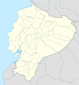
| Country | Ecuador | ||
| Province | Pichincha | ||
| Canton | Quito | ||
| Foundation | December 6, 1534 | ||
| Founder | Sebastián de Belalcázar | ||
| Named for | Quitu | ||
| Urban parishes |
32 urban parishes
Argelia, La
Belisario Quevedo Carcelén Centro Histórico Chilibulo Chillogallo Chimbacalle Cochapamba Comité del Pueblo Concepción, La Condado, El Cotocollao Ecuatoriana, La Ferroviaria, La Guamaní Inca, El Iñaquito Itchimbía Jipijapa Kennedy Libertad, La Magdalena Mariscal Sucre Mena, La Ponceano Puengasí Quitumbe Rumipamba San Bartolo San Juan Solanda Turubamba |
||
| Government | |||
| - Type | Mayor and council | ||
| - Governing body | Municipality of Quito | ||
| - Mayor | Augusto Barrera | ||
| - City council |
List of councilmembers
|
||
| Areaapprox. | |||
| - City | 324 km2 (125.1 sq mi) | ||
| - Water | 0 km2 (0 sq mi) | ||
| - Metro | 4,204 km2 (1,623.2 sq mi) | ||
| Elevation | 2,850 m (9,350 ft) | ||
| Population (2001) | |||
| - City | 1,397,698 | ||
| - Density | 4,313.9/km2 (11,172.9/sq mi) | ||
| - Metro | 1,842,201 | ||
| - Metro density | 438.2/km2 (1,134.9/sq mi) | ||
| - Demonym | Quiteño(-a) | ||
| Time zone | ECT (UTC-5) | ||
| Postal code | EC1701 (new format), P01 (old format) | ||
| Area code(s) | (0)2 | ||
| Website | http://www.quito.gov.ec | ||
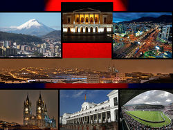
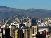
San Francisco de Quito, most often called Quito (Spanish pronunciation: [ˈkito]), is the capital city of Ecuador in northwestern South America. It is located in north-central Ecuador in the Guayllabamba river basin, on the eastern slopes of Pichincha,[1] an active stratovolcano in the Andes mountains. With a population of 1,397,698 according to the last census (2001), and, as estimated by the municipality, approximately 1,504,991 in 2005,[2] Quito is the second most populous city in Ecuador, after Guayaquil. It is also the capital of the Pichincha province and the seat of Metropolitan District of Quito. The canton recorded a population of 1,842,201 residents in the 2001 national census. In 2008 the city was designated as the headquarters of the Union of South American Nations.[3]
The elevation of the city's central square (Plaza de La Independencia or Plaza Grande[4]) is 2,800 m (about 9,186 ft), making Quito the second-highest administrative capital city in the world (after La Paz, Bolivia), and the highest legal capital (ahead of Sucre, also in Bolivia, and Bogotá, Colombia).
The central square of Quito is located about 25 km (15 miles) south of the equator; the city itself extends to within about 1 km (0.6 miles) of zero latitude. A monument and museum marking the general location of the equator is known locally as la mitad del mundo (the middle of the world), to avoid confusion, as the word ecuador is Spanish for equator.
Quito, along with Krakow, were the first Cultural Heritage Sites declared by UNESCO in 1978.[5]
Contents |
History
Pre-Columbian
Quito's origins date back to the first millennium, when the Quitu tribe occupied the area and eventually formed a commercial center. According to Juan de Velasco's 1767 book Historia del Reino de Quito, the Quitu were conquered by the Caras tribe, who founded the Kingdom of Quito about 980 A.D. For more than four centuries under the kings (shyris) of the Caras, the Kingdom of Quito dominated much of highlands of modern Ecuador. The Caras and their allies were narrowly defeated in the epic battles of Tiocajas and Tixán in 1462, by an army of 250,000 led by Túpac Inca, the son of the Emperor of the Incas. After several decades of consolidation, the Kingdom of Quito became integrated into the Incan Empire. In 1534 the Caras/Quitu people were conquered by the Spanish.
Colony

Indigenous resistance to the Spanish invasion continued during 1534, with Diego de Almagro founding Santiago de Quito (in present day Colta, near Riobamba) on August 15 of that same year, later to be renamed San Francisco de Quito on August 28. The city was later moved to its present location and was refounded on December 6, 1534 by 204 settlers led by Sebastián de Benalcázar, who captured Rumiñahui and effectively ended any organized resistance.[6] Rumiñahui was then executed on January 10, 1535. On March 14, 1541, Quito was declared a city and on February 14, 1556, was given the title Muy Noble y Muy Leal Ciudad de San Francisco de Quito ("Very Noble and Loyal City of San Francisco of Quito"). In 1563, Quito became the seat of a royal audiencia (administrative district) of Spain and became part of the Viceroyalty of Peru with its capital in Lima (see Real Audiencia de Quito).
The Spanish promptly established Roman Catholicism in Quito, with the first church (El Belén) built even before the city had been officially founded. In January 1535, the San Francisco Convent was constructed, the first of about 20 churches and convents built during the colonial period. The Spanish actively converted the indigenous population and used them as slave labor for construction, especially in the early colonial years. The Diocese of Quito was established in 1545 and was elevated to the Archdiocese of Quito in 1849.
In 1809, after nearly 300 years of Spanish colonization, Quito was a city of about 10,000 inhabitants. On August 10, 1809, a movement was started in Quito that aimed for political independence from Spain. On that date, a plan for government was established that placed Juan Pío Montúfar as president with various other prominent figures in other positions of government. However, this initial movement was ultimately defeated on August 2, 1810, when Imperial troops came from Lima, Peru, and killed the leaders of the uprising along with about 200 inhabitants of the city. A chain of conflicts concluded on May 24, 1822, when Antonio José de Sucre, under the command of Simón Bolívar, led troops into the Battle of Pichincha. Their victory marked the independence of Quito and the surrounding areas.
Gran Colombia
Just days after the Battle of Pichincha, on May 24, 1822, the leaders of the city proclaimed their independence and allowed the city to be annexed to the Republic of Gran Colombia. Simón Bolívar went to Quito on June 16, 1822, and was present at the signing of the Colombian Constitution on June 24, 1822. When the Gran Colombia dissolved in 1830, Quito became the capital of the newly formed Republic of Ecuador.
Republican era
In 1833, members of the Society of Free Inhabitants of Quito were assassinated by the government after they conspired against it, and on March 6, 1845, the Marcist Revolution began. Later, in 1875, the country's president, Gabriel García Moreno, was assassinated in Quito. Two years later, in 1877, Archbishop José Ignacio Checa y Barba was killed by poisoning while he was giving mass.
In 1882, insurgents arose against the regime of dictator Ignacio de Veintemilla. However, this did not end the violence that was occurring throughout the country. On July 9, 1883, the liberal commander Eloy Alfaro participated in the Battle of Guayaquil, and later, after more conflict, became the president of Ecuador on September 4, 1895. Upon completing his second term in 1911, he moved to Europe. When he returned to Ecuador in 1912 and attempted a return to power, he was arrested on January 28, 1912; thrown in prison; and assassinated by a mob that had stormed the prison. His body was dragged through the streets of Quito to a city park, where it was burned.
In 1932, the Four Days' War broke out. This was a civil war that followed the election of Neptalí Bonifaz and the subsequent realization that he carried a Peruvian passport. Workers at a major textile factory went on strike in 1934, and similar unrest continues to the present day. On February 12, 1949, a realistic broadcast of H. G. Wells' novel The War of the Worlds led to citywide panic and the deaths of more than twenty people who died in fires set by mobs.[7]
In recent years, Quito has been the focal point of large demonstrations that led to the ousting of presidents Abdalá Bucaram (February 5, 1997), Jamil Mahuad (January 21, 2000), and Lucio Gutiérrez (April 20, 2005).
Geography
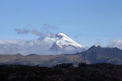
Quito is located in the northern highlands of Ecuador in the Guayllabamba river basin. The city has been built on a long plateau lying on the east flanks of the Pichincha volcano. The valley of Guayllabamba River where Quito lies is flanked by volcanoes, some of them snow-capped, that can be visible from the city on a clear day. Some of the volcanoes on the Central Cordillera (Royal Cordillera), east of Quito, surrounding the Guayllabamba valley are Cotopaxi, Sincholagua, Antisana, and Cayambe. Some of the volcanoes of the Western Cordillera, to the west of the Guayllabamba valley, are Illiniza, Atacazo, Pichincha, and Pululahua (which has the Pululahua Geobotanical Reserve).
Nearby volcanoes
Quito's closest volcano is Pichincha, looming over the western side of the city. Quito is also the only capital in the world to be directly menaced by an active volcano. Pichincha volcano has several summits, among them Rucu Pichincha at 4700 metres above sea level and Guagua Pichincha at 4794 metres. Guagua Pichincha is active and being monitored by volcanologists at the geophysical institute of the national polytechnic university. The largest eruption occurred in 1660 when more than 10 inches (25 cm) of ash covered the city.[8] There were three minor eruptions in the 1800s. The latest eruption was recorded on August 23, 2006, when a few puffs of smoke and a large amount of ash were deposited on the city. Although not devastating, the eruption caused significant disruption of activities, including closing of the international airport. It is unlikely that any serious activity will occur in the near future, and the topography of the volcano is such that, even if a major eruption were to occur, lava flows would head into the almost-unpopulated areas west of the volcano, sparing Quito, which lies to the east.
Activity in other nearby volcanoes also can affect the city. In November 2002, after an eruption in the volcano Reventador, the city was showered with a layer of fine ash particles to a depth of several centimeters.[9]
Climate
Under the Köppen climate classification, Quito has a Subtropical highland climate. Because of its elevation and its proximity to the equator, Quito has a fairly constant cool climate, with spring-like weather year-round. The average temperature at noon is 18.7 °C (65.7 °F) with a normal night-time low of 9.3 °C (48.7 °F).[10] The annual average temperature is 14.0 °C (57.2 °F).[11] The city experiences only two seasons: dry and wet. The dry season, June through September (4 months), is referred to as summer; the wet season, October through May (8 months), is referred to as winter. Annual precipitation, depending on location, is approximately 1,010 mm (40 in)
| Climate data for Quito | |||||||||||||
|---|---|---|---|---|---|---|---|---|---|---|---|---|---|
| Month | Jan | Feb | Mar | Apr | May | Jun | Jul | Aug | Sep | Oct | Nov | Dec | Year |
| Source: [12] | |||||||||||||
Demographics
Population
This is population figure for the city proper as determined by the last census conducted in 2001. The number does not reflect the population of the whole canton, which also includes the surrounding rural parishes (parish seats and their surroundings), which are separate from the city.
- Population: 1,397,698
- Number of households: 419,845
- Illiteracy rate: 3.6%
- Unemployment rate: 8.9%
- Underemployment rate: 43.8%
Topographical zones
Quito is divided into three areas, separated by hills:
- Central: houses the colonial old city.
- Southern: is mainly industrial and residential, and a working-class housing area.
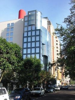
- Northern: is the modern Quito, with high-rise buildings, shopping centers, the financial district, and upper-class residential areas and some working-class housing areas. It is the location of Mariscal Sucre International Airport.[13]
Economy
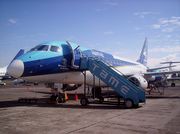
TAME, an airline of Ecuador, has its headquarters in Quito.[14]
Politics
Governance
Quito is governed by a mayor and a 15-member city council. The mayor is elected to a four-year term and can be re-elected. The position also doubles as Mayor of the Metropolitan District of Quito (the canton).
| Recent mayors | |||
|---|---|---|---|
| Start | End | Name | Political party |
| 1940 | 1944 | Jacinto Jijón y Caamaño | |
| 1956 | 1960 | Carlos Andrade Marín | |
| 1960 | 1968 | Julio Moreno Espinoza | |
| 1968 | 1972 | Jaime del Castillo Álvarez | |
| 1972 | 1980 | Sixto Durán Ballén | PSC |
| 1980 | 1984 | Álvaro Pérez | PLRE |
| 1984 | 1988 | Gustavo Herdoíza | |
| 1988 | 1992 | Rodrigo Paz Delgado | DP |
| 1992 | 1998 | Jamil Mahuad | DP |
| 1998 | 2000 | Roque Sevilla | DP |
| 2000 | 2009 | Paco Moncayo Gallegos | ID |
| 2009 | Andrés Vallejo Arcos | ||
| 2009 | Augusto Barrera Guarderas | Alianza PAIS | |
Urban parishes
In Ecuador, cantons are subdivided into parishes. These subdivisions are called parishes because they were originally used by the Catholic Church, but, along with the secularization and liberalization of the Ecuadorian state, the political parishes were spun off the ones used by the church. Parishes are called urban if they are within the boundaries of the seat (capital) of their corresponding canton, and rural if they are outside of those boundaries. Inside Quito (the city proper), the way in which the city is subdivided into urban parishes depends on the organizations which use those parishes (e.g., the municipality, the electoral tribunals, the postal service, the Ecuadorian statistics institute). The urban parishes of different types are not necessarily coterminous nor the same in number or name.
Rural parishes
Quito's main rural parishes include the satellite city of Cumbaya and Tumbaco, both located in the Northeastern valley of Tumbaco. Cumbaya is the home of many important schools and of Universidad San Francisco de Quito. The area includes many shopping centers and churches such as the Iglesia de Cumbaya, Iglesia de Tumbaco and the Iglesia de Miravalle ([1]).
Municipal/administrative urban parishes (cabildos)
As of 2008, the municipality of Quito divided the city into 32 urban parishes. These parishes, which are used by the municipality for administrative purposes, are also known as cabildos[15] since 2001. Since the times of the Metropolitan District of Quito, parishes of this type are also grouped into larger divisions known as municipal zones (zonas municipales). These parishes are as follows:
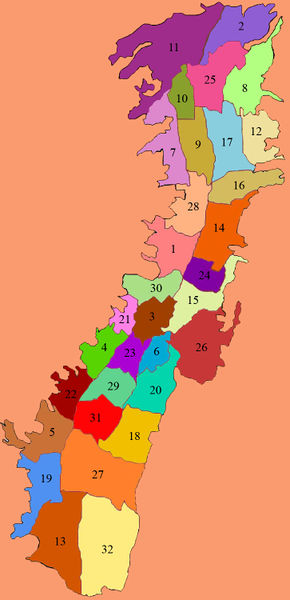
- Argelia, La
- Belisario Quevedo
- Carcelén
- Centro Histórico
- Chilibulo
- Chillogallo
- Chimbacalle
- Cochapamba
- Comité del Pueblo
- Condado, El
- Concepción, La
- Cotocollao
- Ecuatoriana, La
- Ferroviaria, La
- Guamaní
- Inca, El
- Iñaquito
- Itchimbía
- Jipijapa
- Kennedy
- Libertad, La
- Magdalena
- Mariscal Sucre
- Mena, La
- Ponceano
- Puengasí
- Quitumbe
- Rumipamba
- San Juan
- San Bartolo
- Solanda
- Turubamba
Electoral urban parishes (CNE/TEP)
Electoral urban parishes are used by the Consejo Nacional Electoral (CNE) (until the 2008 Ecuadorian constitution known as Tribunal Supremo Electoral (TSE)) and by the Tribunal Electoral de Pichincha (TEP) in order to distribute vote ballots and count electoral votes. Unlike rural parishes, urban parishes do not have and do not elect a junta parroquial (parochial committee/junta). Within each of these parishes, there are one or more schools in which elections take place, typically on Sundays. As of the 2008 Ecuadorian referendum, there were 19 urban parishes of this type, as follows:[16]
- Alfaro
- Benalcázar
- Chaupicruz
- Chillogallo
- Cotocollao
- El Salvador
- González Suárez
- Guápulo
- La Floresta
- La Libertad
- La Magdalena
- La Vicentina
- San Blas
- San Marcos
- San Roque
- San Sebastián
- Santa Barbara
- Santa Prisca
- Villa Flora
Later in 2008, the relatively small González Suárez parish was removed from the list,[17] prior to the 2009 elections.
Ecclesiastical parishes
The Roman Catholic Archdiocese of Quito divides the city into 167 parishes, which are grouped into 17 zones.[18]
Jewish Community
The Jewish community of Ecuador, with domicile in Quito, has about 500 members. However, this number is decreasing because young people are emigrating to study in Israel or elsewhere abroad and not returning. There is a Jewish school in Quito, the Colegio Experimental Alberto Einstein, established in 1973, which serves both Jewish and non-Jewish students from kindergarten through the twelfth grade. All Jewish holidays are celebrated by the school, and Hebrew and other Jewish studies are taught there. The school has an excellent reputation and superb pre-college preparatory program. The Jewish community of Quito has its own building, a home for the aged, and a synagogue that holds services on the Sabbath and holidays.
Transportation
Ground transport
Road transport
Public road transport
The MetrobusQ network, also known as "Red Integrada de Transporte Público", is the bus rapid transit system running in Quito, and it goes through the city from south to north. It's divided into three sections—the green line (the central trolleybus, known as El Trole), the red line (the north-east Ecovía), and the blue line (the north-west Corredor Central). In addition to the bus rapid transit system, there are many buses running in the city. The buses have both a name and a number, and they have a fixed route. Taxi cabs are all yellow, and they have meters that show the fare. There are nearly 8,800 registered taxicabs.[19]
Private road transport
Although public transportation is the primary form of travel in the city, including fleets of taxis that constantly cruise the roadways, the use of private vehicles has increased substantially during the past decade.[20]
Because of growing road congestion in many areas, there are plans to construct a light rail system, which would replace the northern portion of the Trole.[21] It is hoped to begin construction in 2010.
Roads, avenues and streets
Because Quito is about 40 km (24.85 miles) long and 5 km (3.1 miles) at its widest, most of the important avenues of the city extend from north to south. The two main motorways that go from the northern part of the city to the southern are Avenue Oriental (Corridor Periférico Oriental) on the eastern hills that border the city, and Avenue Occidental on the western side of the city on the Pichincha volcano. The street 10 de Agosto also runs north to south through most of the city, running down the middle of it. Because of the hills and the city's curved shape, a grid pattern is extremely difficult to imply. The historic centre of the city is based on a grid pattern, despite the hills, with the streets Venezuela, Chile, García Moreno, and Guayaquil being the most important.
Some of the most important avenues in Quito are:
|
|
Railroad transport
There is a railroad that goes through the southern part of Quito and passes through the Estación de Chimbacalle. It is managed by the Empresa de Ferrocarriles Ecuatorianos (EFE). This form of transport is nowadays used mostly for tourism.
Air transport
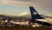
Mariscal Sucre International Airport (IATA airport code: UIO) serves as the city's principal airport for passenger travel and freight. Its runway is 3120 metres long and is capable of handling many types of large aircraft. The main terminal is located on Avenue Amazonas. The airport is located 10 kilometres north of the city's centre, within driving distance to the main business center. Because of tall buildings and fog at night, landing from the south is not as easy as at many other airports. Its domestic flights go to Guayaquil, Cuenca, Lago Agrio, Coca, Tarapoa, Esmeraldas, Manta, Portoviejo, Macas, Tulcán, and many others. Flights to the Galápagos Islands are reached via Guayaquil. Several international airlines have offices in Quito; most of them are around Avenue Amazonas. The airport provides international connections to Madrid, Amsterdam, New York, Atlanta, Houston, Miami, Bogotá, Medellín, Cali, Lima, Santiago, Panama City, San José, Rio de Janeiro, São Paulo, and many others. The construction of a new airport in the rural parish of Tababela, in the adjacent valley outside the city limits, began in 2006 and will be finished by 2010. The Mariscal Sucre International Airport will then become a big park.
Points of interest
The official travel information site, run by the Municipality Quito Visitors' Bureau, is www.quito.com.ec .
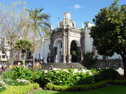
Historic centre
| City of Quito* | |
|---|---|
| UNESCO World Heritage Site | |
| State Party | |
| Type | Cultural |
| Criteria | ii, iv |
| Reference | 2 |
| Region** | Latin America and the Caribbean |
| Inscription history | |
| Inscription | 1978 (2nd Session) |
| * Name as inscribed on World Heritage List. ** Region as classified by UNESCO. |
|
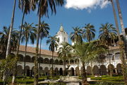
According to UNESCO, Quito has the largest, best-preserved, and least-altered historic centre (320 hectares) in Latin America,[22] despite several earthquakes. It was the first city that was inscribed onto the UNESCO World Heritage List, in 1978.[22] Some of the churches are:
- Cathedral of Quito
- Church of the Society of Jesus (La Compañía)
- Church and Convent of St. Francis (San Francisco)
- Church and Convent of St. Dominic (Santo Domingo)
- Church and Convent of La Merced
- Basílica del Voto Nacional
El Panecillo
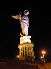
El Panecillo is a hill located in the middle west of the city at an altitude of about 9,895 ft (3,016 m) above sea level. A monument to the Virgin Mary is located on top of El Panecillo and is visible from most of the city of Quito. In 1976, the Spanish artist Agustín de la Herrán Matorras was commissioned by the religious order of the Oblates to build a 134.5 ft (41 m)–tall aluminum monument of a madonna, which was assembled on a high pedestal on the top of Panecillo. Made of approximately 7,000 pieces of aluminum, the monument was inaugurated on March 28, 1976, by the 11th archbishop of Quito, Cardinal Pablo Muñoz Vega.
The figure stands on top of a globe, standing on top of a chained snake , symbolizing her triumph over evil (classic madonna iconography). What is not so traditional, however, is her wings. The monument was inspired by the famous "Virgen de Quito" (Quito's Madonna), also known as "the dancer" sculpted by Bernardo de Legarda in 1734, which now decorates the main altar at the Church of St. Francisco. This madonna represents a turning point of the Quito School of Art (one of the most renowned of the Americas) because it shows a figure with great movement (practically dancing), which is in contrast to the traditional static madonnas produced during the 18th century.
La Mariscal
La Mariscal Sucre in Quito has earned the nickname "Gringolandia" because of its popularity with western tourists. While lacking in major tourist attractions, it is home to a number of clubs, bars and restaurants that cater to visitors. There are also many travel agents that specialize in western travel.
Parks
Metropolitano
Parque Metropolitano Guanguiltagua[23] is the largest urban park in South America at 1,376 acres (5.5 km²) (as reference, New York's Central Park is 843 acres (341 ha). The park is located in northern Quito, on the hill of Bellavista behind Estadio Olímpico Atahualpa. The park is suited for mountain biking, walking, and running. Most of it is eucalyptus forest with trails, but there also are numerous sculptures on display. The park has four sites that can be used for picnics or barbecues, and the eastern section has a view of Cotopaxi, Antisana, and the Guayllabamba river basin.
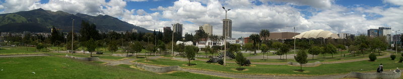
La Carolina
La Carolina[24] is a 165.5-acre (670,000 m²) park in the centre of the Quito main business area, bordered by the avenues Río Amazonas, de los Shyris, Naciones Unidas, Eloy Alfaro, and de la República. This park started from the expropriation of the farm La Carolina in 1939. The design of the park was made by the Dirección Metropolitana de Planificación Territorial (DMPT). Pope John Paul II headed a great mass in the park during his visit to Ecuador in 1985. A giant cross has been built in this place.
Quiteños gather at La Carolina mostly on weekends to play soccer, basketball, and ecua-volley (an Ecuadorian variation of volleyball with less emphasis on spiking, which allows more of a throw). Some of the other activities are aerobics, kite flying, running, snacking, and people watching. The southern part of the park has a small pond where paddle boats can be rented and a skatepark for bicyclists and skateboarders. Artists are known to perform on weekends at the park. In the western part of the park, visitors will find the Quito Exhibition Center[25] with different exhibits every month, the Quito botanical gardens,[26] and a Vivarium.
La Carolina more or less resembles New York City's Central Park, since both La Carolina and Central Park are surrounded by tall buildings in relation to the area of both parks.
El Ejido
El Ejido[27] is the third-largest park of Quito (after Metropolitan and La Carolina), and it divides the old part of the city from the modern one. This park is known for handicrafts available for sale every Saturday and Sunday, with all pricing subject to negotiation (that is, haggling). Local painters sell copies of paintings by Oswaldo Guayasamín [2], Eduardo Kingman, and Gonzalo Endara Crow. Otavaleños sell traditional sweaters, ponchos, carpets, and jewelry.
La Alameda
The long triangular La Alameda is located at the beginning of street Guayaquil, where the historic centre begins. It has an impressive monument of Simón Bolivar at the apex. There are several other interesting monuments in this park. In the centre of the park is the Quito Observatory, which was opened by President García Moreno in 1873 and is the oldest observatory in Latin America. It is used for both meteorology and astronomy. At the north end of the park are two ornamental lakes, where rowboats can be rented.
TeleferiQo
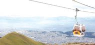
The Aerial tramway Station at Cruz Loma (part of the Pichincha mountain complex at about 13,123 ft (4,000 m). Since July 2005, Quito has had an aerial tramway, known as the "Telefériqo", from the city centre to the hill known as Cruz Loma on the east side of the Pichincha volcano. The ride takes visitors to an altitude of about 13,400 ft (more than 4,100 m) where they find a number of restaurants, coffee shops, and a variety of stores. There are also trails for hiking and areas where pictures can be taken of Quito. Because of the increased altitude and the wind on the mountain, it is considerably cooler.
Besides the aerial tramway to Cruz Loma, the Telefériqo as a whole is a visitor centre that includes an amusement park (Vulqano Park), fine-dining restaurants, Go Karts, Paint Ball, shopping malls, an extensive food court, and other attractions.
Outside the city
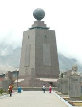
La Mitad del Mundo[28] (the middle of the world) is a small village administered by the prefecture of the province of Pichincha, 22 mi (35 km) north of Quito. The village features a large monument, built on the site where the equator was thought to have crossed in the early 1980s. There is also a museum that contains a model of Quito, a planetarium, various exhibits, several restaurants, an open arena that is occasionally used for folkloric-dance performances, and a small chapel where couples can marry with one spouse standing in the northern hemisphere and the other in the southern. It has since been determined, with the use of Global Positioning System technology, that the actual equator is some 240 meters north of the monument area.
Pululahua Geobotanical Reserve, located a few miles northwest from La Mitad del Mundo, contains the Pululahua volcano, whose caldera (crater) is visible from a spot easily accessible by car. It is believed to be one of only a few in the world with human inhabitants.
Quito Zoo,[29] located near the rural parish of Guayllabamba, about 12 mi (20 km) outside Quito, has the biggest collection of native fauna in Ecuador, including several kinds of animals that are sometimes targeted in Ecuador in the illegal fur trade.
Some of the other nearby natural attractions are:
- Antisana Ecological Reserve
- Cayambe - Coca Ecological Reserve
- Papallacta & Oyacachi thermal springs
- Cotopaxi National Park
- Mindo Nambillo cloud forest
- Illiniza volcano
- Pasochoa Wildlife Refuge
- Pichincha (Rucu & Guagua) volcanoes
Education
Universities
According to the National Council for Higher Education of Ecuador (CONESUP), these are the universities founded before the year 2006 in or around Quito:[30]
Museums
For a full listing of Museums, see the Quito Visitors' Bureau's page
Museo de la Ciudad - A museum dedicated to the history of Quito. Located just east of the Plaza de Santo Domingo.[31]
Museo Casa de Sucre - This museum is dedicated to life of Mariscal José Antonio de Sucre, a hero of Ecuadorian independence. The museum is located in his old home. The ground floor has an array of weapons and military relics, many of which belonged to Sucre himself. The second floor has been restored to what it might have looked like in Sucre's time.[32]
Museo Nacional del Banco Central del Ecuador - This art museum houses 5 displays. Each one covers a different time period, ranging from prehistory to modern Ecuador.[33]
Sports
Professional football teams

Quito is the home city of six prominent football clubs in Ecuador. Domestically, the city's top three club (El Nacional, Deportivo Quito and LDU Quito) have won a combined 26 national championships, which accounts for over half of all championships won.
The teams in Ecuador's First Division (Serie A and Serie B) are:
- Deportivo Quito
- El Nacional
- ESPOLI
- LDU Quito
- Universidad Católica
- Universidad Tecnológica Equinoccial
Twin towns and sister cities
Quito is twinned with:
 Madrid, Spain[34]
 Buenos Aires, Argentina
 Bogotá, Colombia
 Managua, Nicaragua
 Louisville, Kentucky, USA[35]
- Coral Gables, USA[35]
- New York City, USA
 Toronto, Canada
 La Paz, Bolivia
 Dubai, UAE
 Buxton, United Kingdom
 Santo Domingo, Dominican Republic
 Kraków, Poland[36]
See also
- Charles Marie de La Condamine
- Cuarenta
- Cuenca
- Ecuador
- El Panecillo
- Guayaquil
- List of Latin American artists
- Mitad del Mundo
- Wikitravel:Quito
- World66:Quito
References
- ↑ Volcán Guagua Pichincha. Instituto Geofísico. http://www.igepn.edu.ec/VOLCANES/PICHINCHA/general.html. Retrieved 2008-08-01 (Spanish)
- ↑ Metropolitan District of Quito population projection. Directorate of Territorial Planning and Public Services. http://www4.quito.gov.ec/mapas/indicadores/proyeccion_zonal_archivos/sheet001.htm. Retrieved 2008-08-01 (Spanish)
- ↑ Security Watch: South American unity. International Relations and Security Network. http://www.isn.ethz.ch/news/sw/details.cfm?ID=19022. Retrieved 2008-08-01
- ↑ Plaza Grande. Sitio Oficial Turístico de Quito. http://www.quito.com.ec/index.php?page=shop.product_details&flypage=shop.flypage&product_id=228&category_id=&manufacturer_id=&option=com_virtuemart&Itemid=113. Retrieved 2008-08-01 (Spanish)
- ↑ UNESCO World Heritage List
- ↑ (– Scholar search) City. Quito Distrito Metropolitano. http://www.quito.gov.ec/ciudad/c_ciudad2.htm. Retrieved 2008-08-02 (Spanish)
- ↑ Brown, Robert J. (2004). Manipulating the Ether. McFarland. pp. 251–252. ISBN 0786420669
- ↑ Naumova, En; Yepes, H; Griffiths, Jk; Sempértegui, F; Khurana, G; Jagai, Js; Játiva, E; Estrella, B (Jul 2007). "Guagua Pichincha". Environmental health : a global access science source (National Environmental Satellite, Data, and Information Service) 6: 21. doi:10.1186/1476-069X-6-21. PMID 17650330. PMC 1947976. http://www.osei.noaa.gov/guagua.html. Retrieved 2008-08-02
- ↑ Le Pennec, J-L. et al. (2006). "Fourth Conference, Cities on Volcanoes". http://www.igepn.edu.ec/PUBLICACIONES/2006/LePennec459.pdf
- ↑ Weather. Sitio Oficial Turístico de Quito. http://www.quito.com.ec/index.php?option=com_content&task=view&id=173&Itemid=340. Retrieved 2008-08-02
- ↑ Average weather for Quito. The Weather Channel. http://www.weather.com/weather/wxclimatology/monthly/graph/ECXX0008?. Retrieved 2008-08-02
- ↑ "Climate information for Quito in Ecuador". Climate Zone. http://www.climate-zone.com/climate/ecuador/fahrenheit/quito.htm. Retrieved 2010-04-30.
- ↑ "Mariscal Sucre International Airport". http://www.quiport.com/frontEnd/main.php?idPortal=2. Retrieved 2008-08-04. (English)
- ↑ "Contact Us." TAME. Retrieved on March 14, 2010.
- ↑ "Diccionario. Cabildo (Parroquias)". .quito.gov.ec. http://www4.quito.gov.ec/spirales/8_diccionario_de_la_base_de_datos/8_1_fondo_cartografico/8_1_1_1.html. Retrieved 2009-07-08.
- ↑ App.tse.gov.ec
- ↑ CNE.gov.ec
- ↑ "Parroquias de Quito". Arquidiocesisdequito.org. http://www.arquidiocesisdequito.org/Parroquias/parroquia.html. Retrieved 2009-07-08.
- ↑ Sistema Convencional de Transporte. Metrobús Quito. http://www.innovar-uio.com/innovar/images/stories/docs/basesmetro.pdf. Retrieved 2008-08-04. (Spanish)
- ↑ Cars are besieging Quito. El Comercio. http://www.elcomercio.com/solo_texto.asp?id_noticia=80544. Retrieved 2008-08-04. (Spanish)
- ↑ "TRAQ - Tren Rápido de Quito". http://www.innovar-uio.com/traq/resumentraq.pdf. (Spanish)
- ↑ 22.0 22.1 "City of Quito - UNESCO World Heritage". Whc.unesco.org. http://whc.unesco.org/en/list/2. Retrieved 2010-04-30.
- ↑ "Parque Metropolitano Guanguiltagua". http://www.parquemetropolitano.ec/home/contenidos.php?id=222&identificaArticulo=9
- ↑ "Sitio Oficial Turístico de Quito - Parque La Carolina". Quito.com.ec. http://www.quito.com.ec/index.php?page=shop.product_details&flypage=shop.cmtproductos&product_id=121&category_id=27&manufacturer_id=&option=com_virtuemart&Itemid=90. Retrieved 2009-07-08.
- ↑ "fabrica como diseñar una cocina at". Pequenaindustria.com. http://pequenaindustria.com/ferias_historia.asp. Retrieved 2009-07-08.
- ↑ "Sitio Oficial Turístico de Quito - Jardín Botánico de Quito". Quito.com.ec. http://www.quito.com.ec/index.php?page=shop.product_details&flypage=shop.flypage&product_id=108&category_id=&manufacturer_id=&option=com_virtuemart&Itemid=66. Retrieved 2009-07-08.
- ↑ "Sitio Oficial Turístico de Quito - Parque El Ejido". Quito.com.ec. http://www.quito.com.ec/index.php?page=shop.product_details&flypage=&product_id=123&category_id=85&manufacturer_id=&option=com_virtuemart&Itemid=66. Retrieved 2009-07-08.
- ↑ Mitaddelmundo.com
- ↑ Quito.gov.ec
- ↑ "Consejo Nacional de Educación Superior del Ecuador". Conesup.net. http://www.conesup.net/lista_universidades.php. Retrieved 2010-04-30.
- ↑ "Museo de la Ciudad :: Quito Ecuador" (in Spanish). Museociudadquito.gov.ec. http://www.museociudadquito.gov.ec/. Retrieved 2010-04-30.
- ↑ "Quito Official Travel Information Site - Ecuador - Sucre House-Museum". Quito.com.ec. http://www.quito.com.ec/index.php?page=shop.product_details&flypage=&product_id=39&category_id=64&manufacturer_id=&option=com_virtuemart&Itemid=66&vmcchk=1&Itemid=66&lang=en. Retrieved 2010-04-30.
- ↑ "Banco Central del Ecuador". Bce.fin.ec. http://www.bce.fin.ec/contenido.php?CNT=ARB0000514. Retrieved 2010-04-30.
- ↑ Madrid city council webpage "Mapa Mundi de las ciudades hermanadas". Ayuntamiento de Madrid. http://www.munimadrid.es/portal/site/munimadrid/menuitem.dbd5147a4ba1b0aa7d245f019fc08a0c/?vgnextoid=4e84399a03003110VgnVCM2000000c205a0aRCRD&vgnextchannel=4e98823d3a37a010VgnVCM100000d90ca8c0RCRD&vgnextfmt=especial1&idContenido=1da69a4192b5b010VgnVCM100000d90ca8c0RCRD Madrid city council webpage.
- ↑ 35.0 35.1 Sister City International Listings - Directory
- ↑ "Kraków otwarty na świat". www.krakow.pl. http://www.krakow.pl/otwarty_na_swiat/?LANG=UK&MENU=l&TYPE=ART&ART_ID=16. Retrieved 2009-07-19.
External links
- Official Web site of the municipality of Quito
- Official tourism Web site of the municipality of Quito
- Official Web site of the trolleybus system
- Ecuador National Holiday Calendar
- The Tramways of Quito
- The Trolleybus System of Quito
- Museum and Virtual Library (Museums of Central Bank of Ecuador)
|
|||||||
|
||||||||||||||||||||
|
|||||