Aracaju
| Aracaju | |||
|---|---|---|---|
| — Municipality — | |||
| The Municipality of Aracaju | |||
 |
|||
|
|||
| Nickname(s): "Cajueiro dos Papagaios" ("Cashew tree of the Parrots") | |||
| Motto: "Cidade de Todos" ("City of Everybody") | |||
 |
|||
 |
|||
| Country | |||
| Region | Northeast | ||
| State | |||
| Founded | 1592 | ||
| Incorporated (as capital) | March 17, 1855 | ||
| Government | |||
| - Mayor | Edvaldo Nogueira (PC do B) | ||
| Elevation | 4.0 m (13 ft) | ||
| Population (2006) | |||
| - Total | 505,286 | ||
| - Density | 2,903.9/km2 (7,521.1/sq mi) | ||
| Time zone | UTC-3 (UTC-3) | ||
| - Summer (DST) | UTC-2 (UTC-2) | ||
| Postal Code | 49000-000 | ||
| Area code(s) | +55 79 | ||
| HDI (2000) | 0.794 – medium | ||
| Website | Aracaju, Sergipe | ||

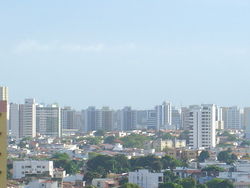
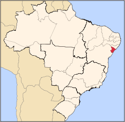
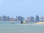
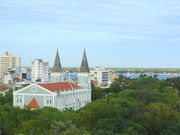
Aracaju is the capital of the State of Sergipe, Brazil, located in the northeastern part of the country, about 350 km (217 mi) north of Salvador. It has a population of circa 505,286 inhabitants, which represents approximately 33% of the state population. The coast of Aracaju has many unspoiled beaches, such as the ones in Santa Luzia Island, and urban beaches, such as the Atalaia. These coastal neighborhoods include playgrounds, squares, football, volleyball, and basketball fields, residential buildings, bars, nightclubs, restaurants, banks and hotels.
Aracaju, one of the first cities to be planned in Brazil, was built with the intention of becoming the state capital. Founded in 1855, as the capital of Sergipe.
The new Aracaju International Airport connects Aracaju with many Brazilian cities and also operates some international flights from Montevideo, Uruguay.
The city is home to the Federal University of Sergipe.[1]
Contents |
History
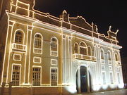
Although the first contact of the Portuguese in Sergipe was here, the first and most important city of that place which would be a province in the future was São Cristóvão (Saint Christopher), which became a city in 1590 and remained capital of Sergipe from 1823 to 1855. In the mid-nineteenth century, there was a sudden vogue for purpose-built harbour and administrative centres, and the core of modern Aracaju was constructed overnight, becoming the province capital in 1855, and after 1889 the state capital. In 1910, the city was made the seat of the Roman Catholic Archdiocese of Aracaju.
Unlike the other Brazilian capitals planned and built in the nineteenth century, Aracaju is known throughout the country for its modern looks, some festivals and pre-carnival feast. Oil wealth, sugar cane, and more recently tourism continue to stimulate its growing economy. Colonial towns of Laranjeiras and São Cristóvão are only a short bus ride away (Adapted from The Rough Guide to Brazil (2000), UK).
Geography
Climate
| Climate data for Aracaju | |||||||||||||
|---|---|---|---|---|---|---|---|---|---|---|---|---|---|
| Month | Jan | Feb | Mar | Apr | May | Jun | Jul | Aug | Sep | Oct | Nov | Dec | Year |
| Record high °C (°F) | 35 (95) |
34 (93) |
36 (97) |
32 (90) |
36 (97) |
32 (90) |
33 (91) |
30 (86) |
32 (90) |
35 (95) |
31 (88) |
35 (95) |
36 (97) |
| Average high °C (°F) | 30 (86) |
30 (86) |
30 (86) |
30 (86) |
29 (84) |
28 (82) |
27 (81) |
27 (81) |
27 (81) |
28 (82) |
29 (84) |
29 (84) |
28 (82) |
| Daily mean °C (°F) | 27 (81) |
28 (82) |
27 (81) |
27 (81) |
26 (79) |
26 (79) |
25 (77) |
25 (77) |
26 (79) |
26 (79) |
27 (81) |
27 (81) |
26 (79) |
| Average low °C (°F) | 25 (77) |
25 (77) |
25 (77) |
25 (77) |
24 (75) |
23 (73) |
22 (72) |
22 (72) |
23 (73) |
24 (75) |
25 (77) |
25 (77) |
24 (75) |
| Record low °C (°F) | 21 (70) |
21 (70) |
21 (70) |
21 (70) |
21 (70) |
18 (64) |
17 (63) |
15 (59) |
18 (64) |
18 (64) |
21 (70) |
21 (70) |
15 (59) |
| Source: Weatherbase | |||||||||||||
Aracaju has a typical tropical climate, with warm to hot temperatures and high relative humidity throughout the year; however, these conditions are relieved by a near absence of extreme temperatures and pleasant trade winds blowing from the ocean. January is the warmest month, with mean maxima of 32 °C (89.6 °F) and minima of 22 °C (71.6 °F) and more sun; July experiences the coolest temperatures, with mean maxima of 27 °C (80.6 °F) and minima of 17°C (62.6 °F) and more rain.
Vegetation
Aracaju has a tropical forest. Rainforests are characterized by high rainfall, with minimum normal annual rainfall between 2,000 mm (about 78 inches or 2 meters) and 1,700 mm (about 67 inches). The soil can be poor because high rainfall tends to leach out soluble nutrients.
Economy
The economy is based on services, industry and tourism.
The GDP for the city was R$ 5,021,660,000 (2005).[2]
Education
Portuguese is the official national language, and thus the primary language taught in schools, with English and Spanish also part of the official high school curriculum.
Educational institutions
- Universidade Federal de Sergipe (UFS) (Federal University of Sergipe);
- Universidade Tiradentes (Unit) (Tiradentes University);
- Faculdade São Luís (FSL) (São Luís College);
- Sociedade de Ensino Superior de Sergipe;
- and many others.
Culture
Museum
Museu do Artesanato, Museu do Instituto Histórico e Geográfico de Sergipe, Museu do Homem Sergipano, Museu Memorial de Sergipe, Museu de Antropologia, Museu de Arte Bélica da Polícia Militar de Sergipe and Museu de Arte e História Rosa Faria.
Library
Arquivo Público Estadual de Sergipe, Biblioteca da FANESE and Biblioteca Pública Epiphâneo Dórea.
Movies
Movie theaters in the Jardins Mall and Riomar Mall(Cinemark).
Infrastructure
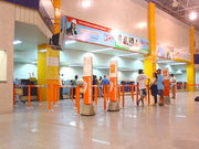
International Airport
The city is served by the Santa Maria Airport. It began operating on 30 October 1952 with a single 1200m runway, though it did not have an access road until 1958. In 1961, the runway was extended to 1500m and a terminal of passengers was built in 1962. In February 1975 the airport administration was undertaken by Infraero.
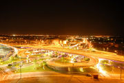
Highways
Aracaju is connected to the major cities of Brazil by BR-235 and BR-101 federal highways.
Sister cities
Social problems
Main article: Crime in Brazil and Social issues in Brazil
Images
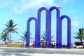 Arcos Square. |
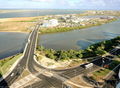 Rio-Mar bridge. |
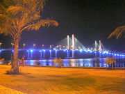 Aracaju bridge. |
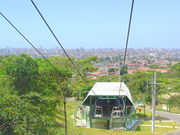 Aracaju aerial tramway. |
References
- ↑ http://www.ufs.br
- ↑ (in Portuguese) (PDF) GDP. Aracaju, Brazil: IBGE. 2005. ISBN 85-240-3919-1. http://www.ibge.gov.br/home/estatistica/economia/pibmunicipios/2005/tab01.pdf. Retrieved 2007-07-18.
External links
|
||||||||||||||||||||||||||||||||||||||
|
||||||||||||||||||||||||||||||||
|
||||||||||||||||||||
|
|||||||||||