Avarua

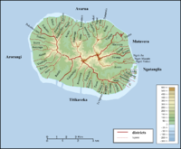
Avarua is a town and district in the north of Rarotonga Island. It is equivalent to Te-au-o-tonga, one of three vaka (traditional tribal areas of Rarotonga) and had its own local government headed by a mayoress until its legal abolishment in February 2008. Avarua is the national capital of the Cook Islands. The downtown area is located at at sea level, below the towering peaks of Rarotonga (altitude 208 m or 682 ft). The town has several supermarkets, two banks, several restaurants and other shops specializing in the sale of black pearls and other handicrafts. The town's open air market is on Saturday, where you can find everything from brightly coloured pare'u (wrap around dresses), to flower garlands, fresh fish and tropical fruits. The town is served by Rarotonga International Airport (IATA Airport Code: RAR). The population of Avarua District is 5,445 (census of 2006) [1], who mainly make their living from tourism, trade, fishing and agriculture. The one main road in Avarua is Ara Maire Nui, usually referred to as Marine Drive or Main Street, which turns into the island-circling ring road Ara Tapu at both ends of town.
Avarua is subdivided in to 18 tapere (out of 54 for Rarotonga), listed from west to east:
- Pokoinu
- Nikao (seat of Cook Islands parliament)
- Puapuautu
- Areanu
- Kaikaveka
- Atupa
- Avatiu (commercial port)
- Ruatonga
- Tutakimoa
- Tauae (inward from Tutakimoa, the only tapere without coast)
- Takuvaine (downtown Avarua, seat of Cook Islands government, with Avarua fishing harbour)
- Ngatipa
- Vaikai
- Tapae-I-Uta
- Pue
- Punamaia
- Kiikii
- Tupapa
Census figures are not available on the tapere level, but only for so-called Census-Areas [2], also listed from west to east [3]
- Nikao-Panama 1373 (tapere Pokoinu, Nikao, Puapuautu)
- Avatiu-Ruatonga 951 (tapere Areanu, Kaikaveka, Atupa, Avatiu, Ruatonga)
- Tutakimoa-Teotue 314 (tapere Tutakimoa)
- Takuvaine-Parekura 786 (tapere Tauae, Takuvaine)
- Tupapa-Maraerenga 531 (tapere Ngatipa, Vaikai)
- Pue-Matavera 1490 (tapere Tapae-I-Uta, Pue, Punamaia, Kiikii, Tupapa)
References
- ↑ http://epress.lib.uts.edu.au/ojs/index.php/cjlg/article/viewFile/766/755
- ↑ http://www.stats.gov.ck/Statistics/CensusSurveys/census06/Cen06-Tab6.pdf
- ↑ P.H. Curson: Population Change in the Cook Islands - The 1966 Population Census. In: New Zealand Geographer, Vol. 28, 1972, pp. 51-65, map p.52
External links
|
||||||||||||||||||||
| This Cook Islands location article is a stub. You can help Wikipedia by expanding it. |