Funafuti
| Funafuti | |
|---|---|
| — City — | |
 |
|
| Coordinates: | |
| Country | |
| Area | |
| - Total | 2.4 km2 (0.9 sq mi) |
| Population (2002) | |
| - Total | 4,492 |
| - Density | 1,871.67/km2 (4,847.6/sq mi) |
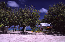
Funafuti is an atoll that forms the capital of the island nation of Tuvalu. It has a population of 4,492 (2002 Census), making it the most populated atoll in the country. It is a narrow sweep of land between 20 and 400 metres wide, encircling a large lagoon 18 km long and 14 km wide, with 275 sq km—by far the largest lagoon in Tuvalu. The land area of the 33 islets aggregates to 2.4 sq km, less than one percent of the total area of the atoll. There is an airstrip, hotel (Vaiaku Langi Hotel), and administrative buildings, as well as homes, constructed both in the traditional manner, out of palm fronds, and more recently out of cement blocks. The most prominent building on Funafuti atoll is the Church of Tuvalu. Other sites of interest are the remains of United States aircraft that crashed on Funafuti during World War II, when the airstrip was used by the U.S. forces to defend the Gilbert Islands and the Marshall Islands. The U.S. claimed Funafuti under the Guano Islands Act from the 1800s until a treaty of friendship was concluded in 1979, coming into effect in 1983.
The largest island is Fongafale. On this island, there are four villages, of which one is Vaiaku, where the Tuvalu's government is located. The capital of Tuvalu is sometimes given as Fongafale or Vaiaku, but the entire atoll of Funafuti is officially the capital.
Contents |
Villages on Funafuti
The individual villages of the atoll with population, according to the census of population 2002, by islet:
central Fongafale islet
- Fakaifou 1007
- Senala 589
- Alapi 1024
- Vaiaku 516
rest of Fongafale islet
including Tengako peninsula in the north
- Lofeagai 399
- Teone 540
- Tekavatoetoe 343
Funafala
- Funafala 22
Amatuku
- Amatuku 52
Funafuti Marine Conservation Area
In June 1996, the Funafuti Marine Conservation Area was established along the western rim of the reef, encompassing six islets. It has an area of 33 km², containing 20 percent of the reef area of Funafuti. The land area of the six islets in the conservation area is 8 ha (0.08 km²). The islets in the conservation area, from north to south, with estimated area in hectares:
- Tepuka Vilivili, 3
- Fualopa, 2
- Fuafatu, 0.2
- Vasafua, 0.5
- Fuakea, 1.5
- Tefala, 1
Islands in Funafuti
There are at least 33 islands in the atoll. The biggest is Fongafale, followed by Funafala. At least three islands are inhabited, which are Fongafale, the main island in the east, Funafala in the south, and Amatuku in the north.
- Amatuku
- Avalau
- Falaoigo
- Fale Fatu (or Falefatu)
- Fatato
- Fongafale
- Fuafatu
- Fuagea
- Fualefeke (or Fualifeke)
- Fualopa
- Funafala
- Funamanu
- Luamotu
- Mateika
- Motugie
- Motuloa
- Mulitefala
- Nukusavalevale
- Papa Elise (or Funangongo)
- Pukasavilivili
- Te Afuafou
- Te Afualiku
- Tefala
- Telele
- Tengako (peninsula of the island of Fongafale)
- Tengasu
- Tepuka
- Tepuka Vili Vili
- Tutanga
- Vasafua
- And at least 5 other islands
Passages of Funafuti Atoll
The atoll has several passages with varying degrees of navigability that lead in to the lagoon. The passes are listed clockwise, starting south of Fongafale islet. The first two clearly separate the southern part of Funafuti Atoll from the rest.
- Te Ava Pua Pua, with a least depth of 12.7 metres, between the islets of Funamanu to the north and Fale Fatu to the south, in the southeast, separating the southern part of the atoll in the east
- Te Ava Fuagea, also known as Ava Amelia is a deep and narrow passage on the southwestern side of the atoll, 18.3 metres deep and 160 metres wide, separating the southern part of the atoll in the west, south of passage Te Ava Papa and the still more northerly islet of Fuafatu, and north of the islet of Vasafua
- Te Ava Papa (just north of Te Ava Fuagea)
- Te Ava Kum Kum is in the middle of the western rim, south of Te Ava Tepuka Vili, between the islets of Tepuka Vili Vili to the north and Fualopa immediately south
- Te Ava Tepuka Vili, a deep and narrow channel, between the islets of Tepuka to the north, and Tepuka Vili Vili to the south
- Te Ava Tepuka and Te Avua Sari are two neighbouring passes in the northeast, between the islets of Te Afualiku to the northeast and Tepuka to the southwest
- Te Ava i te Lape is the favoured entrance into the lagon, although it has a depth of only 5.8 metres, and a width of barely 500 metres. It is in the north, between the islets of Pava to the east and Te Afualiku to the west.
Lagoon
The lagoon (TeNamo in Tuvaluan) of Funafuti atoll has a north-south length of 24.5 km, and east-west 17,5 km, with an area of 275 km², making it by far the largest lagoon of Tuvalu. It is up to 52 metres deep, but has several submerged rocks and reefs that are coming as close as 6 metres to the surface. [1]
Transportation
Funafuti International Airport is located here.
See also
- List of Guano Island claims
External links
|
|||||||||||||||||||||||||
|
||||||||||||||||||||