Nukuʻalofa
| Nukuʻalofa | |
|---|---|
 |
|
 Nukuʻalofa
|
|
| Coordinates: | |
| Country | |
| Island | Tongatapu |
| Population (1996) | |
| - Total | 22,400 |
| Time zone | – (UTC+13) |
| - Summer (DST) | – (UTC+13) |
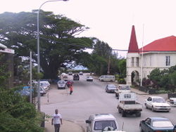
Nukuʻalofa, the capital of the Kingdom of Tonga. It is located on the north coast of the island of Tongatapu, in the southern most island group of Tonga.
Contents |
Myths of Nukuʻalofa (Land of Love)
In the Tongan myth of the origin of Nukuʻalofa, it was said that the meaning of Nukuʻalofa is: nuku meaning land, ʻalofa meaning love.
The name is said to have originated when Moʻungatonga, the 6th Tuʻi Haʻatakalaua (King who governs the daily business of Tonga on behalf of the Tuʻi Tonga or Sacred King of Tonga) sent his youngest son, Ngata (later to be 1st Tuʻi Kanokupolu) as governor to Hihifo (Western side of Tongatapu). It was a difficult decision for Ngata as the Tu’i Tonga and Tu’i Ha’atakalaua have been unable to control Hihifo. Ngata had many reasons to fear for his life as his predecessors had been killed by the chiefs and people of Hihifo.
When Ngata left Muʻa, the old capital and residence of the Tuʻi Tonga and Tuʻi Ha'atakalaua, he was escorted by Nuku (an uncle) and Niukapu (an older cousin), chiefly relatives of his father. They sailed their canoes with all their followers from Muʻa and debated abandoning Tonga and sailing directly to Samoa, the homeland of Ngata’s mother. It was decided not to abandon Tonga, but to pull their canoes up into the swamp area halfway between Muʻa and Hihifo in order to plan and prepare for their landing at Hihifo.
Ngata, Nuku and Niukapu decided to wrap their combined bodies under a large mat and land in Hihifo, giving the impression of a large man with three heads. This is the origin of the ʻUlutolu (Three Head Story) and of the Haʻa Tuʻi Kanokupolu, third lineage King of Tonga. They named the swampy area as Nuku (Land) ʻAlofa (Love) or the Land of Love, thus Nukuʻalofa started as an uninhabited swamp.
First Record of Nukuʻalofa by Captain Cook 1777
On 10 June 1777 Captain Cook wrote of his arrival at their anchorage place. His description of the place confirmed, with his map, that this was the bay of Nukuʻalofa.
At length, about two in the afternoon, we arrived at our intended station. It was a very snug place, formed by the shore of Tongataboo on the South East, and two small islands on the East and North East. Here we anchored in ten fathoms water, over a bottom of oozy sand; distant from the shore one-third of a mile."[1]
Capt Cook never mentioned the name Nukuʻalofa in this voyages, but he mentioned the island of Pangaimodoo (Pangaimotu) which was to the east of his anchorage position. Captain Cook also wrote that he travelled by canoes to visit Mooa (Muʻa) where Paulaho and other great men lived.
The house that Paulaho provided was on the beach a third of a mile from the ship. Reference to his map shows that he must have landed and stayed in the Siesia area, the eastern part of modern Nukuʻalofa. Captt Cook also draft the first map of the bay of Nuku'alofa.
Map from Captain James Cook, A Voyage to the Pacific Ocean, 1783, p 277
George Vason (Veeson) and the London Missionary Society 1797
The first written record for Nuku'alofa is stated in the first dedicated book for Tonga by George Vason which was published in 1810. George Vason was a Missionary from the London Missionary Society who arrived in Tonga in 1797,nineteen years after Capt Cook departed the bay of Nuku'alofa. George Vason wrote of their arrival in 1797 that:
"Before we could well come to an anchor, the ship was surrounded by the natives, who flocked to us from every adjacent Island. The place, before which we anchored, was called Noogollefa: it was near an Island, named Bonghy-moddoo; on which former navigators pitched their tents, as a convenient spot, on account of its separation from the main Island, to preserve themselves from being two much incommoded by the natives."[2]
That was the first mention of Nuku'alofa spelled as Noogoollefa and Pangaimotu was spelled as Bongy-Moddoo by George Vason since Tongan writing and alphapet would be developed later in 1826-27.
William Mariner (Toki Ukamea) 1806
The second oldest book dedicated to Tonga was by William Mariner, adopted son of Finau 'Ulukalala which was published in 1817. Mariner descriped his experiences durng the years he was the adopted son of 'Ulukalala (1806–1810).
Mr Mariner descrriped the civil war and the siege of the Fort of Nuku'alofa and after eleven years, the Fort of Nuku'alofa felled to 'Ulukalala and his warriors who used the canons he sieged from the Port au Prince. Here is a description of the Fort of Nuku'alofa as written by Mr Mariner:
Finow and his attendants having returned on board, the whole fleet proceeded to a neighbouring fortress called Nioocalofa, the strongest, though not the largest, in the whole island. As it will be proper to understand the usual form and construction of these Tonga fortresses, we shall give a general description of them taking that of Nioocalofa as a model for the rest. The fortress of Nioocalofa is situated on the west coast of the island, about one hundred yards distant from the water's edge, and occupies about four or five acres of ground. It consists, in the first place, of a strong wall or fencing of reeds, something like wicker-work, supported on the inside by upright posts, from six to nine inches in diameter, and situated a foot and a half distant from each other; to which the reed-work is firmly lashed by tough sinnet, made of the husk of the cocoa-nut. This fencing is about nine feet in height, the posts rising about a foot higher: it has four large entrances, as well as several small ones, secured on the inside by horizontal sliding pieces, made of the wood of the cocoa-nut tree. Over each door, as well as at other places, are erected platforms even with the top of the fencing, supported chiefly on the inside, but projecting forward to the extent of two or three feet: these platforms are about nine feet square, and situated fifteen yards distant from each other; and as they are intended for the men to stand on, to shoot arrows, or throw down large stones, they are also defended in front, and half way on each side, by a reed-work six feet high, with an opening in front, and others on either hand, for the greater convenience of throwing spears, &c. The lower fencing has also openings for a similar purpose. On the outside is a ditch of nearly twelve feet deep, and as much broad; which, at a little distance, is encompassed by another fencing similar to the first, with platforms, &c. on the outside of which there is a second ditch. The earth dug out of these ditches forms a bank on each side, serving to deepen them. Opposite each large doorway, there is no ditch dug. The inner and outer fences are ornamented profusely with white shells. Some of these fortifications are square, others round. That of Nioocalofa was round.[3]
Arrival of Christianity in Nuku’alofa 1826
The third attempt of christian missionaries were recorded in April 1826 when two Tahitian London Missionaries were detained by Tupou the chief of Nuku'alofa. While the spelling used by this source is in modern forms, the Tongan alphapet was not invented after the arrival of the Methodist Missionaries in June 1826.
In March 1826, the four men left Tahiti in the Minerva, their destination Fiji. But at Nuku’alofa, Tonga, their plans were disrupted by the high chief Tupou (Aleamotu’a). From Davies’ perspective the Tahitian were placed under detention at Tongatapu: “The chief called Tupou would not let them proceed. He had been himself a resident in Lageba and calls himself the friend of Tuineau, the chief of Lageba and as such he took possession of the present intended for the Fijian chief.[4]
The arrival of the Methodist Missionaries, in Nuku'alofa in 1827 of Mr Turner and Mr Cross reinforced the Christian faith. The persecution suffered by Christian in Hihifo and Hahake forces a lot of people to seek refugees in Nuku'alofa. With the encouragement of Tupou the King at Nuku'alofa, this was the beginning of the expanding of Nuku'alofa to become the major center of Christianity in Tonga.
On June 1, 1828, King Tubou threw aside all hesitation by rejoining the public worship of Jehovah. A great throng gathered to Nukualofa for the occasion; the heathen in the rest of the island remained quiescent. Many families came to reside in Tubou's town, to be near the Christian teachers and to escape persecution. Nukualofa grew in strength and importance.[5]
The final phase of the arrival of Christianity in Tonga was the arrival of Father Chevron or Patele Sevelo in 1842, where he wrote that:
“Le Vicaire apostolique n'hésita donc pas à descendre dans la grande île avec le P. Chevron; et, comme l'usage le demandait, il alla d'abord à Noukou-Alofa, où, sous le titre de Toui-Kano-Kopolou, résidait celui qu'on regardait comme le chef de la féodalité tongienne, sous la haute suzeraineté du Toui-Tonga. Le titulaire du moment était Aléa-Matoua, appelé Sosaïa depuis son baptême wesleyen ; son nom a été prononcé dans l'exposé de la guerre de Péa.”[6]
"Patele Sevelo wrote that in 1842, he arrived in Nuku'alofa and met the Tu'i Kanokupolu Aleamotu'a who was baptised by the Wesleyan as Sosaia."
In conclusion, these arrival turned Nuku'alofa from a small village and fort into the center of Tonga during the arrival of Christianity. The welcome by Aleamotu'a of all persecuted Christians turn Nuku'alofa into the safe heaven of Christianity and the village of Nuku'alofa grew in size and influence in Tongan politics.
From the earliest record for Nuku'alofa, the early writer always refer to the settlement as Noogollefa (1797), Nioocalofa (1806), Nukualofa (1826 by Methodist) and Noukou-Alofa (1842 by Catholic Priest). There was no other mention of any other name of the settlement but only of the settlement of Nuku'alofa.
Nuku’alofa the Capital of the Kingdom of Tonga 1875
It was after the Declaration of the Constitution of Tonga in 1875, that formalised Nuku'alofa as the Capital of Tonga. King George Taufa'ahau Tupou I declared the Constitution of Tonga on the 4th November 1875, in Nuku'alofa.
The Constitution also stated in Article 38 of the Constitution that Parliament will meet in Nuku'alofa except in time of war.
In Article 52 of the Constitution, it is stated that: "Each member of the Cabinet shall have an office in Nuku'alofa the capital of the Kingdom and he shall satisfy himself that all the subordinates in his department faithfully perform their duties. And the Government shall build or rent offices suitable for the work of each minister." This is the first mention of Nuku'alofa as the Capital of Tonga.
Since Nuku'alofa have been expanding since it became the center of Christianity in the 1800s, it became essential that it was reorganised for effective administration of the capital.
The reorganisation of Nuku'alofa divided up Nuku'alofa into three major district area:
a. Kolomotu'a: Kolo meaning town or settlement, motu'a meaning old. Thus Kolomotu'a refer to the old settlement of Nuku'alofa, thus it mean, Kolo motu'a 'o Nuku'alofa. This cover all the area of the old Fort of Nuku'alofa and all the western area where it was the traditional settlement of the Tu'i Kanokupolu from Mumui the 13th Tu'i Kanokupolu to Aleamotu'a the 18th Tu'i Kanokupolu.
b. Kolofo'ou: Kolo meaning town or settlement, fo'ou meaning new. Thus Kolofo'ou refer to all the new settlement or expanding of Nuku'alofa, thus it meanKolo fo'ou 'o Nuku'alofa. This area started from the old Fort of Nuku'alofa to all the eastern side, including the home of King George Taufa'ahau Tupou I, which was called Loto'a and all the new settlement and seat of govenment of Tonga.
c. Ma'ufanga: is the last part of Nuku'alofa on the eastern side of Nuku'alofa. Ma'ufanga was an old village of the Ha'a Takalaua which is the Estate of the Chief Fakafanua. It was mention by Ceorge Vason that Ma'ufanga was a refugees area during the civil war and where people can seek refugees in time of hardship. Ma'ufanga is the area facing Pangaimotu where Captain Cook mention that he anchored of Pangaimotu and Paulaho build him a house on the beach about a third of a mile from the ship.
While Nuku'alofa have smaller suburbs with different names and with different claimed histories, the three district of Nuku'alofa is mention above where they are administered to the current days.
Government
There are district officers (ʻofisa vahe) and town officers (ʻofisa kolo), as in all villages of Tonga. Their main task is to disseminate the orders of the government to the people. Vacancies for town officer positions are usually advertised in the local newspapers. Services such as police, fire brigade, and hospitals are arranged by the national government.
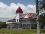
The national government is based in Nukuʻalofa. The parliament of Tonga meets there, and the Royal Palace is located near the city. The city is home to the embassies of foreign countries.
Economy

Nukuʻalofa is the economic hub of the country. The former Royal Tongan Airlines had its head office in the Royco Building in Nukuʻalofa.[7][8]
Tonga's current airline, Peau Vava'u, operates from Fuaʻamotu International Airport, near Nukuʻalofa.
The city has markets and a central business district. Much of the central business district was destroyed during the 2006 Nuku'alofa riots, but it is being rebuilt.
Transport
Nukuʻalofa is the central hub for transport in Tonga.
Buses arrive and depart from the central bus station along Vuna Road close to the centre of town. Bus services are privately operated, and their drivers are free to set their own schedules. Fares are fixed by the government, with reduced rates for school children. The buses are usually filled to capacity. In addition, some schools and large hotels provide their own buses.

There are numerous taxis, also privately owned. Many people who own a car earn extra money by providing taxi services in their spare time. Taxi fares are also set by the government. Most families have their own car; few residents ride bicycles. There are no railways or trams in Tonga.
Nukuʻalofa harbour is the only deep-water harbour of the island, which determined its selection as the site for the capital. For many years Vuna Wharf was the international harbour until it was destroyed by an earthquake in 1977. A new, much larger wharf was built towards Maʻufanga, named after Queen Sālote. Between these two wharves is the wharf numbered '42', used by fishermen and inter-island ferries wharf. It is the central hub for boats to the outer islands. There are usually two boats to ʻEua each day, and two to Haʻapai and Vavaʻu each week. In addition to these regular services by shipping companies, private boat owners provide less regular services to smaller islands such as Nomuka and ʻEueiki.
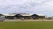
Air transport is provided by Fuaʻamotu International Airport on the south side of Tongatapu, 35 kilometres from Nukuʻalofa.
Sister cities
Endnote
- ↑ Cook, 1783, pg 277
- ↑ Vason,1810,pg 68
- ↑ Martin,1817,pg 99?
- ↑ Munro and Thornley,pg 94
- ↑ Findlay and Holdsworth, 1921, pg 289-290
- ↑ Monfat,1893,pg183
- ↑ "World Airline Directory." Flight International. 30 March - 5 April 2004. 61.
- ↑ "Contact Information." Royal Tongan Airlines. 6 June 2004. Retrieved on 23 October 2009.
References
- Vason G, AN authentic of narrative of four years residence at one of the Friendly Islands,1810
- Martin J, An account of the natives of the Tonga Islands, in the south pacific ocean. with an original grammer and vocabulary of their language. Compiled and arranged from the extensive communication of Mr William Mariner, several years resident in those islands, 1817
- Munro and Thornley, The convant makers: Islanders missionaries in the Pacific,1996.
- Findlay and Holdworth, History of the Wesleyan Methodist Missionary Society Vol III, 1921
|
||||||||||||||||||||