Carmarthenshire
 |
|
| Geography | |
| Area - Total - % Water |
Ranked 3rd 2,395 km² ? % |
|---|---|
| County Town | Carmarthen |
| Largest Town | Llanelli |
| ISO 3166-2 | GB-CMN |
| ONS code | 00NU |
| Demographics | |
| Population: - Total (2007 est.) - Density |
Ranked 4th 179,500 Ranked 18th 75 / km² |
| Ethnicity | 99.4% White |
| Welsh language - Any skills |
Ranked 3rd 63.6% |
| Politics | |
 Carmarthenshire County Council http://www.carmarthenshire.gov.uk/ |
|
| Control | NOC (Independent-led coalition) |
| MPs |
|
| AMs | |
| MEPs | Wales |
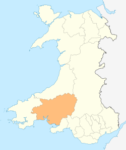
Carmarthenshire (Welsh: Sir Gaerfyrddin or Sir Gâr) is a unitary authority in the south west of Wales and one of thirteen historic counties. Its three largest towns are Carmarthen, Llanelli and Ammanford. The county town and administrative centre of Carmarthenshire is Carmarthen and the most populous settlement is the area in and around the town of Llanelli. Carmarthenshire has its early roots in the region formerly known as Ystrad Tywi (Vale of [the river] Tywi) and part of the Principality of Deheubarth during the High Middle Ages, with the court at Dinefwr. Following the Edwardian Conquest of Wales, the region was reorganized by the Statute of Rhuddlan in 1284 into Carmarthenshire.
With its fertile land and agricultural produce, Carmarthenshire is known as the "Garden of Wales".[1]
Contents |
Geography

The county is bounded to the north by Ceredigion, to the east by Powys, Neath Port Talbot and Swansea, to the south by the Bristol Channel and to the west by Pembrokeshire. Carmarthenshire has a population of approximately 170,000, 55.1% of whom are Welsh speakers. The surface generally is upland and mountainous. Fforest Fawr and Black Mountain extend into the east of the county and the Cambrian Mountains into the north. The south coast contains many fishing villages and sandy beaches. The highest point is the Fan Brycheiniog, 2,525 feet (770 m). Carmarthenshire is the largest historic county by area in Wales.
It is drained by several important rivers, especially the Towy, which flows into the Bristol Channel and its several tributaries, such as the River Cothi. The Towy is the longest river flowing entirely within Wales, and is noted for its trout and salmon fishing. Other ivers include the Loughor (which forms the eastern boundary with Glamorgan), and the Gwendraeth Fawr.
Principal towns are Ammanford, Burry Port, Carmarthen, Kidwelly, Llanelli, Llandeilo, Newcastle Emlyn and Llandovery, Sandy, St. Clears, Whitland, Pendine. The principal industries are agriculture, forestry, fishing and tourism. Although Llanelli is by far the larger town in the county, the county town remains in Carmarthen, mainly due to its central location.
Government
Carmarthenshire became an administrative county with a county council taking over functions from the Quarter Sessions under the Local Government Act 1888. Under the Local Government Act 1972, the administrative county of Carmarthenshire was abolished on 1 April 1974, and the area of Carmarthenshire became three districts within the new county of Dyfed : Carmarthen, Dinefwr and Llanelli. Under the Local Government (Wales) Act 1994, Dyfed was abolished on 1 April 1996, and the three districts united to form a unitary authority, which had the same boundaries as the original Carmarthenshire. In 2003, following a local campaign, the Clunderwen community council area was transferred to Pembrokeshire.
Places of interest
| Carmarthenshire | |
| Geography | |
| 1831 area | 606,331-acre (2,453.73 km2) |
| HQ | Carmarthen |
| Chapman code | CMN |
| History | |
| Succeeded by | Dyfed |
| Demography | |
|---|---|
| 1831 population - 1831 density |
100,740[2] 0.2/acre |
| Politics | |
| Governance | Carmarthenshire County Council (1889-1974) |
Historical places
Geography
|
Museums
Heritage railways
Sports venues
|
See also
- List of places in Carmarthenshire for an alphabetical list of towns and villages.
- People from Carmarthenshire for a list of notable people from the county.
References
- ↑ Visit Britain - Carmarthenshire
- ↑ Vision of Britain - 1831 Census
External links
- Carmarthenshire county council
- Carmarthenshire Official site from South West Wales Tourist Board
- Genuki: Research sources for Carmarthenshire
- Carmarthenshire at the Open Directory Project
|
||||||||||||||||
|
|||||
|
||||||||||||||||||||||||||||||||||
|
|||||||||||||||||||||||||