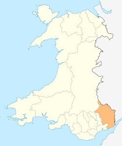
Monmouthshire
 |
|
| Geography | |
| Area - Total - % Water |
Ranked 7th 850 km2 ? % |
|---|---|
| Admin HQ | Cwmbran |
| ISO 3166-2 | GB-MON |
| ONS code | 00PP |
| Demographics | |
| Population: - Total (2007 est.) - Density |
Ranked 18th 88,200 Ranked 15th 104 / km2 |
| Ethnicity | 97.5% White |
| Welsh language - Any skills |
Ranked 22nd 12.9% |
| MP |
|
| AM |
|
Monmouthshire (Welsh: Sir Fynwy) is a county in south east Wales. The name derives from the historic county of Monmouthshire which covered a larger area.
Contents |
Historic county
The historic county of Monmouthshire was formed from the Welsh Marches by the Laws in Wales Act 1535. It bordered Gloucestershire to the east, Herefordshire to the northeast, Brecknockshire to the north, and Glamorgan to the west. Between the 16th and 20th centuries there was some ambiguity as to whether the county was part of Wales or England, but since 1974 the area has been placed definitively in Wales. The eastern and southern boundaries of the historic county and the current principal area are the same, along the River Wye and Severn estuary; however, the western two-fifths of the historic county are now administered by the other unitary authorities of Blaenau Gwent, Torfaen, Caerphilly and Newport. The administrative county of Monmouthshire, and associated lieutenancy were abolished in 1974 under the Local Government Act 1972. The area largely became part of the new local government and ceremonial county of Gwent.
Principal area
The current unitary authority was created on 1 April 1996 as a successor to the district of Monmouth along with the Llanelly community from Blaenau Gwent, both of which were districts of Gwent. The use of the name "Monmouthshire" rather than "Monmouth" for the area was mildly controversial, being supported by the MP for Monmouth, Roger Evans, but being opposed by Paul Murphy, MP for Torfaen (inside the historic county of Monmouthshire but being reconstituted as a separate unitary authority). [1] By area it covers some 60% of the historic county, but only 20% of the population. The council's administrative headquarters are at the former Gwent County Hall at Croesyceiliog, Cwmbran — outside of its own jurisdiction in the neighbouring borough of Torfaen. It is the only principal area in Wales administered from outside its boundaries; however there are plans to move the council headquarters to offices at Coleg Gwent, Usk.[2] In comparison to the pre-1974 areas it covers:
- the former boroughs of Abergavenny and Monmouth
- the former urban districts of Chepstow and Usk
- the former rural districts of Abergavenny, Chepstow and Monmouth
- the former rural district of Pontypool, except the community of Llanfrechfa Lower
- the parish of Llanelly from the former Crickhowell Rural District in Brecknockshire
Places of interest
- See List of places in Monmouthshire for a list of settlements in the principal area.
- Chepstow Castle [1]
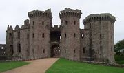
- Raglan Castle [2]
- Monmouth [3]
- Trellech [4]
- Abergavenny Castle [5]
- Wye Valley [6]
- Black Mountains [7]
- Brecon Beacons National Park [8]
- White Castle [9]
- Skenfrith Castle [10]
- Grosmont Castle [11]
- Three Castles Walk [12]
- Offa's Dyke [13]
- Llanthony Priory [14]
- Tintern Abbey [15]
- Usk [16]
- Usk Valley Walk [17]
- Abergavenny [18]
- Monmouthshire & Brecon Canal [19]
- Marches Way [20]
- Monnow Valley Walk [21]
- Caldicot Castle [22]
- The Kymin [23]
References
External links
- Monmouthshire County Council
- Monmouthshire at the Open Directory Project
- The Original Monmouthshire website Monmouthshire.co.uk
- BBC Wales on Monmouthshire
- Genuki National Gazetteer of 1868
|
||||||||||||||||||||||||||||||||||
|
|||||||||||||
|
||||||||||||||||||||