Powys
- This article is about the county in Wales. For other uses, see Kingdom of Powys and Powys (surname).
 |
|
| Geography | |
| Area - Total - % Water |
Ranked 1st 5,196 km² ? % |
|---|---|
| Admin HQ | Llandrindod Wells |
| ISO 3166-2 | GB-POW |
| ONS code | 00NN |
| Demographics | |
| Population: - (2007 est.) - Density |
Ranked 10th 132,000 Ranked 22nd 25 / km² |
| Ethnicity | 99.3% White |
| Welsh language - Any skills |
Ranked 7th 30.1% |
| Politics | |
 Powys Council http://www.powys.gov.uk/ |
|
| Control | Independent |
| MPs |
|
| AMs |
|
| MEPs |
|
Powys (usually pronounced /ˈpaʊ.ɪs/[1] in English; in Welsh: [ˈpowɪs]) is a local-government county and preserved county in Wales.
Contents |
Geography
- See the list of places in Powys for all towns and villages in Powys.
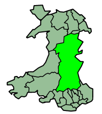
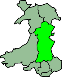
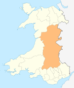
Powys covers the historic counties of Montgomeryshire and Radnorshire, most of Brecknockshire, and a small part of Denbighshire — an area of 5,196 km², making it the largest county in Wales by land area.
It is bounded to the north by Gwynedd, Denbighshire and Wrexham; to the west by Ceredigion and Carmarthenshire; to the east by Shropshire and Herefordshire; and to the south by Rhondda Cynon Taf, Merthyr Tydfil, Caerphilly, Blaenau Gwent, Monmouthshire and Neath Port Talbot.
Most of Powys is mountainous, with north-south transportation by car being difficult.
The majority of the Powys population is made up of small villages and towns. The largest is Newtown, with a population of 12,783 (2001).
Just under a third of the residents have Welsh linguistic skills and Welsh speakers are concentrated mainly in the rural areas both in and around Machynlleth, Llanfyllin and Llanrhaeadr-ym-Mochnant (where William Morgan first translated the whole Bible into Welsh in 1588) in Montgomeryshire (Welsh: Sir Drefaldwyn), and the industrial area of Ystradgynlais in the extreme south-west of Brecknockshire (Welsh: Sir Frycheiniog). Radnorshire (Welsh: Sir Faesyfed) was almost completely Anglicised by the end of the 18th century.
For a map of the current distribution of Welsh speakers see the website of bwrdd-yr-iaith/The Welsh Language Board
History
This area is named after the older Welsh/British Kingdom of Powys, which occupied the northern two thirds of the area as well as lands now in England, and came to an end when it was occupied by Llywelyn ap Gruffydd of Gwynedd during the 1260s.
In December 2007 Powys was awarded Fairtrade County status by the Fairtrade Foundation[2]
Heraldry
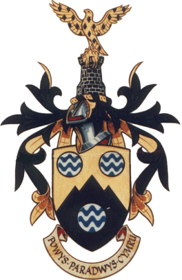
The gold in the county coat of arms (see right) symbolises the wealth of the area. Black for both mining and the Black Mountains. The fountain is a medieval heraldic charge, always shown as a roundel barry wavy Argent and Azure. It represents water and, therefore, both refers to the water catchment area and the rivers and lakes. The arms, therefore, contain references to the hills and mountains, rivers and lakes, water supply and industry.
The crest continues the colouring of the arms. A tower has been used in preference to a mural crown, which alludes to the county's military history and remains. From the tower rises a red kite, a bird almost extinct elsewhere in Britain, but thriving here. The bird is semy of black lozenges for the former coal mining industry, while the golden fleece it carries is a reference to the importance of sheep rearing in Powys [3]).
The county motto is, Powys - the paradise of Wales (Welsh: Powys Paradwys Cymru) .
Government
Powys was originally created on 1 April 1974 under the Local Government Act 1972, and originally had Montgomery and Radnor and Brecknock as districts under it, which were based directly on the former administrative counties.
On 1 April 1996, the districts were abolished, and Powys was reconstituted as a unitary authority, with a minor border adjustment in the north-east (specifically the addition of the communities of Llansilin and Llangedwyn from Glyndwr district in Clwyd, along with the movement of the border so that all of, and not as previously half of, Llanrhaeadr-ym-Mochnant was in Powys, all historically part of Denbighshire).
The first Lord Lieutenant of Powys was previously the Lord Lieutenant of Montgomeryshire. The Lord Lieutenant of Brecknockshire and Lord Lieutenant of Radnorshire were appointed as Lieutenants.
The present Lord Lieutenant is The Hon. Mrs Elizabeth Shân Legge-Bourke LVO of Crickhowell.
Quality of life
Recent research suggests that Powys is the happiest place in the UK[4], however, even the researchers said the numbers were not statistically significant[5].
Places of interest
Cave systems
- Ogof Agen Allwedd
- Ogof Craig a Ffynnon
- Ogof Ffynnon Ddu
- Ogof y Daren Cilau
Lakes, reservoirs and waterfalls
- The Elan Valley Reservoirs:
- Lake Vyrnwy
- Llangorse Lake [6].
- Llyn Clywedog
- Pistyll y Llyn - one of the highest waterfalls in Wales
- Pistyll Rhaeadr
- Water-breaks it-neck - waterfall in Radnorshire
Museums and exhibitions
- Brecknock Museum, Brecon,
- Centre for Alternative Technology, Machynlleth
- The Museum of Fiction, Llanerfyl
- Llandrindod Wells Museum
- Llanidloes Museum
- Newtown Textile Museum
- Powysland Museum, Welshpool
- The Judges Lodgings, Presteigne
- The Old Bell Museum, Montgomery
- The Robert Owen Museum, Newtown
Castles
- Dolforwyn Castle
- Montgomery Castle
- Powis Castle
- Tretower Castle
- Aberedw Castle
- Castell Du
Walks
- The Wye Valley Walk from Chepstow to Rhayader
- Offa's Dyke Path
- Glyndŵr's Way
- Severn Way
- Taff Trail
- The Sarn Sabrina circular walk from Llanidloes via the source of the River Severn (Welsh: Afon Hafren) in Hafren Forest, Plynlimon.[7]
Others
- The Black Mountains
- Brecon Beacons
- Y Gaer, Brecon Roman fort
- Welshpool and Llanfair Light Railway
- Radnor Forest
- The Welsh National Cycle Route
References
- ↑ POW-iss, with the vowels of "how" and "hiss"
- ↑ Sally Williams. "FairTrade Resource Network". http://www.fairtraderesource.org/2007/12/07/wales-ahead-in-bid-to-be-first-fairtrade-country/. Retrieved 3 July 2008.
- ↑ http://www.ngw.nl/int/gbr/p/powys.htm International Civic Heraldry site
- ↑ "BBC - "Britain's Happiest Places Mapped"". 28 August 2008. http://news.bbc.co.uk/1/hi/health/7584321.stm. Retrieved 28 August 2008.
- ↑ http://news.bbc.co.uk/2/hi/health/7584321.stm
- ↑ http://www.mikehollandphotographic.co.uk/photo_51647.html Langorse Lake at dawn
- ↑ "Llani Leisure". http://www.llanileisure.org.uk/Sarnsabrinaroutenarration. Retrieved 3 July 2008.
External links
- Powys at the Open Directory Project
- Powys County Council official site
- Powys Heritage
- Tourism in Powys
- Coleg Powys
- Clwyd-Powys Archaeological Trust
- Reducing the area's carbon footprint - Recycling and Composting in Powys
|
||||||||||||||||
|
||||||||||||||||||||||||||||||||||
|
|||||
|
||||||||||||||||