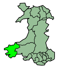
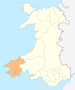
Pembrokeshire
 |
|
| Geography | |
| Area - Total - % Water |
Ranked 5th 1,590 km² ? % |
|---|---|
| Admin HQ | Haverfordwest |
| ISO 3166-2 | GB-PEM |
| ONS code | 00NS |
| Demographics | |
| Population: - (2007 est.) - Density |
Ranked 14th 117,900 Ranked 19th 74 / km² |
| Ethnicity | 99.2% White |
| Welsh language - Any skills |
Ranked 8th 29.4% |
| Politics | |
Pembrokeshire Council http://www.pembrokeshire.gov.uk/ |
|
| Control | Independent |
| MPs |
|
| AMs |
|
| MEPs | Wales |
Pembrokeshire (pronounced /ˈpɛmbrʊkʃɪər/, /ˈpɛmbrʊkʃər/, or /ˈpɛmbroʊkʃɪər/; Welsh: Sir Benfro) is a county in the southwest of Wales. Pembrokeshire was founded upon Dyfed until its conquest by the Normans in the late 11th century.
Contents |
Geography
Pembrokeshire is a maritime county, bordered by the sea on three sides, by Ceredigion to the north east and by Carmarthenshire to the east. Its economy relies heavily on tourism, but agriculture is still important, and petrochemical and liquid natural gas industries have been developed on the banks of the Cleddau Estuary.
Its population was 114,131 at the United Kingdom Census 2001.
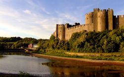
The administrative headquarters and historic county town is Haverfordwest and other settlements include Pembroke itself, Pembroke Dock, Milford Haven, Fishguard, Tenby, Saundersfoot, Narberth, Neyland and Newport. St David's, in the North west of the county, is the United Kingdom's smallest city.
The highest point of the county is at Foel Cwmcerwyn (1759 ft/536 m).
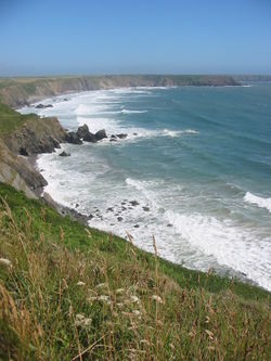
The county has a coastline comprising important seabird breeding sites and numerous bays and sandy beaches. Pembrokeshire boasts a predominantly coastal National Park known as the Pembrokeshire Coast National Park, of which includes a 186-mile walking trail known as the Pembrokeshire Coast Path. A large estuary and natural harbour at Milford Haven cuts deeply into the coast, formed by the confluence of the Western Cleddau (which goes through Haverfordwest), the Eastern Cleddau and rivers Cresswell and Carew. The estuary is bridged by the large Cleddau Bridge (toll bridge) which bears the A477 between Neyland and Pembroke Dock; upstream bridges are found crossing the Cleddau at Haverfordwest and Canaston.
Large bays are Newport Bay, Fishguard Bay, St Bride's Bay and a portion of Carmarthen Bay. There are several small islands off the Pembrokeshire coast, the largest of which are Ramsey Island, Grassholm Island, Skomer Island and Caldey Island.
In the north of the county are the Preseli Hills (Y Preselau), a wide stretch of high moorland with many prehistoric monuments and the source of the bluestones used in the construction of the inner circle of Stonehenge in England.
Elsewhere the county is relatively flat, most of the land being used for lowland farming of dairy cows, arable crops, oil seed rape, and the well-known Pembrokeshire Potato.
See the list of places in Pembrokeshire for villages, towns and the 'city' of St. David's in Pembrokeshire.
History
Human habitation of the region of Pembrokeshire extends back to 125,000 and 70,000 bc.[1] By the late Roman Empire period, an Irish tribe known as the Déisi settled in the region between 350 to 400 ad, with their realm known as Demetae. In the post Roman period, the Irish Déisi merged with the local Welsh, with the name of the region evolving into Dyfed, which existed as an independent petty kinglet until its heiress, Elen, married Hywel the Good in 904 ad.[1] Hwyel merged Dyfed with his own maternal inheritance of Seisyllwg, forming the new realm of Deheubarth.[1] The region suffered from devistating and relentless Viking raids during the Viking Age, with the Vikings establishing settlements and trading posts at Haverfordwest, Fishguard and Caldey Island.[1] Dyfed, the region of Pembrokeshire, remained an integral province of Deheubarth until the Norman invasion of Wales between 1067-1100.[1] After Dyfed was conqured, the region became known in the English language as Pembroke, after the Norman castle built in the Penfro cantref. Deheubarth's princes attempted to reestablish control of the region, with Princess Gwenllain of Deheubarth was one of the most remembered martyrs.[2] In 1138 the county of Pembrokeshire was founded as a county palatine with Gilbert de Clare as the first Earl of Pembroke. It has long been split between its English-speaking south (known as "Little England beyond Wales") and its historically more Welsh-speaking north, along an imaginary line called the Landsker. The Lord Rhys, Prince of Deheubarth, Princess Gwenllain's son, reestablished Welsh control over much of the region and threatened to retake all of Pembrokeshire, but died in 1197.[1] After Deheubarth was split after a dynastic fued, Llywelyn the Great nearly retook the region between 1216 and his death in 1240.[1]
The Act of Union of 1536 divided the county into hundreds which followed with some modifications the lines of the ancient subdivision into cantrefs, which went back to before the Norman conquest. The 1536 hundreds were (clockwise from the north-east): Cilgerran or Kilgerran, Cemais or Kemes, Dewisland or Dewsland, Roose, Castlemartin, Narbeth and Dungleddy or Daugleddau. The Genuki web pages on Pembrokeshire include a list of the parishes within each hundred.
Media
Narberth is home to Radio Pembrokeshire, Radio Carmarthenshire and Scarlet FM broadcasting to 100,000 listeners every week.[3]
A new voluntary media organisation called Cleddau Community Media began in Pembroke Dock in 2004. Since then the company has broadcast three community radio pilot broadcasts from custom built studios in Llanreath under the name Cleddau FM.
There are five local newspapers based in Pembrokeshire. The most widely read is the Western Telegraph (part of the Newsquest group).
The independent website, PembrokeshireSport.co.uk [1], provides in-depth reports of the county’s vibrant sporting scene.
Pembrokeshire news and community information can be found on the My Pembrokeshire website [2].
The artists Gwen John and her brother Augustus were both born in Pembrokeshire. Graham Sutherland painted locally between 1934 and 1936, gaining inspiration from the landscape.
Transport
The main towns in the county are well served with bus and train services, but those living in more rural parts have little or no access to public transportation.
There are no motorways in Pembrokeshire. There are currently demands for the A40 from St. Clears to Haverfordwest to be made fully dual carriageway. The road is used heavily by traffic from the ferry port in Fishguard which then follows the A40 south to Haverfordwest and then meets the dual carriageway at St. Clears.[4]
The nearest motorway to the county town of Haverfordwest is the M4 which terminates at Pont Abraham in Carmarthenshire, some 46 miles (74 km) to the east.
The A477 which runs from St. Clears to the port of Pembroke Dock is 24 miles (39 km) long, of which only 2 miles (3.2 km) are part-dual carriageway. This road is heavily used by businesses and tourists visiting Pembrokeshire and improvements to the road have been made in recent years.
The Cleddau Bridge connects South Pembrokeshire with North Pembrokeshire across the Cleddau Estuary.
There are three branch railway lines- terminating at Fishguard, Pembroke Dock and Milford Haven. The latter two have 2-hourly services but the Fishguard branch has only 2 services each day, timed to meet the ferries to Ireland
Haverfordwest (Withybush) airport provides general aviation services.
Industry
Tourism
The main industry in Pembrokeshire is tourism. Tenby, Saundersfoot and the surrounding areas attract the most visitors.
Oil and gas
The banks of the Cleddau Estuary are dominated by the oil and gas industry with two oil refineries, two large liquified natural gas (LNG) terminals and a large National Grid switching centre. A gas-fired power station has been proposed for the site of the old oil-fired Pembroke Power Station which closed in 1997 and was subsequently demolished in 2000. The two oil refineries in Pembrokeshire are:
- Chevron (formerly Texaco): 214,000 bpd (barrels per day) and
- Murco (formerly Amoco/Elf): 108,000 bbl/d (17,200 m3/d)
There was a third (Esso) refinery that operated from 1960-1983. The LNG terminals on the north side of the river, just outside Milford Haven are now complete, and opened in 2008. A completed but controversial pipeline runs through many rural farms and country sides. The LNG Terminals will supply around 40% of the UK with gas once completed.
Agriculture
Pembrokeshire's mild climate means that crops such as its famous new potatoes often arrive in British shops earlier in the year than produce from other parts of the UK. As well as arable crops such as potatoes, the other main agricultural activities are dairy farming of cattle for milk and cheese, sheep farming, beef production and some other arable crops, such as rapeseed. Falling farm incomes have led to diversification into other novel farming and tourism related activities. From 1,700 km² of land, about 1,260 (74%) are used by agriculture. The majority of this land (60%) is down to permanent grassland and 26% is arable. Farm revenues are less than the UK average, but agriculture still provides 7,000 jobs.
The former large sea fishing industry around Milford Haven is now greatly reduced, although limited commercial fishing still takes place.
In 2009 The Pembrokeshire Tea Co started the establishment of a tea plantation in Pembrokeshire, making use of its mild micro climate. This is Wales' first tea plantation and has been covered widely by BBC Radio Wales See: http://www.pembrokeshiretea.co.uk/Tea/Our_blog/Entries/2009/9/15_Interview_now_on_iplayer.html
Flag
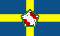
The flag of Pembrokeshire consists of a yellow cross on a blue field. In the centre of the cross is a green pentagon bearing a red and white Tudor rose. The rose is divided quarterly and counterchanged: the inner and outer roses have alternating red and white quarters.[5][6]
On television and film
Pembrokeshire is a popular location for filming locations. The following is a list of movies and television programmes filmed in Pembrokeshire:
- Moby Dick (1956) The coast off Pembrokeshire
- The Lion In Winter (1968) Filmed at Pembroke Castle, Marloes Sands and Milford Haven
- The Onedin Line (BBC, 1971) Filmed near Milford Haven
- Under Milk Wood (1972) Filmed in Fishguard
- Jabberwocky (1977) filmed at Pembroke Castle and Bosherston
- Treasure Hunt (UK game show) (Channel 4, 1983) Filmed at Stack Rocks, Pembroke Castle, St. Florence and Tenby
- Chronicles of Narnia (BBC Television, 1988) Manorbier Castle
- Delerium (ft. Sarah McLachlan) Music Video (2000) Filmed on Newgale Beach
- Television ident (ITV, 2002) filmed at Broad Haven Beach (south)
- Pobl Porthgain (S4C,2003) Filmed in Porthgain
- Darn o Dir (S4C) Filmed in North Pembrokeshire, near Newport and Crymych
- I Capture The Castle (2003) Filmed at Manorbier Castle
- Magic Harbours & Magic Islands (BBC, 2003) Filmed throughout Pembrokeshire
- The Edge of Love (2008) Filmed in Tenby and Laugharne
- Part of Harry Potter and the Deathly Hallows (2010-2011)
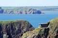 Pembrokeshire Coastal Fortress |
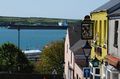 Harbour View Milford Haven |
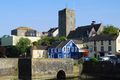 Pembroke Town Centre |
 New Cloisters St David's |
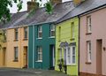
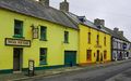 Colourful Cottages in Solva |
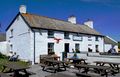 Old Point House Angle |
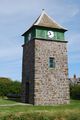 Clock Tower Marloes |
 Fishing Sunset Little Haven Sunset |
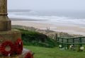 Deathly Hallows Shell Cottage Freshwater West |
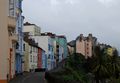
 Colourful Houses Haverfordwest |
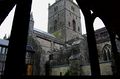
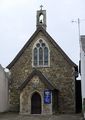 Methodist Chapel Haverfordwest |
 Milford Haven Red Blue Building |
 Tenby Crackwell St |
Local government
Under the Local Government Act 1888, an elected county council was set up to take over the functions of the Pembrokeshire Quarter Sessions. This, and the administrative county of Pembrokeshire were abolished under the Local Government Act 1972, with Pembrokeshire forming two districts of the new county of Dyfed: South Pembrokeshire and Preseli - the split being made at the request of local authorities in the area.[7] In 1996, under the Local Government (Wales) Act 1994, the county of Dyfed was broken up into its constituent parts, and Pembrokeshire has been a unitary authority.
Places of interest
Geography
Visitor attractions
|
Historical places
|
Beaches
- Whitesands Bay
- Newgale
- Broad Haven
- Little Haven
- Marloes
- Freshwater East
- Freshwater West
- Broad Haven South
- Barafundle Bay
- North Beach Tenby
- South Beach Tenby
- Poppit Sands (Ceredigion - Pembrokeshire Border)
- Traeth Mawr, Newport
- The Parrog, Newport
References
- ↑ 1.0 1.1 1.2 1.3 1.4 1.5 1.6 Davies, John, A History of Wales, Penguin, 1994, foundations of pgs 17,19, 43, Migration of the Desi into Demetia, page 52 Demetia 17, 30, 34, ruling house of 52, 72, 85, 87, and the Vikings pages 85, relations with Alfred of Wessex, page 85, and the Vikings/Northmen page 98, and the Normans 106, 112, 114
- ↑ Warner, Philip, Famous Welsh Battles, pg 79, 1997, Barnes and Noble, INC.
- ↑ Media titles owned by Town & Country Broadcasting - Media UK
- ↑ AM calls for A40 funds - western telegraph - 9.11.2006
- ↑ UK Flag Registry
- ↑ CRWFlags.com
- ↑ Wood, Bruce. The Process of Local Government Reform: 1966-1974. 1976.
External links
- Pembrokeshire at the Open Directory Project
- Pembrokeshire county council
- Visit Pembrokeshire
- Pembrokeshire Coast National Park
- Pembrokeshire Wales
- Pembrokeshire Pictures
- Pembrokeshire Beach Guide
- Pembrokeshire Beaches - Windsurfing, Kitesurfing and Surfing
- PembrokeshireSport.co.uk - News of the county's sport
- My Pembrokeshire - news and community information
Further reading
- James, J. Ivor, Molleston Baptist Church-Reflections on the Founders' Tercentenary, V.G. Lodwick & Sons Ltd., Carmarthen, copyright 1968.
|
|||||||||||||||||||
|
|||||||
|
||||||||||||||||||||
|
||||||||||||||||||||||||||||||||||