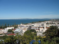
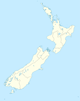
Napier, New Zealand
| Napier Ahuriri (Māori) |
|
|---|---|
 |
|
 Napier
|
|
| Coordinates: | |
| Country | |
| Region | Hawke's Bay |
| Territorial authority | Napier City |
| Government | |
| - Mayor | Barbara Arnott |
| Area | |
| - Territorial | 106 km2 (40.9 sq mi) |
| Population (June 2010 estimate)[1] | |
| - Territorial | 57,600 |
| - Urban | 58,600 |
| Time zone | NZST (UTC+12) |
| - Summer (DST) | NZDT (UTC+13) |
| Area code(s) | 06 |
| Website | http://www.napier.govt.nz/ |
Napier (Ahuriri in Māori) is a port city in Hawke's Bay, New Zealand. It has a population of 58,600 as of the June 2010 estimate.[1] Less than twenty kilometres separate the centres of Hastings City and Napier, and the two are often called "The Twin Cities" or "The Bay Cities". The population of the urban area of Napier-Hastings is 122,600 which makes Napier-Hastings the fifth largest urban area in the country, closely followed by Tauranga (116,000), and Dunedin (114,900).
The city is 320 kilometres (by road) north-east of the capital, Wellington. It has a population slightly smaller than the Hastings District, but as Hastings is administered as a district, Napier is the only official city in the Hawke's Bay region. Napier is the largest cross-bred wool centre in the Southern Hemisphere and is the export servicing area for Hastings District which is one of the largest apple, pear and stone fruit producing areas in New Zealand. It has also become an important grape growing and wine production area with the fruit passing from the growers around Metropolitan Hastings and then to Napier for exporting. Large tonnages of frozen meat, wool, pulp and timber pass through Napier’s port.
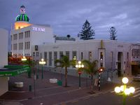
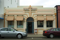
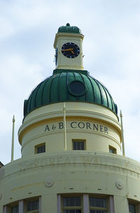
Napier is a popular tourist city, with a unique concentration of 1930s Art Deco architecture. It also has one of the most photographed tourist attractions in the country, a statue on Marine Parade called Pania of the Reef. Thousands of people flock to Napier every February for the Art Deco Weekend event, a celebration of its Art Deco heritage and history. Other notable tourist events attracting many outsiders include the region's annual Wine & Food Festival (named Harvest Hawke's Bay), and Mission Concert at the Mission Estate Winery in the near by town of Taradale.
Contents |
History
Māori history
Napier has well-documented Māori history. When the Ngāti Kahungunu party of Taraia reached the district many centuries ago, the Whatumamoa, Rangitane and the Ngāti Awa and elements of the Ngāti Tara iwi existed in the nearby areas of Petane, Te Whanganui-a-Orotu and Waiohiki. Later, the Ngāti Kahungunu became the dominant force from Poverty Bay to Wellington. They were one of the first Māori tribes to come in contact with European settlers.
Chief Te Ahuriri cut a channel into the lagoon space at Ahuriri because the Westshore entrance had become blocked, threatening cultivations surrounding the lagoon and the fishing villages on the islands in the lagoon. The rivers were continually feeding freshwater into the area.
European history
The first European to see the future site of Napier was Captain James Cook, who sailed down the east coast in October 1769. He commented: "On each side of this bluff head is a low, narrow sand or stone beach, between these beaches and the mainland is a pretty large lake of salt water I suppose." [2] He said the harbour entrance was at the Westshore end of the shingle beach. The site was subsequently visited and later settled by European traders, whalers and missionaries. By the 1850s, farmers and hotel-keepers arrived.
The Crown purchased the Ahuriri block (including the site of Napier) in 1851. In 1854 Alfred Domett, a future Premier, was appointed Commissioner of Crown Lands and resident magistrate at Ahuriri. A plan was prepared and the town named after Sir Charles Napier, hero of the Battle of Meeanee in the Indian province of Sindh. Domett named many streets in the settlement to commemorate the great colonial era of the British Indian Empire.[2]
The town was constituted a borough in 1874 and development of the surrounding marsh lands and reclamation proceeded slowly. Between 1852 and 1876 Napier was the administrative centre for the Hawke's Bay Province, but in 1876 the Abolition of Provinces Act dissolved provincial government.[2]
Development was generally confined to the hill and to the port area of Ahuriri. In the early days Napier consisted of an oblong mass of hills (Scinde Island) almost entirely surrounded by water, from which ran out two single spits, one to the north and one to the south. There was a swamp between the now Hastings Street and Wellesley Road and the water extended to Clive Square.
1931 earthquake
On 3 February 1931, Napier was levelled by an earthquake. The collapses and ensuing fires killed 256 people. The figure would later rise to 258 as two people were missing, presumed dead following the quake. The town centre was destroyed and rebuilt in the popular Art Deco style of the time. Some 40 km² of today's Napier was undersea before the earthquake raised it.[2]
Although a few Art Deco buildings were replaced with contemporary structures during the 1960s, 1970s and 1980s, most of the centre remained intact for long enough to become recognized as architecturally unique, and from the 1990s onwards had been protected and restored. Napier and South Beach in the US city Miami are considered the two best preserved Art Deco towns, Miami Beach being mainly in the later Streamline Moderne Art Deco style. As of 2007, Napier has been nominated for UNESCO World Heritage Site status, the first cultural site in New Zealand to be nominated.[3]
Modern history
In January 1945, the German submarine U-862 entered the Port of Napier undetected. That event later became the basis of a widely circulated post-war myth that Kapitänleutnant Heinrich Timm took his crew ashore near Napier to milk cows to supplement their rations.
Napier Hill was the scene of a police siege of an armed offender in May 2009, with one police officer and the gunman killed, and two police officers and a member of the public wounded.[4]
Geography and climate
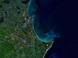
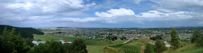
The town is on the Bluff Hill headland and the surrounding plain at the southeastern edge of Hawke Bay, a large semi-circular bay that dominates the east coast of New Zealand's North Island. The coastline of the town was substantially altered by a large earthquake in 1931. The topography puts Napier in danger from a tsunami, as the centre of the commercial city is near sea level – should the sea ever crest Marine Parade the sea would run through to Ahuriri.
Several smaller towns lie close to the city, the closest is Taradale the location of some of the region’s oldest established wineries. Other surrounding towns include Bay View, to the north, Clive, to the south, Flaxmere, west of Hastings, and Havelock North. As a territorial authority, Napier City is surrounded by the much larger Hastings District.
The town enjoys some of the highest sunshine hours in New Zealand. The climate is warm and relatively dry resulting from its location on the east coast of the North Island. Most of New Zealand's weather patterns cross the country from the west, and the town lies in the rain shadow of the North Island Volcanic Plateau and surrounding ranges such as the Kaweka Range. However, the town is prone to the remnants of tropical cyclones from the central Pacific Ocean, which occasionally are still at storm strength by the time that they have reached Hawke's Bay. Thunderstorms are not very common in Hawke's Bay with fewer than 10 thunderstorms a year. They are most common in the summer caused by the sometimes extreme surface heating. Hail from thunderstorms can damage vineyards and orchards. The hailstorm of 2 March 1994 created hailstones up to 3 cm in size and caused around NZ$10.8M worth of damage to orchards and vineyards. It remains New Zealand's most costly hailstorm.
| Climate data for Napier | |||||||||||||
|---|---|---|---|---|---|---|---|---|---|---|---|---|---|
| Month | Jan | Feb | Mar | Apr | May | Jun | Jul | Aug | Sep | Oct | Nov | Dec | Year |
| Average high °C (°F) | 24.4 (75.9) |
24.1 (75.4) |
22.6 (72.7) |
19.9 (67.8) |
17.1 (62.8) |
14.5 (58.1) |
14.1 (57.4) |
14.8 (58.6) |
16.9 (62.4) |
19.2 (66.6) |
21 (70) |
23 (73) |
19.4 (66.9) |
| Average low °C (°F) | 14.6 (58.3) |
14.5 (58.1) |
12.8 (55) |
10.2 (50.4) |
7.1 (44.8) |
4.9 (40.8) |
4.6 (40.3) |
5.2 (41.4) |
7.1 (44.8) |
9.4 (48.9) |
11.2 (52.2) |
13.4 (56.1) |
9.6 (49.3) |
| Precipitation mm (inches) | 48 (1.89) |
62 (2.44) |
85 (3.35) |
75 (2.95) |
62 (2.44) |
81 (3.19) |
92 (3.62) |
67 (2.64) |
65 (2.56) |
55 (2.17) |
57 (2.24) |
56 (2.2) |
803 (31.61) |
| Source: NIWA Climate Data[5] | |||||||||||||
Demographics
At the 2006 census, Napier had a population of 55,359, an increase of 1698 people, or 3.2 percent, since the 2001 census. There were 21,756 occupied dwellings, 1326 unoccupied dwellings, and 150 dwellings under construction.[6]
Of the population of Napier, 26,520 (47.9 percent) were male, and 28,839 (52.1 percent) were female. The city had a median age of 38.6 years, 2.7 years above the national median age of 35.9 years. People aged 65 years and over made up 15.6 percent of the population, compared to 12.3 percent nationally, and people under 15 years made up 21.2 percent of the population, compared to 21.5 percent nationally.[6]
Napier's ethnicity was made up of (national figure in brackets): 72.4 percent European (67.6 percent), 18.2 percent Maori (14.7 percent), 2.6 percent Asian (9.2 percent), 2.6 percent Pacific Islanders (6.9 percent), 0.4 percent Middle Eastern/Latin American/African (0.9 percent), 14.3 percent 'New Zealanders' (11.1 percent), and 0.03 percent Other (0.04 percent).[6]
Napier had an unemployment rate of 4.8 percent of people 15 years and over, compared to 5.1 percent nationally. The average annual income of all people 15 years and over in Napier was $22,700, compared to $24,400 nationally. Of those, 45.2 percent earned under $20,000 annually, compared to 43.2 percent nationally, while 14.5 percent earned over $50,000 annually, compared to 18.0 percent nationally.[6]
Tourism and architecture
Napier's major tourist attraction is its architecture, which draws Art Deco and architecture enthusiasts from around the world. The rebuilding period after the 1931 earthquake coincided with the short-lived and rapidly changing Art Deco era and the Great Depression, when little "mainstreet" development was being undertaken elsewhere. As a result Napier's architecture is strikingly different from any other city; the other notable Art Deco city, Miami Beach, has Streamline Moderne Art Deco. The whole centre of Napier was rebuilt simultaneously.
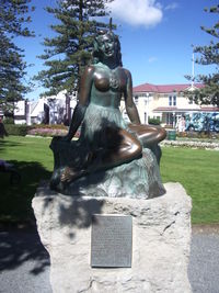
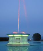
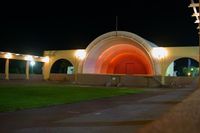
Other tourist attractions in Napier include The Hawke's Bay Museum and Art Gallery which features information on both the 1931 earthquake and Napier's redesign as an Art Deco city, the National Aquarium, the Soundshell and the Pania of the Reef statue. The Pania statue on Marine Parade is regarded in Napier in much the same way that the Little Mermaid statue is regarded in Copenhagen. In October 2005 the statue was stolen, but it was recovered a week later, largely unharmed.[7] Marineland was a tourist attraction from 1965 until it closed in 2009.[8] Tourists flock to Napier in February for Art Deco weekend and the Mission Concert Weekend, which has featured Chris De Berg, Olivia Newton-John, Eric Clapton, Kenny Rogers, Ray Charles and Rod Stewart.
Attractions nearby in the Hastings District include the Cape Kidnappers Gannet Colony and many vineyards bordering Hastings City. The large wine industry hosts the Annual Harvest Hawkes Bay Weekend.
Many people use Napier as a gateway to Hawke's Bay, flying in to Hawke's Bay Airport at Westshore from Wellington City, Auckland and Christchurch. Tourists also enter Napier by State Highway 2 along the coast and State Highway 5 from Taupo. The rail line in and out of Hawke's Bay has not had a passenger service since 2001.
Economy
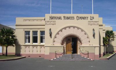
The range of industries in Napier and its environs include the electronics industry, the surrounding area wool trade, and the manufacture of fertilizer and wine. Napier was home to one of New Zealand's largest smoking tobacco plants. On 9 September 2005 British American Tobacco announced it would close the Rothmans factory, due to diminished demand. Production has moved to Australia. The Art Deco-style factory had been producing up to 2.2 billion cigarettes a year for the New Zealand and Pacific Island markets. In March 1999, 19 people lost their jobs there because "fewer people are smoking".[9]
Napier suffered a double blow from service amalgamation towards the end of the century. The local newspaper, the (Napier) Daily Telegraph, was combined with the (Hastings) Herald-Tribune to form a new regional newspaper Hawke's Bay Today. The Napier offices were closed down in favour of locating the offices in Hastings. The next rationalization saw the closure of the Napier Hospital, and the services where amalgamated with the Hastings Hospital creating the Hawke's Bay Regional Hospital located on the Hastings site.
Local government reform was mooted in the late 1990s and a referendum was held in 1999 proposing an amalgamation of the Hastings District Council with the Napier City Council. Although supported by approximately two thirds of Hastings voters, Napier voters rejected the proposal by a similar number and the proposal was defeated. The Mayor of Hastings, Lawrence Yule, has announced he will be standing for Mayor again in 2010 on the platform of local authority amalgamation.
Schools and higher education
The Eastern Institute of Technology is the main tertiary education provider for Napier.
Notable residents
- Rita Angus - painter
- Mike Boon - comedian
- Spencer Gollan - sportsman and racehorse owner
- Debbie Harwood - singer with When The Cat's Away
- Paratene Matchitt - artist
- Stuart Nash - politician
- Blair Peach - political activist
- John Psathas - composer
- Darren Smith - field hockey player
- Chris Tremain - politician
- Kel Tremain - former rugby player
- Percy Valentine Storkey - soldier and VC winner
- Chris Jackson - Former New Zealand international and Napier City Rovers association football player
Sister cities
 Victoria, British Columbia, Canada
 Lianyungang, China
 Tomakomai, Japan
References
- ↑ 1.0 1.1 "Subnational population estimates at 30 June 2010 (boundaries at 1 November 2010)". Statistics New Zealand. 26 October 2010. http://www.stats.govt.nz/~/media/Statistics/Methods%20and%20Services/Tables/Subnational%20population%20estimates/subnational-pop-estimate-jun2001-2010.ashx. Retrieved 26 October 2010.
- ↑ 2.0 2.1 2.2 2.3 History Napier and Taradale - Napier City - Hawke's Bay - New Zealand
- ↑ Napier Art Deco historic precinct - UNESCO World Heritage Centre
- ↑ "Napier shooting: Siege over as Molenaar's body located". The New Zealand Herald. 9 May 2009. http://www.nzherald.co.nz/nz/news/article.cfm?c_id=1&objectid=10571362. Retrieved 2009-05-09.
- ↑ "Climate Data". NIWA. http://www.niwascience.co.nz/edu/resources/climate/. Retrieved November 2, 2007.
- ↑ 6.0 6.1 6.2 6.3 Quickstats about Napier City
- ↑ "Pania statue found". The New Zealand Herald. 4 November 2005. http://www.nzherald.co.nz/topic/story.cfm?c_id=344&objectid=10353607.
- ↑ http://www.nzherald.co.nz/travel/news/article.cfm?c_id=7&objectid=10568846
- ↑ July 1999 decisions
External links
|
|||||||||||||||||||
|
||||||||||||||||||||||||||||||||