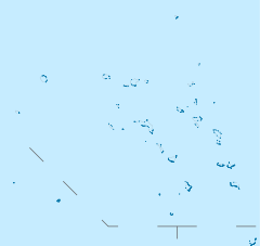
Majuro
 Lagoon shoreline on Majuro, February 1973 |
|
 Majuro (Marshall islands)
|
|
| Geography | |
|---|---|
| Location | Pacific Ocean |
| Archipelago | Marshall Islands |
| Area | 3.75 sq mi (9.71 km2) |
| Highest elevation | 10 ft (3 m) |
| Highest point | Laura |
| Country | |
|
|
|
| Demographics | |
| Population | 25,400 (as of 2004) |
| Density | 2,618.56 /km2 (6,782.04 /sq mi) |
| Ethnic groups | Marshallese |
Majuro (pronounced /ˈmædʒəroʊ/) is a large coral atoll of 64 islands in the Pacific Ocean, and forms a legislative district of the Ratak Chain of the Marshall Islands. The atoll itself has a land area of only 9.7 square kilometres (3.7 sq mi) but encloses a lagoon of 295 square kilometres (114 sq mi). As with other atolls in the Marshall Islands, Majuro consists of extremely narrow land masses which allow a person to walk from the lagoon side to the ocean side within minutes. At some points, the island is narrow enough to throw a rock from one side to the other.
The main poplation center, also named Majuro, population 25,400 (as of 2004[update]), is the capital and largest city of the Republic of the Marshall Islands. Majuro has a port, shopping district, hotels, and an international airport. The major population centers are the D–U–D communities: the islets of Delap–Uliga–Djarrit (listed from south to north, on the eastern edge of the atoll). Uliga is the main business district, and banking and tourism are increasingly important. Uliga is home to the College of the Marshall Islands, Assumption High School, and Uliga Elementary School where English is taught to all students. The government offices are located in Delap; and located at the eastern point of Majuro Atoll is the capitol building for the Marshall Islands. Delap also has several large stores. Djarrit is mostly residential and has the largest public primary and a secondary schools in the country, including Marshall Islands High School located near the north end of Majuro. At the western end of the atoll, about 30 miles from D–U–D by road, is the island community of Laura, a growing residential area with a popular beach. Laura has the highest elevation point on the atoll, estimated at less than 10 feet above sea level. Laura has the best soil for planting and is the home to several farms. Most of the roadway from Delap to Laura is a single two-lane paved road with houses on either side.
Contents |
History
Humans have inhabited the atoll for at least 2,000 years.[1] Majuro Atoll was claimed by the Empire of Germany along with the rest of the Marshall Islands in 1884, and the Germans established a trading outpost. As with the rest of the Marshalls, Maruro was captured by the Imperial Japanese Navy in 1914 during World War I and mandated to the Empire of Japan by the League of Nations in 1920. The Japanese administered the island came under the South Pacific Mandate, but mostly left local affairs in hands of traditional local leaders until the start of World War II. On January 30, 1944, United States troops invaded, but found that Japanese forces had previously evacuated their fortifications to Kwajalein and Enewetak, and were thus able to occupy the island without combat.[2]
Following the end of World War II, Majuro came under the control of the United States as part of the Trust Territory of the Pacific Islands. It supplanted Jaluit Atoll as the administrative center of the Marshall Islands, a status that it retains after the independence of the Marshall Islands in 1986.
Economy
Copra (coconut oil) is one of the main exports of the Marshall Islands, and Majuro receives copra shipments from most of the smaller populated atolls surrounding the area. Sport fishing is popular, and scuba divers are attracted to the area. Majuro serves as a transportation hub for the Marshall Islands, both for air service and shipping.
On September 15, 2007, Witon Barry, of the Tobolar Copra processing plant in the Marshall Islands' capital of Majuro, said power authorities, private companies and entrepreneurs had been experimenting with coconut oil as an alternative to diesel fuel for vehicles, power generators and ships. Coconut trees abound in the Pacific's tropical islands. Copra from 6 to 10 coconuts makes 1 litre oil.[3]

Transportation
Air
Marshall Islands International Airport, offering domestic and international service, is located on Majuro Atoll. It is served by two passenger airlines: Continental Micronesia and Air Marshall Islands.
Boat
Majuro Lagoon is an active port that is visited by ships and boats used for various activities. The Marshall Islands Shipping Corporation operates three ships (Aeaman, Langdrik, Ribuukae) and a landing craft (Jelejeletae). These boats are the main link for transporting people and supplies to and from the outer islands.
Additionally, the lagoon acts as a harbor for commercial fishing vessels, cruisers, sport fishing boats, outrigger sailing canoes and the occasional luxury yacht.
Sport
Majuro was initially scheduled to host the seventh edition of the Micronesian Games, in 2010. It subsequently renounced its hosting rights, citing a lack of adequate infrastructure.[4][5]
Sister cities
 Guam, United States (1973)
 Kawai, Nara, Japan
 Taipei, Republic of China (1999)
References
- ↑ http://www.archive.org/details/naturalhistoryof02deva p. 333
- ↑ Battle of Kwajalein and Enewetak
- ↑ Afp.google.com, Pacific Islands look to coconut power to fuel future growth
- ↑ "Scaled down Micro Games in 2010", Jon Perez, Saipan Tribune, April 9, 2008
- ↑ "Two Northern Pacific countries vying for the right to host Micronesia Games", Radio New Zealand International, May 8, 2008
External links
- Marshall Islands site
- Entry at Oceandots.com
- Recent photos of the rural portions of Majuro
- World War II photos of Majuro
- Battle of Kwajalein and Enewetak
|
||||||||||||||
|
||||||||||||||||||||