Chiapas
| Chiapas Estado Libre y Soberano de Chiapas |
|||
|---|---|---|---|
| — State — | |||
|
|||
 |
|||
 |
|||
| Country | Mexico | ||
| Capital | Tuxtla Gutiérrez | ||
| Municipalities | 118 | ||
| Largest City | Tuxtla Gutiérrez | ||
| Admission | September 14, 1824[1] | ||
| Order | 19th | ||
| Government | |||
| - Governor | Juan José Sabines Guerrero (PRD) |
||
| - Federal Deputies | PRI: 7 PRD: 5 |
||
| - Federal Senators | PRI: 1 PRD: 1 PVEM: 1 |
||
| Area Ranked 8th |
|||
| - Total | 74,211 km2 (28,653 sq mi) | ||
| Population (2005) | |||
| - Total | 4,293,459 | ||
| - Demonym | Chiapaneco | ||
| (Ranked 7th) | |||
| Time zone | CST (UTC-6) | ||
| - Summer (DST) | CDT (UTC-5) | ||
| HDI | 0.7390 - medium Ranked 32nd |
||
| ISO 3166-2 | MX-CHP | ||
| Postal abbr. | Chis. | ||
| Website | http://www.chiapas.gob.mx | ||

Chiapas (Spanish pronunciation: [ˈtʃjapas]) is the southernmost state of Mexico, located towards the southeast of the country. Chiapas is bordered by the states of Tabasco to the north, Veracruz to the northwest, and Oaxaca to the west. To the east Chiapas borders Guatemala, and to the south the Pacific Ocean, Chiapas has an area of about 74,211 km2 (28,653 sq mi). The 2005 Mexican census population was 4,293,459 people.
In general Chiapas has a humid, tropical climate. In the north, in the area bordering Tabasco, near Teapa, rainfall can average more than 3,000 mm (120 in) per year. In the past, natural vegetation at this region was lowland, tall perennial rainforest, but this vegetation has been destroyed almost completely to give way to agriculture and ranching. Rainfall decreases moving towards the Pacific Ocean, but it is still abundant enough to allow the farming of bananas and many other tropical crops near Tapachula. On the several parallel "sierras" or mountain ranges running along the center of Chiapas, climate can be quite temperate and foggy, allowing the development of cloud forests like those of the Reserva de la Biosfera el Triunfo, home to a handful of Resplendent Quetzals and Horned Guans.
The state capital city is Tuxtla Gutiérrez; other cities and towns in Chiapas include San Cristóbal de las Casas, Comitán, and Tapachula. Chiapas is home to the ancient Mayan ruins of Palenque, Yaxchilán, Bonampak, Chinkultic, and Toniná.
As of the mid 1990s, most people in Chiapas were poor, rural small farmers.[2] About one quarter of the population were of full or predominant Maya descent, and in rural areas many did not speak Spanish. The state suffers from the highest rate of malnutrition in Mexico, estimated to affect more than 40% of the population. "Without roads, cities or even small towns, eastern Chiapas is a kind of dumping ground for the marginalized, in which all of the hardships peasants confront in the highlands are exacerbated."[3]
The increasing presence of Central American gangs known as Maras, and illegal immigration from Central America in general (mostly immigrants on their way to the United States), stresses an already poor state. These immigrants are subject to human rights violations from Mexican authorities.
In 1994, violence erupted between the Mexican Government and the Zapatista Army of National Liberation (EZLN). There are currently 32 Rebel Autonomous Zapatista Municipalities (MAREZ) affiliated with the EZLN in Chiapas.
Contents |
History
Pre-Columbian
Chiapa de Corzo, in the central lowlands of Chiapas, shows evidence of periodic occupations throughout pre-history, and of continual occupation since 1400 BCE. The oldest Maya long count date yet discovered, equivalent to December 36 BCE in the Gregorian calendar, was found on one of several monument shards there.
In approximately 800 CE, Mangue-speaking Chiapaneca peoples from the north conquered the native Zoque and Maya towns. The mounds and plazas at Chiapas de Corvo date to approximately 700 BCE with the temple and palace constructed during the Late Formative, perhaps 400 BCE to 200 CE.[4]
The Maya city of Palenque was founded in the early Preclassic, with the first large structures constructed around 600 CE.
The Conquest through the ninteenth century
- See also: Spanish conquest of Yucatán, Captaincy General of Guatemala, Porfirio Díaz
Chiapas was conquered by Spain in the early 16th century, and became part of the Viceroyalty of New Spain, administered as part of the Captaincy General of Guatemala (what is now Central America), from Santiago de Guatemala.
When Central America achieved independence from Mexico in 1823, western Chiapas was annexed to Mexico. More of current day Chiapas was transferred after the disintegration of the Central American Federation in 1842 and the remainder of the current state taken from Guatemala in the early 1880s by President Porfirio Díaz.
Chiapas remained one of the parts of Mexico least affected by change, with the descendants of the Spanish continuing to control indigenous peoples through such institutions as debt peonage, despite attempts by the central government to abolish those practices.
In 1868, an armed native rebellion, led by the Tzotzil Maya, and also including Tzeltal, Tojolabal, and Ch’ol, nearly captured San Cristóbal, then the state capital, before it was suppressed by the Mexican army.
Late 20th century: indigenous disaffection
In the late 20th century, indigenous peasant farmers felt that their poor and largely agricultural region had been too long ignored by the Mexican government. A chief complaint was that many indigenous farmers were required to pay absentee landlords, despite repeated government promises of agrarian reform. Article 27 of the constitution of 1917 guaranteed indigenous peoples the right to an ejido or communal land. After the financial crisis of 1982, Mexico restructured its economy and de-prioritized land reform (long since completed in most of the country). The government of President Carlos Salinas de Gortari sought to liberalize Mexico’s closed economy. As part of this process, Mexico repealed the constitutional guarantee of communally owned ejidos for rural communities. As the North American Free Trade Agreement came into effect on in 1994, indigenous Chiapanecos felt increasingly left behind.
Zapatista National Liberation Army
Such disaffection led to the rise of the Ejército Zapatista de Liberación Nacional (EZLN, “Zapatista National Liberation Army”, commonly called the Zapatistas), which began an armed rebellion against the federal government on January 1, 1994 as a response to the implementation of the NAFTA. Zapatista rebels are mostly Tzotzil and some Tzeltal Maya, from the central highlands of the state, and the group’s spokesman, the Sub-Comandante Marcos, gained it international attention.
The group is named after Emiliano Zapata, iconic general in the Mexican Revolution of 1910, who is lionized for having defended the rights of poor farmers. Although the EZLN was in principle a peaceful movement forced to arms by the Mexican government, to guarantee the right to ejidos, there were a number of violent episodes in its history. The movement began in 1994 with the seizure of four cities (most notably San Cristóbal de las Casas), over 600 ranches, and control over about a quarter of the state.
After pushing the Zapatistas out of San Cristóbal, the Mexican army kept them bottled up in their jungle strongholds, cutting them off economically and politically. The Mexican government installed a solidarity program which while “ostensibly designed to alleviate poverty, […] instead became an instrument for rewarding political loyalty and contributed to the anger and frustration expressed through the Zapatista rebellion.”[5] In 1996, both sides signed a peace accord.
Meanwhile, landowner-funded paramilitaries sporadically repressed indigenous communities. A series of massacres ensued, typified by the 1997 Acteal massacre, where 45 indigenous refugees, mainly women and children, were killed in a church. [6]
In 2000, the EZLN renewed its resistance, autonomizing a number of jungle villages and sending a delegation to Mexico City. While the delegation did not obtain everything it sought, despite some support from President Vicente Fox, the villages remain under Zapatista control. In August 2003, the EZLN declared all Zapatista territory an autonomous government independent of the Mexican state.
The armed EZLN has mostly eschewed armed conflict, in favor of political efforts to build health clinics and schools in their communities. Anti-Zapatista paramilitary and military activity continues on the part of the Mexican government, however, threatening re-escalation.[7] Zapatista action continues now with the implementation of the Sixth Declaration of the Lacandon Jungle and the launching of The Other Campaign.
Social development policies
In order to mitigate the problems with the increasingly disaffected and rebellious population in Chiapas' Lacandon region, the federal and state government designed multiple social development programs. Many of these were criticized for being counter-insurgency projects, aimed at controlling and pacifying the indigenous population, rather than investing in their development and listening to their demands. Some of these programs include Plan Cañadas, PIDSS, and Prodesis.
Geography
Chiapas is geographically divided into five zones. These are the rainforest, the highlands, the central valley, the Sierra Madre de Chiapas, and the Soconusco.
Rainforest
The tropical rainforest of Chiapas, which includes the Selva Lacandona, is quickly being deforested. This is due to population pressures forcing highlanders into the rainforest. These include ladino (Spanish-speaking) landowners, indigenous and mestizo campesinos of the Ch'ol, Tzeltal, Tzotzil, Tojolabal and other groups. Migrants from Chiapas are being joined by Guatemalans fleeing the Civil War. These colonists constantly compete with one another for land, with the campesinos seizing or squatting on claimed land while landowners respond with the military or police. The economic activities of both groups contribute to the massive deforestation of the Lacandón. Rain falling on the forest drains into the Usumacinta river, which forms the border between Chiapas and the Petén department of Guatemala. The river flows into the sea in Tabasco, and deforestation may be a cause of the floods which inundated Villahermosa in 2007.[8]
Highlands
The Central Highlands have been the population center of Chiapas since the Conquest. European epidemics were hindered by the tierra fría climate, allowing the indigenous peoples in the highlands to retain their large numbers. Indigenous peoples provided labor for Spanish conquistadors, who also heavily settled the highlands. Indigenous highlanders were conscripted into labor service on plantations, drafted into debt servitude, which was so widely practiced that Chiapas earned the illustrious title of "Mexico's slave state" in the late 19th century.[9]
Since World War Two, the highlands have benefitted from a boom in the energy and petroleum sectors. However, economic growth in these industries did not reach the subsistence farmers of the highlands.[9] High population and land reform pressured the poor and rich alike to move into the eastern rainforest. The highlands are home to the cities of San Cristóbal de las Casas and Comitán. Close to the rainforest, San Cristóbal was one of the first sites seized by the Zapatista army in their attack on January 1, 1994.
Central valley
The Sierra Madre de Chiapas is cut through the middle by the Río Grande de Chiapas, known outside of Chiapas as Río Grijalva. The river flows from southwest to northeast. This area contains six of Chiapas' seven hydroelectric plants. The construction of these dams flooded hundreds of thousands of hectares, making lakes out of former ejido lands. The capital of Tuxtla Gutiérrez is located in the Central Valley, which enjoys a roughly tierra templada climate.
Sierra Madre de Chiapas
A continuation of the Sierra Madre del Sur, the Sierra Madre de Chiapas runs from northwest to southeast along the Pacific Ocean coast. It is extremely volcanic, resulting in high peaks, occasional eruptions and earthquakes, and rich soils. The mountains partially block rain clouds from the Pacific, a process known as Orographic lift, which creates a particularly rich coastal region called the Soconusco.
The largest city in the Soconusco is Tapachula, site of the seventh Chiapaneco hydroelectric plant, José Cecilio del Valle.[10]
Soconusco
The Soconusco lies in the southernmost corner of Chiapas. It shares many ties with Guatemala, which claimed the territory until 1882. Even while it was part of the Aztec empire, Soconusco was known for its cacao, but now the main product is coffee, which is grown on large plantations. Many of these plantations were owned by German-Guatemalans and employed indigenous peoples of the Mam group. The tierra caliente climate of Soconusco allows plantation agriculture to succeed, and the region also grows sugar cane, rice, maize, and plantains in addition to coffee.
Energy
The energy resources of Chiapas include the seven hydroelectric plants on Grijalva and its tributaries and petroleum in the north. Six out of these seven are located in the Central Valley, including the Manuel Moreno Torres plant in Chicoasén, the most productive in Mexico. All of the hydroelectric plants are owned and operated by the Federal Electricity Commission (Comisión Federal de Electricidad, CFE), while the petroleum resources are owned by Petróleos Mexicanos, PEMEX.[10]
Demographics
The state’s population is about 55% Mestizo, and 40% Indigenous, mostly of Maya ancestry. Around 35% of the indigenous population does not speak Spanish as a first language.
The 20th century saw massive population growth in Chiapas. From fewer than one million inhabitants in 1940, the state had about two million in 1980, and over 4 million in 2005.[9][11] Overcrowded land in the highlands was relieved when the rainforest to the east was subject to land reform. Cattle ranchers, loggers, and subsistence farmers migrated to the rain forest. The population of the Lacandón was only one thousand people in 1950, but by the mid-1990s this had increased to 200 thousand.[12]
Gross birthrate is one of the highest in the country at 22%, but it also takes an infamous first place regarding child mortality at a stunning 25%. Now, concerning the Distribution of the population, nearly 52% is still settled in rural areas, quite above the national average of 24%.
Chiapas is only 3% of the Mexican population. They produce 13% of country's maize, 54% of its hydroelectric power, 5% of the nation's timber, 4% of its beans, 13% of its natural gas, and 4% of its oil.[13]
Despite its rich supply of natural resources, Chiapas is an economically underdeveloped state, suffering chronic unemployment, below average literacy, and a high infant mortality rate.[2] “Only 11 percent of adults earn what the government calls moderate incomes of at least $3,450 per year (versus 24 percent nationally); less than 50 percent of households have running water (versus 67% nationally); and only 14 percent have televisions (versus 45% nationally).”[2]
Education
The conditions of poverty characteristic of this southern state are reflected in high levels of illiteracy at 21%, the lack of access to basic public utilities like running water, sewer systems and electric power. It has also the lowest availability in the nation of domestic goods such as television sets, washers, dryers and computers.
Institutions of higher education include:
- Universidad Autónoma de Chiapas (UNACH)
- Universidad Popular de la Chontalpa
Landmarks
- The Sumidero Canyon is occupied by an artificial lake, the dam , which produces a large percent of the electricity in Mexico. The sides of the cañon are covered with tropical vegetation.
- The Alvarez del Toro Zoo, ZOOMAT,[14] in Tuxtla Gutierrez, featuring local, native fauna.
- The Lagunas de Montebello, near Comitan.
- The Cataratas de Agua Azul (Blue Waterfalls), near Palenque.
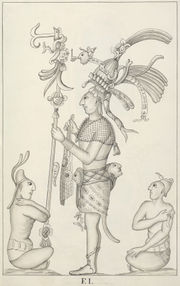
- The Maya ruins of Bonampak, in the Lacandon rainforest (La Selva Lacandona), feature probably the finest and better-known Maya murals. These are very realistic, depicting human sacrifices, music players and life at the royal court.
- The Lacandon Jungle is an important biodiversity spot, which recently yielded one of the newest and unique plant family discovered, represented by the plant Lacandonia schismatica.
- The Soconusco, the south-eastern coastal region bordering Guatemala, is a tropical agricultural area devoted to the intensive production of bananas and coffee, for the national and international markets.
- Chiapas is part of both the Ruta Maya and the Gringo Trail that link Cancun, Belize, Tikal, Lake Atitlan, San Cristóbal de las Casas, Palenque and other Maya archeological sites.
- San Cristóbal de las Casas is a favorite international tourist destination due to its colorful First Nations traditions and customs.
According to the limited geography model of the Book of Mormon, Chiapas is the most plausible location of the land of Zarahemla.
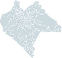
Municipalities
Chiapas is subdivided into 118 municipalities (municipios). See municipalities of Chiapas
Major communities
|
|
See also
- Chiapas conflict
Notes
- ↑ "La diputación provincial y el federalismo mexicano" (in Spanish). http://books.google.com.mx/books?id=i_GK_-6deKIC&pg=PA227&lpg=PA227&dq=22+De+Mayo+De+1824+durango&source=bl&ots=eyvDzsrMIz&sig=zYxzmtG7gTQgGV-WNDfHgqcG_kU&hl=es&ei=FtAxS9joN56ltgf-_ojFDg&sa=X&oi=book_result&ct=result&resnum=1&ved=0CAgQ6AEwAA#v=onepage&q=22%20De%20Mayo%20De%201824%20durango&f=false.
- ↑ 2.0 2.1 2.2 Collier, George A pg 16
- ↑ Collier, George A pg 11
- ↑ Lowe, p. 122–123.
- ↑ Collier, George A pg 12
- ↑ "Acteal: Between Mourning and Struggle (Executive Summary)". Fray Bartolome Centre for Human Rights. 1998. http://www.frayba.org.mx/archivo/informes/981201_acteal_between_mourning_and_struggle_frayba.pdf. Retrieved 2010-06-19.
- ↑ "Chiapas: paramilitary resurgence seen". World War 4 Report. 2007. http://www.ww4report.com/node/3232. Retrieved 2008-02-29.
- ↑ Washington Post Nov. 19, 2007: A12
- ↑ 9.0 9.1 9.2 Benjamin, Thomas. A Rich Land, a Poor People: Politics and Society in Modern Chiapas. Albuquerque: University of New Mexico Press. 1996.
- ↑ 10.0 10.1 Comisión Federal de Electricidad
- ↑ (Spanish) Website of the National Institute of Statistics, Geography, and Data Processing
- ↑ Benjamin, Thomas. A Time of Reconquest: History, the Maya Revival, and the Zapatista Rebellion. The American Historical Review, Vol. 105, no. 2 (April 2000): 417-450.
- ↑ Collier, George A
- ↑ Instituto de Historia Natural y Ecología
References
- Benjamin, Thomas. A Rich Land, a Poor People: Politics and Society in Modern Chiapas. Albuquerque: University of New Mexico Press. 1996.
- Benjamin, Thomas. A Time of Reconquest: History, the Maya Revival, and the Zapatista Rebellion. The American Historical Review, Vol. 105, no. 2 (April 2000): pp. 417–450.
- Collier, George A, and Elizabeth Lowery Quaratiello. Basta! Land and the Zapatista Rebellion in Chiapas. Oakland: The Institute for Food and Development Policy, 1994.
- Collier, George A. The Rebellion in Chiapas and the Legacy of Energy Development. Mexican Studies/Estudios Mexicanos, Vol. 10, no. 2 (Summer 1994): pp. 371–382
- Lowe, G. W., “Chiapas de Corzo”, in Evans, Susan, ed., Archaeology of Ancient Mexico and Central America, Taylor & Francis, London.
- Whitmeyer, Joseph M. and Hopcroft, Rosemary L. Community, Capitalism, and Rebellion in Chiapas. Sociological Perspectives Vol. 39, no. 4 (Winter 1996): pp. 517–538.
External links
 Media related to Chiapas at Wikimedia Commons
- (Spanish) Chiapas State Government
- (Spanish) Chiapas.com web's most comprehensive source of information about Chiapas.
- (Spanish) Zapatista National Army of Liberation
- (English) brief history of the conflict in Chiapas (1994-2007)
|
||||||||||