Guanajuato
- Guanajuato is the name of a state in Mexico and that state's capital city, as well as a river in the area. This article is about the state. For the city, see Guanajuato, Guanajuato; for the river, see Guanajuato River
| Guanajuato Estado Libre y Soberano de Guanajuato |
|||
|---|---|---|---|
| — State — | |||
|
|||
 |
|||
| Coordinates: | |||
| Country | |||
| Capital | Guanajuato | ||
| Municipalities | 46 | ||
| Largest City | León | ||
| Admission | December 20, 1823[1] | ||
| Order | 2nd | ||
| Government | |||
| - Governor | Juan Manuel Oliva Ramirez (PAN) | ||
| - Federal Deputies | PAN: 14 | ||
| - Federal Senators | Humberto Andrade Quezada (PAN) Luis Alberto Villarreal García (PAN) Francisco Arroyo Vieyra (PRI) |
||
| Area Ranked 22nd |
|||
| - Total | 30,491 km2 (11,772.6 sq mi) | ||
| Population (2005) | |||
| - Total | 4,893,812 (Ranked 6th) | ||
| Time zone | CST (UTC-6) | ||
| - Summer (DST) | CDT (UTC-5) | ||
| HDI (2007) | 0.812 - high Ranked 22nd |
||
| ISO 3166-2 | MX-GUA | ||
| Postal abbr. | Gto. | ||
| Website | Guanajuato | ||


Guanajuato (Spanish pronunciation: [ɡwanaˈxwato]) is a state in the central highlands of Mexico. It is named after its capital city, Guanajuato, which comes from P'urhépecha, meaning “Hill of Frogs.”[2][3] Las Ranas (“the frogs”) is a nickname for people from this state as frogs are their state animal. Guanajuato is the home state of former president Vicente Fox, muralist Diego Rivera, and singer-songwriter José Alfredo Jiménez.
After central Mexico and the Gulf of Mexico coast, Guanajuato was one of the first areas of Mexico colonized by the Spanish, in the 1520s, for its rich silver deposits. Guanajuato’s colonial architecture is very well preserved along with more than 35 old churches in its capital alone.
In addition to the state capital city of Guanajuato, the state includes the cities of Silao, San Luis de la Paz, Acámbaro, Celaya, León, Yuriria, Salamanca, Irapuato, San Miguel de Allende, Salvatierra—the first city of Guanajuato, Cortazar, Cueramaro, Tarimoro, and Dolores Hidalgo, the cradle of Mexican independence.
The first battle in Mexico’s war for independence resulted in a march from Dolores Hidalgo upon the capital of the state and the subsequent burning of the granary which held all the Iberian-born Spaniards (approximately 500 men, women and children), by peasants of pure Amerindian or mixed (Mestizo) descent who had been put to work in very harsh conditions.
Contents |
Geography
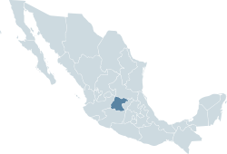
The state of Guanajuato borders the states of San Luis Potosí to the north, Querétaro to the east, Michoacán to the south, and Jalisco to the west. It has an area of 30,589 square kilometers (11,810.5 sq mi). In the 2005 census, the state had a population of 4,893,812 people. The literacy rate stands at about 88 percent.
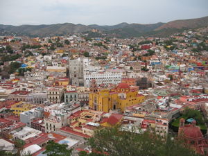
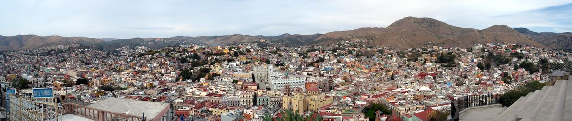
Guanajuato is located in the geographic center of Mexico, about three and half-hours north-west of Mexico City, and its capital city is one of Mexico’s most famous tourist spots. It is a UNESCO world heritage site[4] and city planners must abide by strict rules when building and refurbishing buildings in order to maintain their colonial integrity. The city is situated in the Veeder mountains at over 2,000 meters (6,562 ft) above sea level and the buildings climb up the side of the mountains surrounding the city center. The buildings are colorful and there are many historical buildings such as the Reyna and several haciendas-ranches or manor houses-that have been preserved as museums, public gardens and hotels.
Every October, Guanajuato hosts the annual International Cervantes Culture Festival, which is centered in the capital city. The festival features high-level performers and artists from around the world, as well as from many regions of Mexico, in addition to the (often overlooked) traditional presentation of plays by Miguel de Cervantes.
Demography
Guanajuato is one of the most densely populated Mexican states with 4,893,812 inhabitants, which corresponds to 152 persons per square kilometer, even without taking into account that 42% of the state population lives in the urban areas of León, Irapuato and Celaya.
The last 2005 census reveals a very young population: 60% are under 30 years of age. Since 1950 the state shows a constant population increase. Life expectancy is 75 years.
96% of the people say they practice the Catholic religion, ranking the state as the most catholic in the country.
It is the state with the smallest indigenous population. Only 0.2% of the Purépechas, Pames, Guamares and Guachichiles ancestors speak an indigenous language. The tribes that still exists are the Chichimeca Jonaz, Otomí, Mazahua and Purépecha
Major cities
- Acámbaro
- Celaya
- Dolores Hidalgo
- Guanajuato
- Irapuato
- León
- Moroleón
- Salamanca
- San Jose Iturbide
- San Francisco del Rincón
- San Luis de la Paz
- San Miguel de Allende
- Silao
- Uriangato
- Valle de Santiago
Education
The average education is 7.2 years. The percentages of termination of studies are 97.5% for primary school, 93.1% for secondary school, 94.7% middle superior [5].
Institutions of higher education include Universidad de Guanajuato, Instituto Tecnológico de Celaya, Universidad Iberoamericana and the Instituto Tecnológico y de Estudios Superiores de Monterrey.
Government and politics
The Constitution of the State of Guanajuato provides that the government of Guanajuato, like the government of every other state in Mexico, consists of three powers: the executive, the legislative and the judiciary.
Executive power rests in the Governor of Guanajuato, who is directly elected by the citizens, using a secret ballot, to a six-year term with no possibility of reelection. Legislative power rests in the Congress of Guanajuato which is a unicameral legislature composed of 36 deputies. Judicial power is invested in the Superior Court of Justice of Guanajuato.
The last local elections in Guanajuato were held on July 5, 2009.
Municipalities
The state of Guanajuato is divided into 46 municipalities, each headed by a municipal president (mayor). Municipalities are named after the city that serves as municipal seat; e.g., the municipal seat of the municipality of Guanajuato is the city of Guanajuato.
Economy
Today, Guanajuato’s mines are still among the richest-producing silver mines in the world (historically one of the largest). The state also produces tin, gold, copper, lead, mercury, and opals. Guanajuato comprises the ¨Bajío¨ region which has been historically renown as a rich cultivable area that has given economic support to the region since pre-Colombian times. Guanajuato also leads the nation in shoe production and various farm products such as lettuce and potatoes. The state’s main export products are motor vehicles and autoparts, footwear, leather goods, chemicals, electric machinery and materials, fruits and vegetables.
Panorama
References
- ↑ La diputación provincial y el federalismo mexicano - http://books.google.com.mx/books?id=i_GK_-6deKIC&pg=PA227&lpg=PA227&dq=22+De+Mayo+De+1824+durango&source=bl&ots=eyvDzsrMIz&sig=zYxzmtG7gTQgGV-WNDfHgqcG_kU&hl=es&ei=FtAxS9joN56ltgf-_ojFDg&sa=X&oi=book_result&ct=result&resnum=1&ved=0CAgQ6AEwAA#v=onepage&q=22%20De%20Mayo%20De%201824%20durango&f=false
- ↑ Ramirez Mora, Jorge Alberto (date unspecified, ca. 2005). ¡Así es! Guanajuato... Patrimonio de la Humanidad. Guanajuato, GTO, Mexico: RG Digital. no ISBN number.
- ↑ editorial staff (date unspecified, ca. 2005). Guanajuato Mexico. Guanajuato, GTO, Mexico: Editoriál Stampart. no ISBN number.
- ↑ http://whc.unesco.org/en/list/482
- ↑ http://portal.seg.guanajuato.gob.mx/sieeg/index.aspx
External links
- (Spanish) (English) (French) Guanajuato: Governmental portal
- Official financial website
- (Spanish) Guanajuato Travel: Official tourist information about the state (site suspended, as of 1/23/2010)
- Periódico a.m. A leading regional daily newspaper
|
||||||||||