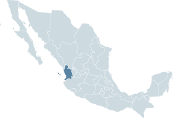
Nayarit
| Nayarit Estado Libre y Soberano de Nayarit |
|||
|---|---|---|---|
| — State — | |||
|
|||
 |
|||
 |
|||
| Country | |||
| Capital | Tepic | ||
| Municipalities | 20 | ||
| Admission | January 26, 1917[1] | ||
| Order | 28th | ||
| Government | |||
| - Governor | Ney González Sánchez (PRI) | ||
| - Federal Deputies | PRI: 2 PRD: 1 |
||
| - Federal Senators | PRI: 2 PRD: 1 |
||
| Area Ranked 23rd |
|||
| - Total | 26,979 km2 (10,416.7 sq mi) | ||
| Population (2005) | |||
| - Total | 949,684 (Ranked 28th) | ||
| Time zone | MST (UTC-7) | ||
| - Summer (DST) | MDT (UTC-6) | ||
| HDI | 0.828 - high Ranked 17th |
||
| ISO 3166-2 | MX-NAY | ||
| Postal abbr. | Nay. | ||
| Website | Nayarit State Government | ||

Nayarit (Spanish pronunciation: [naʝaˈɾit]) is one of Mexico’s 31 states and is located on the central west coast, bordering the Pacific Ocean. Nayarit is surrounded by the states of Sinaloa to the northwest, Durango to the north, Zacatecas to the northeast and Jalisco to the south with the Pacific Ocean bordering it to the west. Also in Nayarit are the cities and towns of Tepic, Ixtlan del Rio, Xalisco, Tuxpan, Santiago Ixcuintla, Acaponeta, Compostela, Tecuala, Ahuacatlán, Santa María del Oro, Amatlán de Cañas, San Blas, Matanchen, Zacualpan, Chacala and as well as the island settlement of Mexcaltitán. Also belonging to the state are the Islas Marias, Islas Tres Marietas and Isla Isabel, all in the Pacific Ocean. Its capital is Tepic, which is located inland and south on the Tepic River. Nearby is the Sangangüey volcano and the crater lake.
Contents |
Geography
Nayarit covers 26,908 square kilometers (10,389.2 sq mi), making it one of the smaller states of Mexico.[2] Nayarit is located between latitude lines 23°05' north and 20°36' south and longitude lines 103°43' east and 105°46' west.[3] Its terrain is broken up by the western ends of the Sierra Madre Occidental mountains. Its highest mountains are: San Juan, Sanguangüey, El Ceboruco, Cumbre de Pajaritos and Picachos.[4] Nayarit has two volcanoes, Ceboruco and Sangangüey. In the northeast are broad, tropical plains watered by the Río Grande de Santiago, a continuation of the Lerma River. The main state rivers are the Río Grande de Santiago, San Pedro, Acaponeta, Ameca and Las Cañas. The last two also form natural boundaries with the states of Jalisco and Sinaloa, respectively. Nayarit also has several lagoons such as the Santa María del Oro, San Pedro Lagunillas and Agua Brava.[5]
| Religion | Percent | Population of Tepic - 295,2040 |
|---|---|---|
| Catholic | 91.8% | 748,579 |
| Protestant Evangelical | 3% | 24,313 |
| Biblical Non-Evangelical | 1.3% | 10, 535 |
| Not Religious | 2.9% | 23, 607 |
Tepic is home to the Catedral de la Purísima Concepción or Cathedral of the Immaculate Conception.[6]
Education
- Instituto Tecnológico de Tepic
- Universidad Autónoma de Nayarit
- Universidad Tecnólogica de Nayarit
- Universidad Tecnólogica de la Costa
- Escuela Normal Superior de Nayarit
Agriculture
A variety of products are able to be produced in Nayarit due to its variable geography and climate. Volcanic soil, heavy rains and many altitude variations due to the mountains allow for the diverse crops. The crops include grain, sugarcane, cotton, coffee, and tobacco. Forest wealth is also taken advantage of and cattle raising is also important.[7]
Economy
Nayarit depends heavily on natural resources and agriculture to support their economy.[8] Cash crops such as mangos, coffee, tobacco and sugar cane are staples in the economy. Mining is a significant industry, due to large deposits of lead, copper, silver, and gold in the Nayarit area. There is also a fishing industry in Nayarit, but it is not as major as the mining or agricultural industries.
In recent years, Nayarit has worked to build its tourism sector, marketing the "Riviera Nayarita" as a safe, beautiful destination served by Puerto Vallarta International Airport. As a result, it ranked second in tourism investment in Mexico in 2008, was featured in North American tourism websites in Winter 2008-09,[9] and was the setting for the U.S. MTV reality competition "The Gauntlet 3" Gauntlet 3
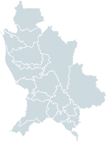
Municipalities
Nayarit is divided into 20 municipalities (municipios). See municipalities of Nayarit.
See also
- Western Mexico shaft tomb tradition
References
- ↑ "Portal del Gobierno del Estado de Tlaxcala" (in Spanish). http://www.tlaxcala.gob.mx/tlaxcala/enero-febrero.html.
- ↑ Gov Mx
- ↑ Map Gov Mx
- ↑ InfoPlease
- ↑ Gov Mx
- ↑ Churches Mx
- ↑ Common Borders
- ↑ Encyclopedia
- ↑ "Nayarit, Mexico - Strong in Tourism Growth, Investment, Job Generation and Safety". Reuters. March 4, 2009. http://www.reuters.com/article/pressRelease/idUS154403+04-Mar-2009+PRN20090304.
External links
(English) Riviera Nayarit official travel website
- (English) Punta Mita information and travel site
- (English) Nuevo Vallarta Travel site
- (Spanish) Nayarit State Government
- (Spanish) Breve Historia de Nayarit: Jean Meyer
- (English) Gringo's Paradise Real Estate
- (Spanish) Portal de Carrillo Puerto Nayarit, Mexico
- (English) Bucerias website info
- (English) Bucerias City Guide
- Punta Sayulita Real Estate
|
||||||||||